

calculus1
-
Posts
5,076 -
Joined
-
Last visited
Content Type
Profiles
Blogs
Forums
American Weather
Media Demo
Store
Gallery
Posts posted by calculus1
-
-
Still all snow. Approaching a full inch of snow after almost six hours of precipitation.

It's been fun to walk in and watch fall, though. I've missed this.
-
 4
4
-
-
Just can't seem to get the bigger flakes to stick around for very long. It's been snowing for about 3 hours now, the temperature has been sub-32 the entire time, the ground and road surfaces have been cold for days, and... I have somewhere between 1/4 and 1/2 of an inch of snow.
-
Much bigger flakes here now.
-
29.5/25 and 82% humidity. The temp had risen to 34 briefly, but quickly dove back under freezing. This is amazing, as we don’t normally get snow to fall during an entire below-freezing event.
-
2
-
-
Just got back from a 20-minute walk. Instantly sticking on impact. I love that we aren’t losing any moisture to reduce the air temperature. Steady light-to-moderate snow and nothing showing up on radar overhead. Can’t wait until we get to the stuff that actually does show up on radar. Deck’s already covered, as are all the grassy and leafy areas. The roads have yet to give way, yet.
-
2
-
-
First flakes! Just saw them!
-
3
-
-
10 minutes ago, wncsnow said:
My luck is pretty bad to get norovirus last night. Can't even get out of the bed to enjoy it but I'm hoping you all have a great day
Sorry about that, man. That really sucks after a 3-year drought of snow.
-
No flakes yet here in NE Hickory, but no sun either.
34.1/18
-
Lots of snow falling in Boone, Banner Elk, Beech Mountain, Blowing Rock per Resort Cams.
-
1
-
-
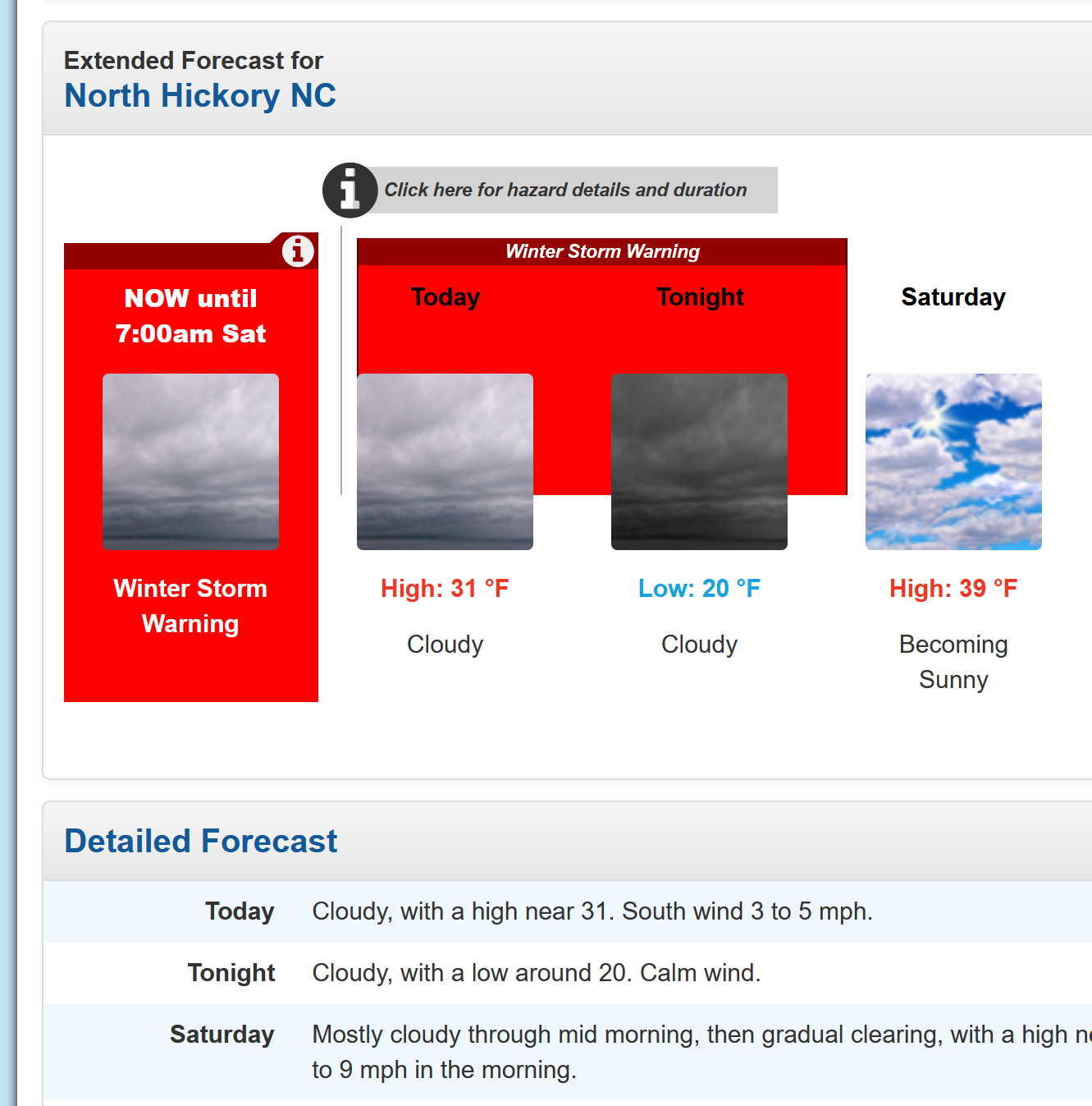
What does NWS GSP know that they're not telling me? My point-and-click forecast just changed to this:


-
30.7/18 for 59% humidity here IMBY in Hickory. Hard to see radar returns overhead with nothing hitting the ground, but I know this is part of the process. Atmosphere has to saturate.
-
1
-
-
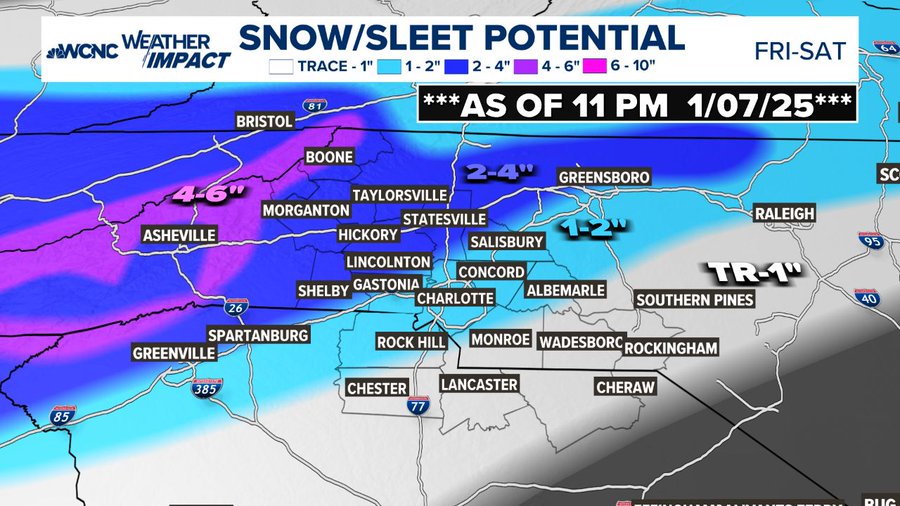
Feeling pretty optimistic of a good 2-4 inches of mostly snow.
-
1
-
-
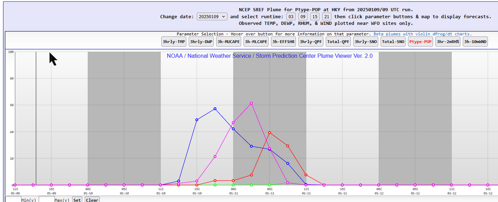
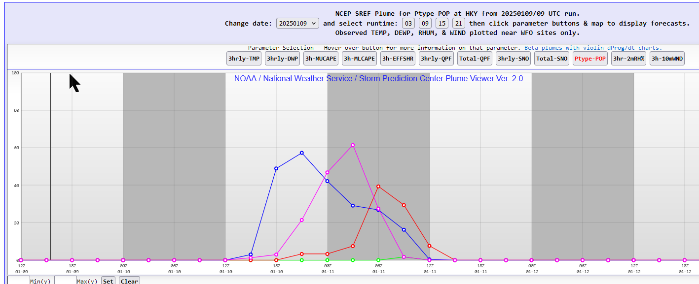
Here's the probability of precipitation type for the 09Z SREF plumes at KHKY. Snow to sleet to freezing rain. All frozen, though.
-
Latest NAM has 0.6 QPF for Hickory. It also retains the significant warm nose that first showed up on the 00Z version last night. We could have 1-2 inches of sleet on the ground if the NAM is correct. That’s some concrete. Wow!
-
1
-
-
9 minutes ago, Spidyr2k said:
Personally, I'm a big fan of sleet. It's like vintage snow. And never lost power during a sleet storm. ❄
Vintage snow! I like that.
-
3
-
-
18 hours ago, calculus1 said:
...
So, put that all together, and I went out on a limb with a forecast of 0-12 inches for Hickory. Bank on it!
I feel like NWS GSP copied my initial forecast from yesterday:
QuoteUnfortunately, there`s still a lot of room for error, and a lot of time for the forecast to change. If low-level profiles get even a tiny bit warmer, it`ll mean less sleet and more ice. If the warm nose gets stronger...less snow, more ice. If the system speeds up, QPF, which continues exhibit a lot of spread among ensembles, could change, which would alter both snow and ice totals. It looks increasingly likely, though, that the Upstate won`t escape at least a small amount of ice, and that zones as far north as I-40 will be under the gun for some sleet. Dreams of an all-snow forecast? Quashed.That sounds like 0-12 inches to me.
-
 2
2
-
-
Not sure how a winter storm is good for anyone affected by the hurricane….
Point taken.
My idea was that snow storms often bring a little bit of magic and wonder to people and are rarely destructive in our area. I figured the kids, at least, would enjoy seeing snow on the ground. But, that won’t be true for everyone, and it could be difficult for many still recovering and trying to rebuild. I was not trying to be flippant.
.-
2
-
-
1 minute ago, wncsnow said:
Don't like the trends tonight... may turn into an inch or less for leeside screw zone.
Oh, I am well aware of that horrible screw zone, but I think this is more likely to just be a smaller event overall rather than a big event elsewhere while the foothills get nothing. Of course, I’m not a pro met…
-
28 minutes ago, WNC_Fort said:
Ugh. That leeside minimum and Asheville snow hole are looking worse and worse
Brad Panovich gives you a leeside maximum in his call map. You’re looking good in Old Fort, I believe. Your town needs a good weather event after all the recent catastrophe. I hope this is a good one for you.
-
1
-
-
2 minutes ago, GaWx said:
Fellow wx weenies, I need some advice. If you were in Savannah with no chance for wintry precip, would you drive 4-5 hours to N Gwinnett county (NE of ATL) on Thu if family or friends offered you a room to stay in for the weekend and enjoy it with them? It is a few miles S of the Mall of GA.
This could easily be ATL’s biggest winter storm in 11 years and years til the next major one. But I’m worried ATL is going to get mainly ZR. While ice looks pretty and would be exciting to see, heavy ZR could mean long outages/no TV/cold inside and no snow or sleet to look at and walk in. So, it could get miserable. If I knew it were going to be nearly all snow and sleet, it would be an easy decision.
Weenies, what would you do?
Unless you don’t like the family members too much, i would go for it. The chance for glory is worth the risk you might not have TV for a bit, in my humble opinion.
-
3
-
 1
1
-
-
10 minutes ago, WinstonSalemArlington said:
I think Brad’s first call map seems pretty spot on with where we stand. My early call to colleagues at work today here in Hickory was 2-4 inches. Of course, I gave the usual caveats that it could be more and it could be less: Snow in the SE is never an easy forecast.
So, put that all together, and I went out on a limb with a forecast of 0-12 inches for Hickory. Bank on it!
-
1 hour ago, BooneWX said:
@calculus1we can top this. These folks have never seen the hotels on Hwy 70 in the snow. Magical stuff. We could even show them where the Spirit Halloween pops up once a year.
Absolutely! We have quite a few classics around here. Maybe the old Yesterday’s on NC 127 that’s now a plasma donation center will have a special sparkle with a couple inches of snow on the roof.
We do get great views of Grandfather Mountain from US 321-N approaching the Catawba River on clear days. We just imagine what it must be like to have snow on the ground around us rather than a few short miles to our west and a half-plus mile up.
-
1
-
2
-
-
That’s awesome, guys! Glad you could get together and do that. The pictures were amazing!
-
2
-
1
-
-
1 hour ago, wncsnow said:
I just have that nagging feeling that something is going to screw us still. Don't like the 18Z euro going dry again. It looked like the UK with a dry area around the escarpment too.
I always feel this way now. We have been burned for far too long.
1 hour ago, strongwxnc said:I always think a storm will not work. Period. I hate it. I hope we continue to see good trends.
100% agree.
On a positive note, it appears we will have no issue with the cold, no matter which model we are viewing. The QPF is the issue here. We need the storm to wind up and move up the coast for us to get those bigger totals. Of course, that brings in more mixing for those to our south and east. If it just slides along underneath us and out to sea, we are looking at much lighter totals than we could have in the first scenario.
-
2
-
1/10-11 super awesome winter SE OBS thread
in Southeastern States
Posted
Just went out for a walk with the family. We have about an inch as well. All snow still. Hoping that sleet stays south of us.