

calculus1
-
Posts
4,905 -
Joined
-
Last visited
Content Type
Profiles
Blogs
Forums
American Weather
Media Demo
Store
Gallery
Posts posted by calculus1
-
-
Ruler almost gone! 11.5 inches!

Sent from my Alcatel 6055U using Tapatalk-
 2
2
-
-
Ruler almost gone!

Sent from my Alcatel 6055U using Tapatalk-
4
-
-
11 inches just to your east in Hickory. Pouring down with special weather statement for heavy snow for next hour.
Sent from my Alcatel 6055U using Tapatalk-
2
-
-
11 inches in Hickory now! Just got special weather statement for very heavy snow for next hour! Crazy!
Sent from my Alcatel 6055U using Tapatalk-
5
-
-
8 inches here in NE Hickory with it still pouring down. Parents reported 9 inches in Lenoir at 7:00 AM.
Sent from my Alcatel 6055U using Tapatalk-
2
-
-
Heavy snow mesoanalysis from SPC. Bring it!
QuoteMesoscale Discussion 1700 < Previous MD 
   Mesoscale Discussion 1700
   NWS Storm Prediction Center Norman OK
   0932 PM CST Sat Dec 08 2018

   Areas affected...Western North Carolina into extreme southwestern
   Virginia

   Concerning...Heavy snow

   Valid 090332Z - 090900Z

   SUMMARY...Heavy snow will develop across western NC over the next
   few hours then spread toward extreme southwestern VA. Snow rates may
   approach 1-2" per hour at times.

   DISCUSSION...Significant large-scale forcing for ascent is spreading
   from AL/TN region ahead of a progressive short-wave trough. Leading
   edge of this forcing appears to be spreading into the southern
   Appalachians at 0330z with substantial precipitation, roughly 200 mi
   wide, trailing into central AL. Back edge of this stronger zone of
   ascent is moving east at roughly 30-35kt which suggests residence
   time in this heavier precip shield may last at least 6 hours. Wedge
   of cooler air is banked against the higher terrain across western NC
   and forecast soundings suggest much of this initial precip will fall
   as snow. However, forecast soundings exhibit substantial warming at
   AVL after 10z which correlates well with back edge of aforementioned
   zone of ascent. A mix of precipitation after 10z could spread across
   the southern half of western NC. Latest HREF Ensemble guidance
   supports this scenario with snow rates approaching 1-2" per hour.

   ..Darrow.. 12/09/2018
-
1
-
-
The latest version of the WSW for our area is quite bullish!
QuoteNCZ033-035>037-049-050-056-057-068-069-501>506-508-510-091115- /O.CON.KGSP.WS.W.0006.000000T0000Z-181210T1700Z/ Avery-Alexander-Iredell-Davie-Yancey-Mitchell-Catawba-Rowan- Cleveland-Lincoln-Caldwell Mountains-Greater Caldwell- Burke Mountains-Greater Burke-McDowell Mountains-Eastern McDowell- Greater Rutherford-Eastern Polk- Including the cities of Ingalls, Banner Elk, Newland, Bethlehem, Ellendale, Millersville, Taylorsville, Hiddenite, Stony Point, Statesville, Mooresville, Farmington, Fork Church, Mocksville, Advance, Swiss, Burnsville, Celo, Micaville, Ramseytown, Busick, Spruce Pine, Poplar, Hickory, Newton, St. Stephens, Salisbury, Shelby, Kings Mountain, Lincolnton, Crouse, Patterson, Kings Creek, Lenoir, Sawmills, Granite Falls, Jonas Ridge, Morganton, Pleasant Grove, Valdese, Ashford, Sugar Hill, Woodlawn, Old Fort, Marion, Nebo, Dysartsville, Fero, Glenwood, Forest City, Rutherfordton, Spindale, Tryon, Columbus, and Mill Spring 1004 PM EST Sat Dec 8 2018 ...WINTER STORM WARNING REMAINS IN EFFECT UNTIL NOON EST MONDAY... * WHAT...Heavy snow ongoing. Total snow accumulations of 9 to 15 inches expected, with up to 20 inches on the higher ridges between Mount Mitchell and Beech Mountain. * WHERE...The northern mountains of North Carolina, and a portion of the foothills and Piedmont between the Blue Ridge Escarpment and Interstate 77. * WHEN...From 7 PM this evening to noon Monday.
-
1
-
-
Great news from NWS GSP for the NW piedmont:
QuoteMeanwhile...the northern extent of the light precip can`t seem to make it into the nrn foothills and nw Piedmont, which is only allowing temps up in that region to cool off this evening, which means lower wet bulb temps, which means even more certainty that precip will either start as snow or quickly change to snow in the I-40 corridor east of the mtns later tonite. We await more guidance before applying any mid-course corrections.
-
This is my favorite map. The floor for Hickory is 9 inches! Crazy.

-
3
-
-
5 minutes ago, donsutherland1 said:
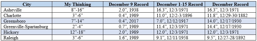
Even as residual model uncertainty persists, my confidence in a scenario where parts of North Carolina receive a significant to major snowfall is high. Right now, I'm thinking that Greensboro and Hickory could challenge or exceed their biggest snowfall for the first 15 days of December and possibly even their December record snowfall.
Parts of the region will also experience sleet, freezing rain, and rain. Those forms of precipitation will likely hold down accumulations to more modest levels in such cities as Charlotte and Raleigh. Nevertheless, I believe both cities will likely pick up 3"-6" snow.
Below is a table showing my current thinking, the December 9 daily snowfall record, the December 1-15 snowfall record, and the December snowfall record.
All in all, this should be quite an event for parts of the Carolinas and possibly a small portion of western Virginia.
I am trying really hard to rein in my excitement, but when Don Sutherland drops in and specifically mentions Hickory...wowza! It's about to get real...
Thanks to all the great mets and enthusiasts who frequent our forum and who lend their expertise to others. I so enjoy reading your thoughtful comments and explanations to those of us not as skilled in the art but very much as interested it. You guys are the best!
Here's hoping we reel this one in...

-
8
-
-
Zoom in on NWS GSP's forecast area. Released early afternoon:

-
2
-
 1
1
-
-
3K NAM Kuchera from Pivotal Weather. Not quite as bullish on the southern extent as the 12K NAM.

-
Thanks,@isohume. I appreciate you being willing to answer questions in here from time to time.The EC was used and weighted along with some GFS/CMC fields. The NAM profiles were not incorporated as it was deemed too warm at h85 and was an outlier, but will be watched for further trends. In my personal experience the NAM normally does quite well with the warm nose in this area.
Sent from my Alcatel 6055U using Tapatalk
-
3
-
-
@isohume, could you comment on why the ECMWF was not factored into the official forecast this afternoon? Why was the GFS solely relied upon? Thanks.
Sent from my Alcatel 6055U using Tapatalk-
2
-
1
-
-
WPC Probabilities of greater than 4 inches of snowfall 72 hours from now:

-
1
-
-
Brad P's latest call map. Seems miles away from NWS GSP:

-
2
-
-
NAM Kuchera is underwhelming to say the least:

-
1
-
-
Here is GSP's reasoning:
.SHORT TERM /SATURDAY THROUGH MONDAY/...
As of 250 PM Thu: Still high confidence on the occurrence of a
winter storm developing late Saturday into early Sunday across
the region. Trends in the models unfortunately do not lend much
additional confidence to precip types or transitions. Cold-air
damming still is a key component of the event. The models suggest
the CAD will be a bit stronger at the onset of precip, which
looks most likely Saturday afternoon as a stationary front sets
up between the incoming continental sfc high and the developing
coastal low. The general track of the low is still expected to be
across the Coastal Plain to our south, so the timing of the event
has changed little.

One appreciable difference with this fcst package is lower
overall QPF. Unfortunately for the sake of forecasting p-type
distribution/transitions, models continue to show midlevel temps
flirting with 0C for much of the event. Temps are expected to
remain above freezing for most of the area Saturday afternoon,
though the trend has been colder in latest guidance. A deep but
relatively cool warm layer aloft implies a mix of precip types
is possible late Saturday; increasing precip should strengthen
the wedge through diabatic cooling and profiles will support all
snow over an increasing portion of WNC through Sunday morning. Sfc
temps Sunday are especially tricky given guidance split across
the freezing mark. Have biased the fcst in favor of a GFS-based
blend that did well in last month`s wintry wedge event. Still,
where temps are above freezing sleet is expected to be the main
p-type. The NAM is substantially warmer with temps aloft than
any of the global models we have at our disposal. For now the NAM
profiles are being discounted and not used in the fcst process,
not only due to the consensus in the other guidance, but to help
maintain better forecast continuity--i.e. not to shift too much of
the accumulation from the snow to ice category. But this is a trend
that we will have to monitor in subsequent fcst shifts. We continue
to expect 8-12" of snow over the climatologically coldest part of
the CWA during CAD, i.e., the east-facing Blue Ridge Escarpment
and area extending east along I-40. "Snow" totals have declined by
a few inches over the northern GA/SC zones and in the more western
NC mtns, as more of the QPF is now expected to fall as sleet. Ice
accums remain at least advisory criteria along the fringe of the
sleet area. Confidence is already high enough to warrant a Winter
Storm Watch for all of our NC zones; one is being hoisted with
this package. This is at least 12 hours earlier than we would
normally issue a watch. We thus have decided to leave out all the
GA/SC zones for now and perhaps try to better define the p-type
transition zone. The expected sleet/ice amounts in these zones
will be more sensitive to forecast QPF and therefore a downward
trend could keep some areas out of warning crtieria altogether,
thus not warranting a watch there. Stay tuned.

WAA continues, albeit more weakly, as the sfc low pushes out to sea
Sunday night. At that time we will begin a slow transition from the
CAD/Miller-A forcing to that supplied by a shortwave/deformation
zone transitioning over the area. PoPs decline very slowly thru
Monday as a result. With the WAA, whereas we might normally expect
a transition to all snow across the area, we will continue to see
mixed p-types toward the south and east, wherever sfc temps remain
near or below freezing. Moisture becomes more shallow during this
time, too, putting the possibility of additional snow/sleet in
question as ice nuclei become scarce.

Impacts from the combination of what is expected to be a very wet
snow, combined with icing in some areas, are not looking any less
significant than what the previous shift expected, even though
total amounts may have come down with this package. Very windy
conditions are expected Saturday night and most of Sunday, which
makes falling trees/powerlines likely.
-
1
-
-
-
1
-
-
5 minutes ago, Wow said:
Interesting that it's picking up a lee side minimum
Yeah, that's definitely not a favorite feature of mine. I'm not sure why it's doing that either. When the moisture comes from the south, the mountains shouldn't have the effect that they do when it comes from the west or northwest.
-
1
-
-
Bonus flurries in Hickory this morning. I'm sure they're just blowing off the mountain, but it's a nice little surprise.
-
39 minutes ago, Waiting on snow said:
I should have stated outside of the mountains.

I enjoyed the phasing blizzard of 93 quite a bit in Lenoir, NC, outside of the mountains. I'm not too far away from that same spot now. I wouldn't mind a rehash.
-
All other things being equal, I would rather live in Wet Spoon than Dry Fork. Much greater precipitation chances.

-
 1
1
-
-
I think you've got a good chance there still too, but I'm no met.Yep, started work at Duke this summer. Actually I dont think where I live looks too awful as I'm in far west Durham County.
BTW, I appreciate your Hickory references when you quote stats/characteristics about model runs. You seem to often throw us in with lists that include the GSOs, ASVs, and CLTs of the world. Thanks!
Sent from my Alcatel 6055U using Tapatalk
-
1
-

December 8-10 Winter Storm Obs
in Southeastern States
Posted
Ruler now buried!
Sent from my Alcatel 6055U using Tapatalk