

OceanStWx
-
Posts
20,256 -
Joined
-
Last visited
Content Type
Profiles
Blogs
Forums
American Weather
Media Demo
Store
Gallery
Everything posted by OceanStWx
-
Significant Miller B Nor'easter watch, Apr 3rd-4th
OceanStWx replied to Typhoon Tip's topic in New England
Maybe even some accumulating snow too. -
Significant Miller B Nor'easter watch, Apr 3rd-4th
OceanStWx replied to Typhoon Tip's topic in New England
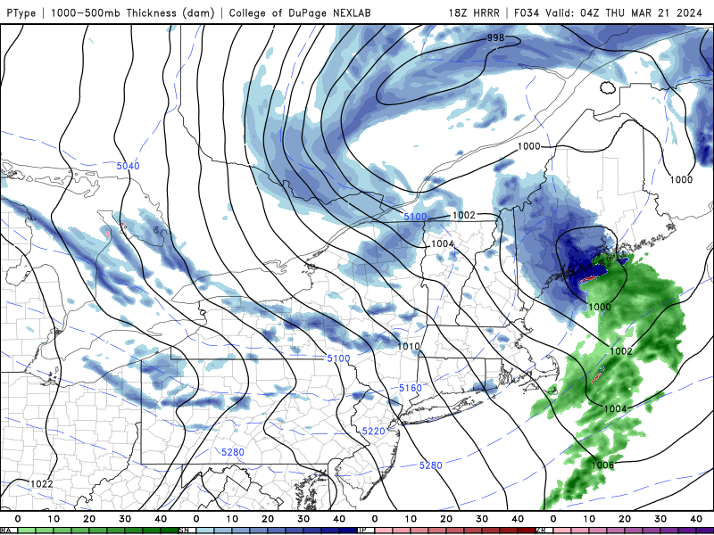
Extreme Forecast Index looking tasty from the overnight runs. QPF is pretty meh on this product, but that makes sense because 2"+ QPF in April is not unheard of. Plowable snow in April is much more rare, and so we're getting pretty uniform high EFI numbers. Most anomalous near the coast, where you wouldn't expect much April accumulation normally. The Shift of Tails black lines show your forecast potential, the highest of the high end members. A value of 2 is pretty good, and shows the biggest boom potential is just north of that mid level warm front. Congrats Dendrite? -
Significant Miller B Nor'easter watch, Apr 3rd-4th
OceanStWx replied to Typhoon Tip's topic in New England
Looking at LWM, they drop blow 0C at 950 mb like Wednesday afternoon and stay there for the duration. Now the models all have it mixing thanks to some 700 mb warm air initially, but by midnight-ish Wednesday night the whole column is cold enough for snow. -
Significant Miller B Nor'easter watch, Apr 3rd-4th
OceanStWx replied to Typhoon Tip's topic in New England
I'll say, there is really good lift in the snow growth zone around midnight Wednesday night. But the DGZ is also at like 500 mb. That always gives me pause. -
Significant Miller B Nor'easter watch, Apr 3rd-4th
OceanStWx replied to Typhoon Tip's topic in New England
-
The Congrats Dendrite Deck Destroyer 3/23-3/25 obs discussion
OceanStWx replied to Ginx snewx's topic in New England
I guess we had to call our plow contract in too. Mid shift ended up parking on the side of the road. -
A lot of pros could stand to use that mindset too. Post analysis of events you fumbled are way more useful than anything else you pick up along the way.
-
The Congrats Dendrite Deck Destroyer 3/23-3/25 obs discussion
OceanStWx replied to Ginx snewx's topic in New England
Very suck. Much bad here. I’ve got as much as 0.33” radial and shotgun blasts are going off all through the neighborhood. Caught a nice transformer flash while I was out measuring. Really confirms that 0.75” ASOS measured flat ice is the right number around here for an ice storm warning. -
The Congrats Dendrite Deck Destroyer 3/23-3/25 obs discussion
OceanStWx replied to Ginx snewx's topic in New England
Got the kids down just in time for the power and internet to go out. Genny’s running but can’t watch a damn thing. -
The Congrats Dendrite Deck Destroyer 3/23-3/25 obs discussion
OceanStWx replied to Ginx snewx's topic in New England
Between snow and sleet I’m at 6.1” today (0.5” pure sleet), and up to 0.2” radial ice now. Power has flickered four times now. -
This is the correct interpretation. 10% of the time snowfall will be greater than the number shown, or conversely a 90% chance that snowfall will be 29" or less. Ideally, 80% of the time your snowfall should fall between the high number and low number.
-
We're a unique site. Our inflation building was heated, but not to the safety standards you need when generating hydrogen. You probably could see the mushroom cloud from KLEW.
-
We don't? News to me. We ran out of helium a couple of weeks ago, but we launching again now. Pretty soon we'll be able to turn the hydrogen generator back on too.
-
Less of a squall now and more of an inverted trof as the coastal starts to take over. Just going to chuck up the advisories.
-
Pit2 FTW
-
Seriously though that is one of the big use cases the NWS is excited about anyway. The ability to run large ensembles quickly and frequently.
-
Some would argue it's always been useless.
-
No lies detected.
-
Best thunderstorms of the year right now?
-
When you end up well mixed, it also mixes out the big wind maxes aloft. Always seems to settle into that 45-55 mph range on the big westerly events.
-
44 is a big gust for IWI. That place is a wind pit.
-
LOL 06z GFS spitting out 19 inches for Rumford. 18 inches in 12 hours.
-
I'm ready. When I work overnights this time of year and sleep during the day, the closed door and sun beating on the roof can get my bedroom up into the 72-73 degree range. No thanks. I flip those heat pumps over to cooling.
-
Clearly nobody paid attention to the blizzard warning anyway.


