
weathertree4u
-
Posts
974 -
Joined
-
Last visited
Content Type
Profiles
Blogs
Forums
American Weather
Media Demo
Store
Gallery
Posts posted by weathertree4u
-
-
6 minutes ago, Holston_River_Rambler said:
Spring leaf index. 3 weeks+ early, now into TN
Oh ok, that makes sense; there are several trees swelling here; just noticed some Red Maples this afternoon as well as several Saucer Magnolias that are likely going to bloom much too early
-
1 minute ago, Holston_River_Rambler said:
It's here......
What is that?
-
1 hour ago, John1122 said:
These big events (maybe not quite this big) used to happen outside the mountains every 15 or 20 years but alas its been a while. Apparently my great grandfather used to tell my grandfather about this one. He was about 12 years old and lived at about 3000 feet on the Scott/Campbell Co line. He just said snow was up to his thighs during the storm. I'd never known the exact dates though. That looks like an all time southeast valley screw job.
Yea, evidently pretty tight gradient between whole bunch of snow and nothing
-
This would be an awesome storm to have in the modern era! @jaxjagman @John1122 @Holston_River_Rambler @carversgap
-
 2
2
-
 1
1
-
-
4 minutes ago, C.A.P.E. said:
Epic west-based -NAO on the way.

Paint me surprised lol
-
9 minutes ago, blizzardmeiser said:
April
Figured as much, why would this year be any different? The NAO will suddenly go negative in the Spring
-
- Mid 60's for an extended period of time in mid February - just so amazing - residents of the TN Valley will be sorely surprised when the larger scale pattern eventually flips; if we were to have a winter season like we had in my child hood -1970's-1980's - people would not know what to do not to mention if we had one similar to the 1960's where almost every season in that decade had at least one big storm and several seasons had seasonal totals well over 12" - just amazing! Anyone have any idea when we break from this multi-year crap pattern?
-
Mid 60's for an extended period of time in mid February - just so amazing - residents of the TN Valley will be sorely surprised when the larger scale pattern eventually flips; if we were to have a winter season like we had in my child hood -1970's-1980's - people would not know what to do not to mention if we had one similar to the 1960's where almost every season in that decade had at least one big storm and several seasons had seasonal totals well over 12" - just amazing! Anyone have any idea when we break out of this multi-year crap pattern?
-
5 minutes ago, weathertree4u said:
Just amazing rainfall and warmth being projected by the latest run of the GFS, just unbelievable; things will be literally leafed out by the end of February, just amazing.
Mid 60's for an extended period of time in mid February - just so amazing - residents of the TN Valley will be sorely surprised when the larger scale pattern eventually flips; if we were to have a winter season like we had in my child hood -1970's-1980's - people would not know what to do not to mention if we had one similar to the 1960's where almost every season in that decade had at least one big storm and several seasons had seasonal totals well over 12" - just amazing!
-
Just amazing rainfall and warmth being projected by the latest run of the GFS, just unbelievable; things will be literally leafed out by the end of February, just amazing.
-
1 hour ago, John1122 said:
Nice snow storm on the Euro and under 200 hours. Rarity this season. Really hope we can reel something in here.
here is to hoping it is on more than one model run, looks nice though
-
2
-
-
3 minutes ago, Holston_River_Rambler said:
@Carvers Gap Strat got interesting overnight after a few bland runs:
Euro (sadly only out to ten days):
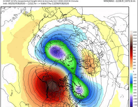
Yeah it does reconsolidate n the Euro, but that is the first time this season I've seen the Euro do anything like a split at the 10 mb level. Before it only made it up to 50 mb.
GFS:
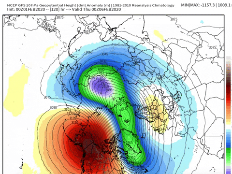
shows how that reconsolidation could be like a rubber band being stretched. Once you stretch it out, even if it temporarily returns to its original shape, there's still built up momentum that has to be worked out
Interesting - which of the two models has done better with this, not only in this season but in the past?
-
1
-
-
3 minutes ago, Holston_River_Rambler said:
The more I think about it this year, I wonder if these long range flip flops are due to how strong the SPV is and how well coupled it has been. It's like have a single cyclone determining the N Hemisphere pattern. Any little change affects everything.
I hope all of those are rhetorical questions you are posing because at this point I do not know of very many that can or have been able to figure this pattern out with any certainty much less where we are headed; based upon the way the models have done recently, I would say it is another head fake as much as I want to believe the opposite!
-
3
-
-
56 minutes ago, PowellVolz said:
I believe I read that it has rained everyday since December 20ish in Portland
.Portland Tennessee? I believe it!
-
13 minutes ago, jaxjagman said:
That's a pretty sickening look the last couple decades
Yea, allot of dates after 2000
-
14 hours ago, Coach B said:
I think you may mean days since Nashville has had greater than 1" of snow. We've had snow in most every winter month since then, but they have been Trace amounts or minor measureable accumulations.
Here is the link...
-
1
-
-
1 minute ago, Coach B said:
I think you may mean days since Nashville has had greater than 1" of snow. We've had snow in most every winter month since then, but they have been Trace amounts or minor measureable accumulations.
Could be
-
Just now, Carvers Gap said:
7-I will save the future climate talk for other forums...
As for the window between Feb 5-7, still a storm signal there. Still a trough at 500 still there. That time frame has warmed, but that date range is still almost a week out. Things can and will change. Could get worse and could get better. I am here to track storms. No way I am sticking a fork in a storm one week out with the config at 500 on the Euro. That is a nice storm evolution. But it is fair to say that temps have not trended well. The storm track is still there.
Just seems like we are heading back into a wet pattern
-
Just now, Holston_River_Rambler said:
Isotherm's latest update pretty much tosses the whole first half of Feb. Still, somehow, seems optimistic about late Feb and March.
Lol at this entire winter, not you personally
-
2
-
-
1 hour ago, John1122 said:
We averaged +20 during that stretch of n
Nashville is now in fourth place for greatest number of days without at least a trace snow, seven hundred fifty days I think
-
3 minutes ago, John1122 said:
We averaged +20 during that stretch of January.
Persistence usually wins no pun intended
-
8 minutes ago, Carvers Gap said:
Right now the GFS is all over the place. I think Jeff called it the "Choose Your Own Adventure" model. It has been for the past few days after d10. Some of its runs are a blast to look at and break down, but...Anyway, I don't think it is wrong about the trough out West. However, that evolution and that 500 low just spinning rarely works out. We just need some really strong cold to start showing up in order to undercut expected ridge at 500 after Feb 10. I like looking at the model just to see what it spits out. Sometimes it finds a piece of corn.
Yea that is opposite day from prior run
-
10 minutes ago, Carvers Gap said:
@Holston_River_Rambler, I was looking at the d10-15 on the 18z GEFS. At 500, it backed it up. The CFSv2 at 12z has the same deal. Cold is pressing and the airmass is colder. You know, I didn't look at the 12z EPS, but it has the same setup. The cold is pressing under the SE ridge. Not sure I buy that...again, we saw that once early in January on modeling and it busted. The 500 pattern won. So, I think we have to take into account that modeling has been far too cold at LR and we have to take into account(weighted much less obviously) that modeling was too warm during a pattern change in November. Holston, do you think you could post a gif of the daily mslp anomoly from d10-15 of the EPS(edit)? Watch that high spread out. I didn't look at the surface. The trend at 12z is for a much bigger high in the northern Rockies that spreads eastward. 2m surface temps and temp change reflect this d10-15. Pushes all of the way to the Apps. Holston, I think the WxBell analytics page might have more increments and provide a better look on the mslp anomaly. If you need me to, I can just post a screen shot. Need the daily version vs 7-day version. Thanks again.
@weathertree4u, that is ice city verbatim. They have been cutting trees off power lines in my neighborhood for weeks on end. It is a sign! LOL.
Overall, I suspect if this occurs it happens over the Ohio Valley...but at least it is interesting.
I just have bad memories from February of 1994. You can still see on some trees where they were snapped about ten feet now
-
 1
1
-
-
1 minute ago, Carvers Gap said:
LOL!!! Ya think? And of course, I agree. I actually think that is the snowmegeddon pattern but we somehow get on the right side of the pattern. I would actually be nervous in Akron, Ohio, though. That strung out front is on almost all modeling. Prob somebody to our north is going to be shoveling.
Long as we don't get bunch ice I am good
-
1
-
Fall/Winter Banter 2019-2020
in Tennessee Valley
Posted
Just throwing this out there. I am sure that there is actually a climatolgist someplace that has actually crunched the data on this theory but will be interesting to see if the same pattern repeats as we go forward. The data referred to was pulled from https://w2.weather.gov/climate/xmacis.php?wfo=ohx
I came up with an interesting theory last night concerning the weather. Many of us have wondered what happened to Winter for the second Winter in a row. Well, looks like it has to do with where we are in the solar cycle. Consider the following graph that starts with solar cycle 17/18, the minimum was mid 1940's every winter season except 1948/1949 had at least either January or February with double-digit snowfall, including the infamous winter of 1950/1951; if you look at the next minimum, the mid 1950's, every winter season after that had double digit snowfall in at least one of either January or February, sometimes both, including the record of most snowfall in a season occurring 1959/1960 when Nashville logged snowfall January/February/March for a total of 38.5"; if you look at the next minimum that was in the mid 1970's, this was followed by the harsh winters of the late 1970's; my point is that there seemed to be a lag of about a year - which means next year could be a bust also - but that for about five years after the minimum, harsh eastern winters seasons followed. The question is, is the lag time increased because the minimum is projected to take longer to reach? If you look at the second graph you can recall the snowier winters we had in 2010/2011 2011/2012, right after the solar minimum of cycle 23; just my thoughts, will be interesting to see if the prior pattern holds and what the next four or five winter seasons hold for the East.