
weathertree4u
-
Posts
974 -
Joined
-
Last visited
Content Type
Profiles
Blogs
Forums
American Weather
Media Demo
Store
Gallery
Posts posted by weathertree4u
-
-
6 minutes ago, Holston_River_Rambler said:
All that PV mess last night was more aimed at it looks more likely now that it has all season, BUUUUT, that's not saying much and doesn't mean it's gonna to happen.
Was hoping that was the case and that by posting that I could get a translation, thank you! Just an awful waste to see all the southern storms and not have enough cold air; if the last run of the GFS is to be believed, Jacksonville Florida could get a good storm!
-
 1
1
-
-
I gather from the previous postings of charts, diagrams and videos that the PV is not expected to assist any with cold air going forward, the missing ingredient to all of these great southern systems, really bites.
-
1 minute ago, Carvers Gap said:
As a follow-up, I would not be surprised in the least if the trough that forms is a Rockies to Apps trough w the EC has to deal with warm temps east of the Apps...just based on today's trends.
At the least it is different from last years endless warm. I am sure next year will be different too!
-
2 minutes ago, Carvers Gap said:
I was hoping @Holston_River_Rambler was going to fire up the gif machine! LOL. Let me see if I have enough account memory and I will post a map.
Great thanks!
-
Just now, Carvers Gap said:
Really nice run of the EPS incoming.
Nice in what way?
-
Just now, John1122 said:
It's very likely we don't see anything close to it again. It's one of the few paths towards snow for any of us with the marginal cold. Normally that storm in January or February would be golden. But the models are throwing out these storms and the results are what you'd normally seen in March or even April with great tracks but cold rain and elevated snow.
Yep, seems like last year it was similar in a way in that the real cold was locked into the upper midwest, this year, just cannot get cold to amount to anything to come down for any length of time into the continental us or at least it seems.
-
1 hour ago, John1122 said:
I just noticed how especially cruel to Knox County specifically that it is.
That said, I would have to think we would do a little better outside elevated areas with that kind of monster taking that path West of the Apps.
Middle TN gets the shaft on that run also, what else is new? Too bad it will not be a totally different solution the next time the model runs!
-
2 hours ago, John1122 said:
I just can't buy into it any more regarding the long range. This is been the winter of mythical blocking day 8-16 but it has failed every time. I will hope it's correct this time if for no other reason that it virtually always gets cold 10-15 days after the MJO moves into 7.
I am right there with you; seems like it is always out in the long range, then when we get to that period in the long range, it turns out to be rain; so, for me, I appreciate all the time everyone spends digging into the data but just seems like it is always changing.
-
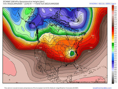
6 minutes ago, Carvers Gap said:
Sorry, cut off the date when I cropped it. The EPS map above is for Feb 6th. Looks remarkable similar to the GEPS.
Could February make us forget about the horrors of December and January?
-
3
-
-
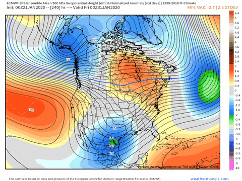
5 minutes ago, Holston_River_Rambler said:
OP Euro was pretty bad at 240 too.:
A zonal look in mid to northern Canada. Without that big upper low in the plains, you'd have a subtropical ridge across the whole CONUS, lol.
The Control evolves that look to some ridging over AK.
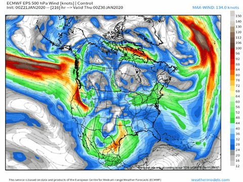
EPS looks like it is split between some members keeping the TPV over AK and some members seeing the ridging.
Actually some convection around the dateline, but north, this AM:
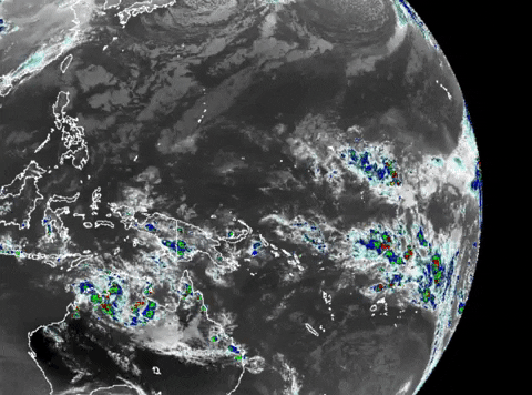
The Indian ocean looks about the same, but there is a critter of some kind creeping west from around Sri Lanka:
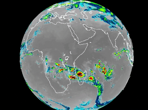
Meanwhile the SPV looks stout and only getting stouter:
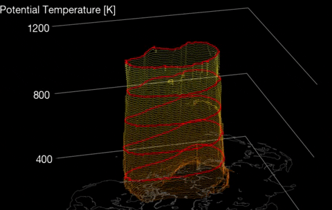
But all the cold air is on our side of the globe at the end of the EPS:
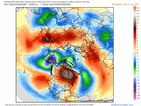
No sloshing needed!
And it'll all look different in 12 hours, lol.
Exactly! It will likely all look different with the noon runs!
-
9 minutes ago, Carvers Gap said:
The 18z GFS is a quite a run. Easily the best of the year with two Miller As(not counting this weekend's system) and a slider so far.
Yea, I agree, yet, the wild swings in the models make me real nervous to get on board.
-
2
-
-
1 minute ago, Carvers Gap said:
Here is the CMC for this weekend and the upslope event after....please note this is on the high end of things.

Interesting
-
1 minute ago, Carvers Gap said:
10 day run of the CMC had 4-6" over TRI and similar amounts on the Plateau w/ 2-3" amounts north of I40 in the valleys.
So are the models just seeing the warm up as more muted now or are they still in process of ingesting data? I honestly think that we will get a storm similar to today. For example, no one around here was really saying too much about flurries most of the day, granted, it is not sticking too well but no one forecasted there to be snow in the air most of the day today as it has been either.
-
2 minutes ago, Carvers Gap said:
It is not the same pattern, but it is still a lousy pattern which gets similar result here. The ridge in the north central Pacific will be gone, but to quote the MA forum, there is more than one pattern that can be bad for winter. Looks like the EPS is going to stick a trough in the Southwest and then leave unsettled weather under a ridge downstream where we live. The storm just under 200 on the Euro actually takes a good track with little cold available...we probably need to get used to that. Honestly, it is almost zonal in some ways when one looks at the 500 map and not the 500 anomaly map. That Southwest trough could be an error, but I doubt it this time. Synoptically, it looks right. Storm track looks to be suppressed by the Hudson Bay AN height anomaly which is also a new feature. It is a pattern that would unlikely produce snow, but is not without its chances as Jeff and John have noted. Overall, going to keep one eye over my shoulder at the storm inside of 200 and then HOPE that some transient cold shots can hook-up with the STJ. Of note, we don't want the BN heights over AK to set-up shop. If this turns out to be a non-winter(growing more likely by the day), I think two main attributes will have contributed, an active MJO/IO and a strong polar vortex. Pretty unusual pair, but there they are. With just over four workable weeks of winter left IMBY, going to have to hope early February has some cold.
Well, in my opinion, it is close enough to the same pattern to categorize it as the same, but splitting hairs at this point; I too am still hopeful that can pull something off but modeling does not provide much to be hopeful for honesty and like you stated yesterday, once we reach the third week of February, essentially, we are done with any appreciable winter weather. Just anxious to see ultra long range to see if there is any guidance that might suggest next year could be a different year with regards to overall winter patterns. The west has had several consecutive very good years, which have essentially erased the California drought but then have a contributing influence on the eventual fire season being rough as a result of all the growth. Anyway, rambled on more than usual lol
-
57 minutes ago, Tacoma said:
Well the quiet on here speaks for itself, this is terrible guys, we have the cold and can't get the moisture, then we'll get the moisture and it warms up.


Same occurring in the TN Valley area - north of Nashville here - looks like the same pattern to continue - got to break this pattern of poor winters - this is like the third one in a row where winter is MIA
-
Looks like we are headed back to the same pattern after a brief pause first of the week; cold, warm up, rain, then cold again. As long as the same players on the field - SER, craziness to expect the plays to be different.
-
8 minutes ago, Holston_River_Rambler said:
I actually thought it was a little bit worse than his first take, lol.
Lol goodness well eventually this multi year winter crap pattern will break, i assume.
-
7 minutes ago, Holston_River_Rambler said:
Isotherm just updated his winter forecast. Not many changes, but though some might be interested.
More persistence of same pattern
-
48 minutes ago, Carvers Gap said:
12z EPS supports the operational but obviously muted. A bit of a red flag is the drastic reduction in the QPF across much of North America. Overall, the trend is for increasing heights over much of eastern NA.
Which is not good I gather
-
3 minutes ago, Holston_River_Rambler said:
Well, maybe not DGEX snowfall, lol, but still nice. I was thinking that second piece of energy was going to pop another storm.
Interesting
-
5 hours ago, Mr. Kevin said:
Guys i think winter is over other than transient cold shots. They happen in the warmest winters. We are getting everything going against us for some reason this winter. Let's save this information and reconvene at the end of winter to see if i was correct or incorrect. Not being a debbie downer but being realistic and giving my opinion.
In reality, I think all of us are aware of the brief window compared to other areas of the county that we have for Winter in the Upper South, at least we are not pulling our hair out like members in some other forums, will not specifically mention them by name. My point is, I know for myself, I get my fix with about one winter storm, after that, I am good. I keep hoping for a winter that is a repeat of childhood winters of the 1970's - perhaps the erupting volcano in the tropics can make that happen for next year - but soon we will be turning the page anyway, so I will take what I can get and at least we have something to track, whether the pattern lasts or not, allot more fun than this time last year!
-
1
-
-
11 minutes ago, Carvers Gap said:
At any rate, the sustained big eastern trough/western ridge(EPO) at 500 that was seen universally on modeling for days...has now mostly disappeared on the 18z GEFS and 12z EPS. And when I mean disappeared...like it is barely on those runs at all.
Paint me surprised lol
-
1
-
-
3 minutes ago, Holston_River_Rambler said:
Maybe I'm wrong, but I want the GFS to have everything like 1000 miles south of us at range, lol. Gotta have room for the inevitable NW shift. I think we saw one go from Cuba to Michigan last year, over 10 days.
The model is just so volatile and variable with its solutions; we discuss it every year; not sure why we use it for forecasting honestly.
-
1
-
-
Seems like we will have the needed cold in the LR but the moisture shuts off almost completely, such a strange pattern.
-
1
-
December/January 2019/20 Winter Speculation Thread
in Tennessee Valley
Posted
Looks good, I wholeheartedly agree but we have had issues translating the long range into the short range lately, seems to always change - although I can say that doesnt not look like we will be in an extremely warm pattern going forward as previous which is always good too see if for nothing else to slow some of the plants down.