
weathertree4u
-
Posts
974 -
Joined
-
Last visited
Content Type
Profiles
Blogs
Forums
American Weather
Media Demo
Store
Gallery
Posts posted by weathertree4u
-
-
1 hour ago, Holston_River_Rambler said:
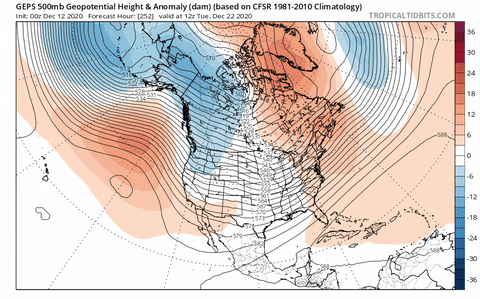
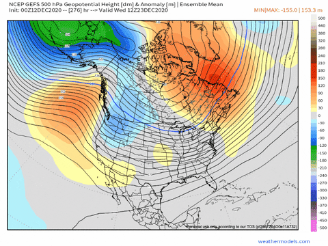
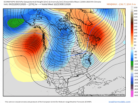
Overnight ensembles in the fantasy range still look like they want to quickly sweep the trough out of the southwest, and they start to make the Pac look more favorable (GEPS least of the three though):
GEPS:
GEFS:
EPS:
In loftier realms, the strat. continues to stratify. Nothing too dramatic, but still interesting:
The split at 50mb looks like it is going briefly to happen:
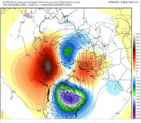
But the last image in the above, shows it at 10mb. Still pretty wound up.
The temperature maps at 10mb are more interesting to me this AM:
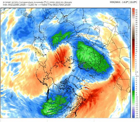
You can see some warming over the pole, but cooler temps look to be trying to wrap back in. One thing that I don't remember noticing before is warming over the North Atlantic. As long as I've been making these strat. gifs (admittedly not very long) the heat flux for warming attempts all have come from Asia and the Bering Sea. It could be that the ever elusive -NAO, which I haven't seen materialize as long as I've been active on weatherboards, is having an effect too this year.
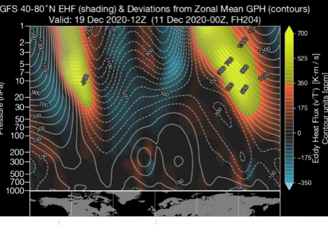
There does seem to be some connection between the geographic location of the heat fluxes and the -AO and -NAO. I have absolutely no idea if I'm reading this correctly, but it looks to me like the two feed into one another. Reading the above gif like a graph, where the map at the botton is one axis and the hPa heights on the lefty are the other, look above Baffin Island/ Bay it almost looks like the heating that extends down from 1 hPa, to close to 50 hPa is tied to the cooling to its left, cooling that is in part an attempt to balance the larger area of heating above Siberia on the map, and extending down to about 50 hPa too.
Now go back and look at the temps on the Euro's depiction of the SPV at 10 mb above, see how the warmer areas correspond. I'm hoping that there is some kind of precarious balance in this inbalance that can at least keep the SPV from dominating this winter.
Further south Maritime Continent convection looks sort of healthy, but a lot of it is south of the equator, which, I believe should mute its impact.
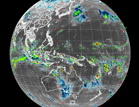
Hopefully that batch north of the equator, between 160 and 170 (with a little trailing back to 190) degrees longitude can kick it up a notch and help us out.
There is some convection over the Eastern Indian Ocean that does appear to be adding some...not sure what the right word here is... momentum? maybe... to the N. Hemishpere's flow:
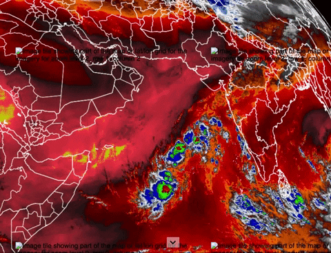
You can also see that in this chart:

You can see the bigger wave over N. Australia, just SE Darwin, and that is likely why the SOI (determined from looking at the differences between the MSLP between Darwin and Tahiti (look at all the sinking air there) is ~15 today. But again, all that OLR near Darwin is S. of the equator, so notice the arrows indicating divergent winds, all aimed S or SE. Looking at the MJO this way, you can see why it's in the COD. Conflicting, and weak, signals.
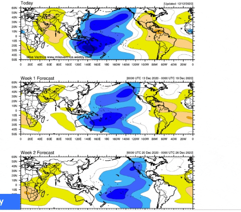
Still happy with Ventrice's projections, which would show it getting more into the W. Pacific.:
I am just happy to not see such warm temps this December; hopefully we can at least have a normal Winter season this year, a couple of snows would be a bonus, just cannot stand another year of mid 60's in January~
-
 2
2
-
-
6 hours ago, John1122 said:
The NAM rolled in guns blazing for the West and Mid Valley. Fizzles for the East Valley.

Lock it in!
-
12 hours ago, John1122 said:
The EPS basically kept us BN again at 12z in the extended range due to a West coast ridge that holds the SE ridge at bay. By late run Alaska and the SE are the only BN areas around North America.
Is this another Winter season where the cold and snow chances are always in the long range? Not really seeing it. Likely, hopefully, just because not aware of what or where to look.
-
 1
1
-
-
2 hours ago, John1122 said:
If you like bone chilling cold, this is the map for you. EPO blocking in Alaska and NAO blocking creates a -AO as well and the takes the cold from Siberia and dumps it through Alaska and into the Lower 48, aimed perfectly at our region.


We are overdue for a true arctic outbreak imo and it would fit well with some of the analog years I have seen like 1989
-
2
-
-
1 hour ago, Olhausen said:
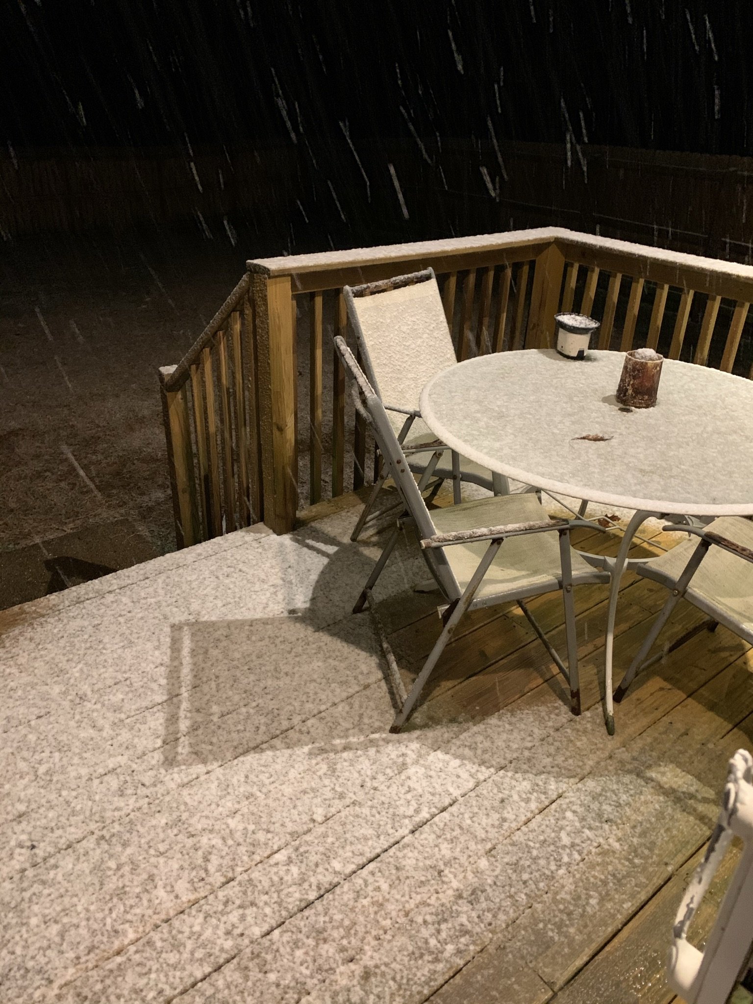
Snowing and accumulating with a temp of 34
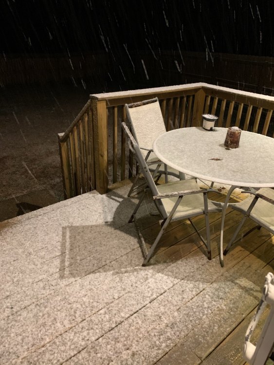
Yea, got about the same here in Cottontown, probably a little less, White House benefits from these marginal events because of the Highland Rim; just a little elevation goes a long way.
-
1
-
-
2 hours ago, John1122 said:
The Canadian went all in again and is stirring echoes of 1989. It has temperatures in the 10s on the Plateau and mountains in the afternoon on December 2nd. 20s elsewhere. Freezing weather and snow showers all the way into the deep south, 31 in northern Florida. In the period right after that the GFS went nuts and dropped 2 feet of snow in the Smokies, 6-10 inches on the northern Plateau and SEKY. Basically fantasy land stuff on that GFS run, but always fun to have winter weather back to talk about. Lets us get a look at model biases early and see if they hold up through winter.
Would not take much to beat last year; heck, at this point, I would like one hard freeze so I could stop mowing grass.
-
2
-
-
On 11/5/2020 at 12:14 PM, John1122 said:
All it takes is getting timing right for one or two events to make it a decent winter. Those have just been hard to come by except for small slivers of the forum area for a few years now.
One thing is for sure, we are getting pretty dry here in the Middle TN area. Need a good soaking rain.
-
1 hour ago, Windspeed said:
Recon is scheduled for today. By the time they get there, this may be a depression or even a TS.
Thunderstorm activity has continued to increase and become better
organized this morning in association with a well-defined low
pressure system located over the southwestern Gulf of Mexico.
Upper-level winds are gradually becoming more conducive for
development and, if this recent development trend continues,
a tropical depression or a tropical could form later today. The
low is expected to meander over the southwestern Gulf of Mexico for
the next day or so before moving slowly northward to
northeastward on Friday and Saturday.  An Air Force Reserve
reconnaissance aircraft is scheduled to investigate the disturbance
this afternoon.
* Formation chance through 48 hours...high...90 percent.
* Formation chance through 5 days...high...90 percent.
I am sure that this year tropically will be studied and restudied by meteorology students but it is amazing to me how when conditions are "tweaked" by just a little bit, like this year, so many of the thunderstorm complexes develop into something that has to be watched.
-
1
-
-
7 minutes ago, nrgjeff said:
I saw some 1965 hype, but didn't check snow. Severe wx that spring, lol!
My guess is Memphis and Nashville will do OK this winter. Southeast Tenn will be blanked, or have an upper low surprise. All or nothing, lol!
Well, it doesnt take much to be a better season that the last several lol
-
 1
1
-
-
On 8/25/2020 at 11:29 AM, AMZ8990 said:
4 weeks until fall y’all, We are getting closer!! Fun fact- in Memphis we’ve had four LA Niña winters since 2010. 3 of those 4 years produced measurable snow days. 1.8in on January 16th, 2018. 2.0in on January 6th, 2017. And 3.1in on February 11, 2011. January has been the best winter month for Memphis in La Niña setups over the last ten years statistically. ENSO neutral conditions have favored more December snows with 2 separate systems dropped .9in on December 26th, 2012, and a trace amount on December 30th, 2013. The daily snowfall record in Memphis of 14.3in also fell during a moderate La Niña on December 22, 1963. Long story short- La Niña winters are historically good for west Tn. Soon I’ll crunch some numbers and see how that translates to east and middle Tennessee winters.
The 1960's were great winters in the Mid-South; Nashville area got some great snows December that year as well. The big boy was on New Years that year that went just to the south of Nashville, we got snow but Huntsville and southern TN got hammered.
-
4
-
-
On 7/15/2020 at 9:27 AM, fountainguy97 said:
Here are the analog Temps!
Very similar to Carver's thoughts above!


The Precip is dry BUT its a dry December, wet January, dry February.
Here are the 3 months combined.

Here is the wet January

Anyway, I thought I'd just throw these out here
") I'm cautiously optimistic about this winter. Not so much because of a signal for massive cold but more of the chance we have to buck the recent winter patterns we have been stuck in. A weak nina or cool neutral can actually end up very favorable for alot of areas if we have the right setup elsewhere on the globe. PNA is also bucking its recent pattern of - in winter and + in summer (the last THREE winters have averaged a -PNA in DJF then prolonged + in summer). Currently we have seen a nice -PNA this summer. hopefully with some luck that can switch into the fall toward a +PNA through winter.
I'm cautiously optimistic about this winter. Not so much because of a signal for massive cold but more of the chance we have to buck the recent winter patterns we have been stuck in. A weak nina or cool neutral can actually end up very favorable for alot of areas if we have the right setup elsewhere on the globe. PNA is also bucking its recent pattern of - in winter and + in summer (the last THREE winters have averaged a -PNA in DJF then prolonged + in summer). Currently we have seen a nice -PNA this summer. hopefully with some luck that can switch into the fall toward a +PNA through winter.
Would not take much to make it a better winter imo
-
2
-
-
23 hours ago, jaxjagman said:
We haven't gotten much rain here the past few weeks.Our yard was looking great a few weeks ago but now is getting brown patches

Yea, that map is pretty accurate. North of town, we are starting to dry out as well, need a good rain. This Spring has been unique, usually we have a couple of "gully washers" before we move into the dryness of Summer, not so this year!
-
Was fairly localized in the Middle TN area; I am in Sumner county, northeast of Nashville near White House and while it did storm, we got lots of rain and wind maybe 30 mph
-
We were seemingly able to dodge most of the fowl weather here in Middle TN over night, thankful about that! Hope that holds for the future as well!
-
2
-
-
On 2/28/2020 at 6:34 PM, jaxjagman said:
Another suck winter for us,we'll be headed towards 3-years without any event bringing a inch or more snow next winter.
If the Euro is right with this system up coming you guys possibly could get a surprise in the east towards next weekend,alot would have to depend on this trough,to warm for us
ECMWF Deterministic FORECAST FOR: TYS LAT= 35.82 LON= -83.98 ELE= 981 12Z FEB28 2 M 850 1000 FZING SFC SFC 6 HR SNCVR TMP TMP 850 HGT WIND PCP QPF LIQ (C) (C) THK (FT) (KTS) TYPES (IN) (IN) FRI 12Z 28-FEB 0.0 -5.5 129 817 21006 FRI 18Z 28-FEB 3.9 -5.8 130 1011 25010 SAT 00Z 29-FEB 2.1 -5.0 130 1542 26006 0.02 SAT 06Z 29-FEB 0.5 -5.9 129 787 25007 0.02 SAT 12Z 29-FEB -1.3 -10.5 128 0 29007 0.02 SAT 18Z 29-FEB 3.5 -8.7 129 633 29005 0.00 SUN 00Z 01-MAR 0.2 -3.8 130 1744 26004 0.00 SUN 06Z 01-MAR -2.4 0.5 131 4415 18004 0.00 SUN 12Z 01-MAR -1.6 1.6 131 6039 19003 0.00 SUN 18Z 01-MAR 12.3 3.0 134 5601 23006 0.00 MON 00Z 02-MAR 9.6 4.3 135 6287 19005 0.00 MON 06Z 02-MAR 6.2 3.6 134 6067 19004 0.00 MON 12Z 02-MAR 5.5 4.2 133 5901 16005 0.05 MON 18Z 02-MAR 9.5 4.9 134 7191 20008 0.23 TUE 00Z 03-MAR 9.7 7.1 135 7839 19005 0.09 TUE 06Z 03-MAR 9.7 9.4 136 7630 19005 0.16 TUE 12Z 03-MAR 11.6 9.9 136 7695 21006 0.29 TUE 18Z 03-MAR 14.5 9.7 137 8411 23005 0.23 WED 00Z 04-MAR 14.6 9.9 137 8328 21007 0.08 WED 06Z 04-MAR 11.6 6.9 136 7482 26007 0.06 WED 12Z 04-MAR 7.9 4.3 134 8335 34004 0.01 WED 18Z 04-MAR 15.6 5.4 135 9064 25003 0.00 THU 00Z 05-MAR 11.6 8.2 136 8216 24003 0.00 THU 06Z 05-MAR 8.5 4.8 135 6512 06001 0.01 THU 12Z 05-MAR 6.2 3.6 133 7975 05008 0.55 THU 18Z 05-MAR 8.1 2.3 133 8724 05008 0.38 FRI 00Z 06-MAR 6.1 1.5 132 5735 01004 0.23 FRI 06Z 06-MAR 4.0 -0.8 131 5378 26004 0.00 FRI 12Z 06-MAR 3.9 -2.7 131 1718 27009 0.16 FRI 18Z 06-MAR 3.8 -4.6 130 1183 29011 0.06 SAT 00Z 07-MAR 0.8 -7.6 129 423 32010 0.12 SAT 06Z 07-MAR -1.1 -10.7 128 3 35009 0.05 SAT 12Z 07-MAR -2.6 -11.8 127 0 35008 0.01 SAT 18Z 07-MAR 2.4 -10.0 128 425 35009 0.00 SUN 00Z 08-MAR -0.2 -8.1 129 873 01005 0.00 SUN 06Z 08-MAR -3.9 -4.9 128 0 04004 0.00 SUN 12Z 08-MAR -5.7 -0.6 129 601 06004 0.00 SUN 18Z 08-MAR 7.7 0.8 132 4980 04003 0.00 MON 00Z 09-MAR 3.2 2.4 133 5956 10003 0.00 MON 06Z 09-MAR 0.9 3.6 132 7084 20004 0.00 MON 12Z 09-MAR -1.7 3.8 132 7089 20004 0.00.png.5fc4e66d376755e5c78c7174d52caee2.png)
Yea, was really hopeful based upon what was reading November onward that the Winter would turn around but we put another consecutive awful winter in the books in Middle TN; the real problem is that when the pattern eventually breaks and it will, that even the smallest Winter event will seem so out of the ordinary. Needless to say, if we ever have another winter like I had growing up in the 1970's, Nashville would think that the world was coming to an end!
-
2
-
-
12 hours ago, jaxjagman said:
Mem
CMWF Deterministic FORECAST FOR: MEM    LAT=  35.05 LON=  -90.00 ELE=   285

                                            12Z FEB27
                6 HR    6 HR    FROZN   TOTAL    SFC     2 M    1000    1000
                 QPF     CVP     PCP     QPF     PCP     TMP     500     850
                (IN)    (IN)    (IN)    (IN)    TYPES    (C)     THK     THK
SUN 12Z 01-MAR  0.00    0.00    0.00    0.06             7.7     548     135
SUN 18Z 01-MAR  0.00    0.00    0.00    0.06            15.8     548     135
MON 00Z 02-MAR  0.02    0.02    0.00    0.08            15.3     552     136
MON 06Z 02-MAR  0.24    0.24    0.00    0.32            12.6     552     135
MON 12Z 02-MAR  0.26    0.25    0.00    0.58            11.7     554     136
MON 18Z 02-MAR  0.01    0.00    0.00    0.59            18.2     556     137
TUE 00Z 03-MAR  0.01    0.00    0.00    0.60            17.9     559     138
TUE 06Z 03-MAR  0.11    0.02    0.00    0.71            17.0     561     138
TUE 12Z 03-MAR  0.56    0.38    0.00    1.27            16.3     560     137
TUE 18Z 03-MAR  0.60    0.26    0.00    1.88            17.6     562     138
WED 00Z 04-MAR  0.95    0.58    0.00    2.82            17.2     566     138
WED 06Z 04-MAR  2.21    1.13    0.00    5.03            13.9     564     137
WED 12Z 04-MAR  0.48    0.12    0.00    5.50            12.9     560     136
WED 18Z 04-MAR  0.44    0.11    0.00    5.94             9.3     549     133
THU 00Z 05-MAR  0.09    0.01    0.00    6.03             7.6     537     133
THU 06Z 05-MAR  0.00    0.00    0.00    6.03             7.1     539     132
THU 12Z 05-MAR  0.00    0.00    0.00    6.03             2.4     544     133
THU 18Z 05-MAR  0.00    0.00    0.00    6.03            15.7     548     134
FRI 00Z 06-MAR  0.00    0.00    0.00    6.03            13.2     551     135
FRI 06Z 06-MAR  0.00    0.00    0.00    6.03            10.1     552     136
FRI 12Z 06-MAR  0.00    0.00    0.00    6.03             6.9     553     135
One thing is for sure though, I bet that TVA/Corps of Engineers is stepping up the flows from the area holding facilities in advance of this system next week.
-
Looks like wet pattern is set to return with a vengeance
-
1
-
-
14 hours ago, Holston_River_Rambler said:
Anyone want to take a stab at deciphering this guy?
He is implying that we are headed into a cooler climate based on previous solar mins and the previous tilts of the Earth; could very well be but there are multiple drivers of climate and the weather in general, not just as in this case, solar mins and tilt of the Earth.
-
12 hours ago, Carvers Gap said:
Nothing to add to Jeff's comments regarding this weekend.
As for the period after Feb 27-March3, looks warmer on the EPS...though the control is not. It is just more of the same. Honestly, with COVID19 not being contained...I am all for the weather warming up ASAP. Let's see if that virus likes warm temps and higher sun angles. In other words, we need cold and flu season to end like yesterday. We need the weather to warm IMHO. I am 100% for it after this weekend. The warm look on the MJO might actually be a blessing in disguise.
What are you implying? Noting to see here, totally contained, well, aside from the people that we thought did not have it, like the flight steward on Korean Air. Of course the airline conveniently misplaced the flights the person worked on...
https://www.cnbc.com/2020/02/25/coronavirus-latest-updates-china-asia-markets.html
-
Have not heard much about Joe Bastardi in posts in any of the forums - just curious what his reasoning is behind yet another bust of a winter forecast.
-
47 minutes ago, franklin NCwx said:
That's what I'm looking for. We can overcome a -pna with a strong -nao. See December 2010 and January 11 for example. That was a nina following a moderate nino winter.
So, the pattern of warm winters could break next year? I would think that statistically, if not next year, then certainly the next we should see some difference.
-
1
-
-
Still hopeful that can pull something out of the magic hat before mid-March here in the Middle TN area but real close to getting the Spring bug here and real close to buttoning up this season and curios whether anyone has any thoughts this far out on next season?
-
1 hour ago, Nash_LSU said:
This is an actual picture I snapped while flying in to Nashville the other day.
That is it
-
13 minutes ago, nrgjeff said:
Actually phases 4-5-6 are still warm in March. I call those Indonesia or Maritime Continent. If I say West Pac I'm thinking 7-8-1 out by the Dateline. Sorry for the confusion. Maybe I'm not using convention.
Speaking of conflicting signals, the ECMWF did warm up the 12-20 day forecast overnight. Oh yeah Indonesia thunderstorms flared up. Diurnal or a true KW? I hope only diurnal. Would explain all the diurnal model zig zags too. West Pac out by the Dateline is still going. Winter lovers can pray it dominates.
Either way looks good next week. I-40 north of course! First storm may cut. Second comes in behind. That ought to be good along I-40 and points north. It gets TRI on both the front side and back side. That sequence won't work for KCHA; however, KTYS would have hope back side. KBNA is total crap shoot. Honestly BNA has been less lucky than CHA, which is wow!
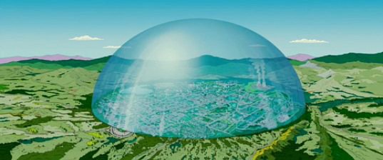
KBNA has a snow dome
-
1
-
December 2020 Medium/Long Term Pattern Discussion.
in Tennessee Valley
Posted
Not sure how reliable the CFS model is but it builds a glacier in the lower 48 for the first two weeks of January.