
weathertree4u
-
Posts
974 -
Joined
-
Last visited
Content Type
Profiles
Blogs
Forums
American Weather
Media Demo
Store
Gallery
Posts posted by weathertree4u
-
-
1 hour ago, John1122 said:
Are you implying I am cherry picking model runs?
I apologize - upon further review - I see how my post was not contributing to the overall knowledge base of the discussion so I removed them - though, seriously, fruit is going to start developing if we do not get some cold!
-
Just now, Holston_River_Rambler said:
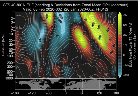
Here's how the "triplets" idea translates from 10 mb to 50 mb, to 100 mb, to 500 mb:
One thing I can say for sure is that this Winter has had lots to track, not necessarily with storms but with overall model changes.
-
 1
1
-
-
21 minutes ago, Carvers Gap said:
@Holston_River_RamblerI think the EPS/Euro handle the MJO regions really well. But as we have noted, the GFS/GEFS probably handles the strat a bit better. Not sure what to think at this point. That will likely have impacts at high latitudes that modeling isn't seeing yet. Looks like that has been on there for several runs.
Could that translate to cold here?
-
12 minutes ago, Carvers Gap said:
MJO is all over the place. The CPC RMM1GEFS MJO does show a four in a couple of weeks which does fit nicely with the GEFS SER. Looks like everything(so far) is very low amplitude which is why the cold can likely press. Question is, do we trust the GEFS? Personally, I go back and forth on this answer. After doing a good job recently with the MJO, it basically caved to the Euro(from yesterday). So, makes me think the EPS can be trusted. The GEFS with that SER and phase 2-3 MJO was out of sync with itself. I actually think the GFS handles change a bit better. It takes corners a bit better. The Euro turns slower but has better physics IMHO. Anyway, do you have a PV update? Forecasts and trends?
That is a good way of expressing the difference between the GFS and the EURO!
-
2
-
-
1 minute ago, Holston_River_Rambler said:
I posted that satellite over at southernwx and asked what people thought. Eric Webb responded to me:
"There's almost always convection over the Indo-pacific warmpool, satellite based IR doesn't tell really tell you anything. Plus, the upper level circulation signal tied to the convection hasn't been moving (it's quasi-stationary), thus it's not an MJO.
So that is good right?
-
35 minutes ago, AMZ8990 said:
When we want spring weather in March or early April, then we will all get some snow. I’m calling it now, lol. All this moisture is really saturating my golf course btw. I don’t know if it’s ever gonna dry out.
I know it is a little drier here north of Nashville but yea, we could use several weeks without any precip - chances are if it doesnt get it done the next few weeks - as far as snow is concerned - just gets very hard with increasing sun angle as we move into March to get it done; the system depicted on the morning run of the GFS this morning, if just a few hundred miles northwest, we give us all a pretty good snow, it is those chances, those tracking opportunities over the next couple weeks, that will make this interesting in my opinion.
-
1
-
-
2 minutes ago, John1122 said:
No apologies needed. Unfortunately the GFS has warmed up late the last several runs, which is a trend, and the SE ridge returning on both models is unfortunate. Feb 6th-10th we may get lucky, but if that warmth comes back after like it's being shown, we will probably be looking at late February to turn things around at the earliest, and even that's a crapshoot, since the Euro actually has the MJO climbing into Phase 4 by the 10th. By then we are in bowling ball season, where you hope you score with a ULL or some freak event like the blizzard if you don't live at elevation.
Guess analysis depends on ones outlook on things. I choose to be more optimistic about our chances going into the next couple of weeks.
-
4 minutes ago, John1122 said:
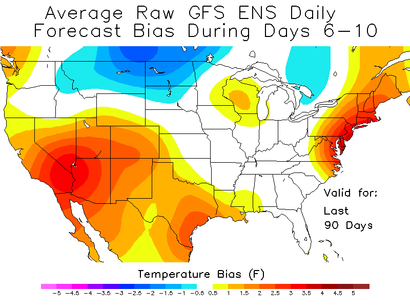
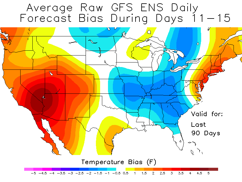
It has nothing to do with living any dying with every model run. We are in a hyper warm base state and the pattern for the last 4 winters have mostly stayed there outside of a brief period in 2018 when we had the cold dry weather. No drivers for cold here appear to be trending favorably in the longer range especially with the MJO looking to stay in the 4 or 5 areas even if at low amplitude. The GEFS looks opposite of the OP with the EPO, but due to it's position it also allows the SE Ridge to pop. Unfortunately the GEFS has been verifying about 6 degrees too cold in the LR. Meaning it's almost always too cold which leads to it's extreme snow means that never seem to happen. It's also popped a -EPO about 40 times this winter and I think it's not verified yet on that. We all know that any model that shows a -NAO is a fairy tale too. But that massive +NAO on the GFS wouldn't be a surprise at all.


These are the unfortunate realities of the GEFS D6-10 and 11-15 the last few months. Which means the long range cold that crops up there is mostly fools gold this winter. The Euro OP beats all models by far D6-10, including beating it's ensembles and it's still verifying 2 degrees or so to cold D6-10. So when the GFSENS are showing us at -1 in day 11-15, it's probably going to verify at +3-5 degrees. I shudder to think how warm we may be if the GFS is right, and it's better day 11-15 than it's Ens on temperature but still verifies too cold by a few degrees the last 90 days.
My apologies, I referenced the every model run because that was what was posted, the current post that I am replying too is referencing trends.
-
1 minute ago, John1122 said:
Unfortunately the trends aren't great and the season is slipping by fast. I'd say any sustained winter pattern isn't going to happen at this point, our best chance is getting one of those random quick hitters that will likely be melted off within 48 hours. The MJO, except on the GEFS, is staying in unfavorable locations now, never leaving the right side on most modeling. The GEFS has been heading right with it itself, it was low amp 8-1-2-3 recently, now it's middle of the C.O.D into 3. 3 is good for winter hear but it's on an island at this point. Other modeling seems to have it in the C.O.D of 4-5, which are not good for us. The GFS keeps throwing out big fantasy storms every other run, but so far it's verification rate on them this year is 0.00 percent. We probably have to score something between February 6th and 10th as we get a couple of cold days in that time frame. If we torch up again beyond that, we will have burned away most of low elevation winter.
This is not what you want to see unless you want some February severe possibilities. -PNA/+EPO/+AO/+NAO with the MJO heading towards phase 4 even on the GFS suite by this time. This is a repeat of the pattern that torched us the first week or two of January. Hopefully it's wildly wrong, but it's handled warmth much better than cold this year.


I would go crazier than I already am if I lived and died by every model run, again trends; personally, I have no expectation that we score 6 weeks of cold and snow - we live in the South after all - however, I am more hopeful than most years that we can score a storm or two in the next two weeks and change.
-
1
-
-
2 hours ago, John1122 said:
Not surprisingly, the Euro was much warmer vs the 12z run at D9/10. Canada is cold but there's no penetration into the upper midwest that run so our cold source is 10+ degrees warmer than 12z today so we basically get down to near normal. The Euro shows a -10 BN over Nashville the morning of the 7th. But it shows a 2m temp of 24 there during that frame. I believe Nashville's normal low is 28 around this time frame. So the -10 may be a little bit overdone on the anomaly map. But even that is brief, afternoon temp hit the 40s.
The western ridge is south of the PNA region and the heights are lower in Alaska which once again just means the air comes off the Pacific instead of across the pole.
GEFS is awful. Western trough/SE ridge. GFS op will have spring flowers in bloom late in the run.
I'm pretty sure if that takes place into mid February, winter is basically done but we will see if we can get lucky.
I think we should be looking, not to say that you are not, at the trends that are being portrayed with modeling, for example, what we know seemingly for sure is that it will get colder around the 5th; the pattern is just simply too complex I think at this time to expect modeling to all be on the same page, just my opinion.
-
4 minutes ago, tnweathernut said:
Good posts, Carvers..
It's definitely cold at day 10, but if the 12z GFS is close to correct at 500 at 240, it would almost be a certainty for FRIGID air to come at us toward day 15. MJO phase 1-3 FTW?
Around day 9, the 500 charts are pretty much a "money" look for overrunning to begin almost immediately behind the frontal passage day 9. Is it right, I don't have that confidence. Is it inside day 10...............YES!
Is that -45 just above the Great Lakes?
-
13 minutes ago, Carvers Gap said:
Accumulation amounts in the eastern half of Tennessee generally range from 4-14" snow with the greater amounts over the Plateau. Much of the eastern half of the forum area has 6" plus.
edit: eastern half defined in this case as mid-state to the Smokies
I think we are seeing some good trends!
-
8 minutes ago, Holston_River_Rambler said:
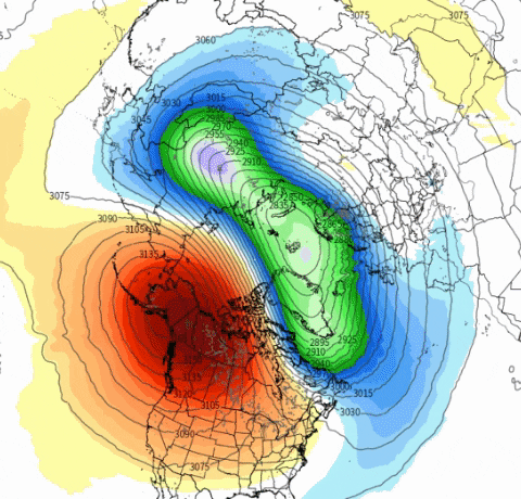
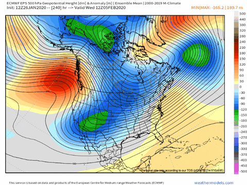
I think the key for the Ensembles is how they deal with the ridging that sandwiches the SPV. Because everything is so coupled, when you have the -EPO and NAO ridging, it percolates up to affect the strat. You can see it here as the yellows and oranges that correlate to the NAO and EPO regins in the arctic:
cross polar flow still there at the end, even more amplified as carvers said
Interesting
-
5 minutes ago, Carvers Gap said:
This run of the 12z EPS is really amped. All anomalous features over NA are deeper.
@carversgap i appreciate you translating the model and posting being sincere i really do!
-
3
-
-
1 hour ago, Hilton01 said:
Wxtree, I hope you do not stop posting. I enjoy reading your posts comments thoughts etc.. Very often, your posts, and the reply’s that are given, help me to better understand things. So thank you for that. We all know it is so very easy to misinterpret meaning tone intent etc. in another’s written text in these type of forums/formats and I am sure, after reading the posts, that that is all this is. So let’s all stay here keep posting be friends and get along! For if we can not do that, how can we ever expect it to snow in the Tn valley again!
@Hilton01not going stop posting for sure! Thank you for the kind words
-
1
-
-
1 minute ago, Holston_River_Rambler said:
Ok, specifically, tell me what is unrealistic about what I've posted? We can bring this back to pattern speculation by looking at the details and critiquing the specifics of what I posted.
I posted several maps that suggested the mid-week storm might over perform, but that the UKMET was on an island with how much precip it spit out as snow.
I posted some maps that suggested the SPV was going to stretch out and possibly split.
Jax was saying that the East Asian jet would retract, using a GEFS map of the eastern US for support. I see no evidence for that.
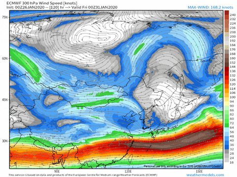
Looks fairly stout to me on the Euro and GFS in east Asia.
But Jax is much better with things like the East Asia rule and I respect him, so I saw no reason to contradict what he said. Maybe he sees something I don't.
Last post I am doing on this subject. I wasnt saying I found fault with what you or Jax had posted; I was saying that realistically, for me, with my experience looking at things, I was confused. Will go back to reading and not posting lest we get into another back and forth. Goodness.
-
Just now, Holston_River_Rambler said:
One of these days @weathertree4u Nashville will get a 12"+ storm again and when that happens I expect 6 months of optimism, minimum.
With all due respect, my posts are not intended to be negative, I am being realistic. I am sure that I could search the threads in this discussion or others and find some that would tend to portray others as negative, besides, we are getting off topic.
-
1
-
-
8 minutes ago, Holston_River_Rambler said:
Thus the discussion of the strat and to be fair the GEFS has just been knocking it out of the park so far.
I think me and Jax were talking about totally different things. Also, the EPS looks totally different at that range. If you would prefer more negative takes for your morning reading, I can support that.
Just posting thoughts, apologize that they are not as robust as others.
-
1
-
-
20 minutes ago, Holston_River_Rambler said:
In what way?
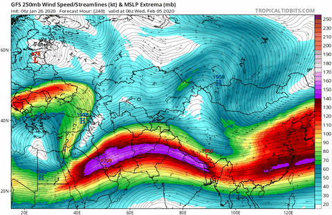
If we don't get help somewhere this pattern we are in is fixing to suck IMHO.When the jet retracts back into East Asia this is going to build back the ridge into East Asia and keep troughs from going through,so our active pattern won't be so active,Basically it would look just like the GEFS is showing in the long range
-
39 minutes ago, Holston_River_Rambler said:
I have given weathertree a confuse?
It was a lot at once, sorry, lol.
Indeed because seems to be in contrast to what other people are posting.
-
Latest run of the GFS looks good but I am suspect of its ability to accurately forecast anything past a few days - I know it is to be expected with such wild pattern swings, etc.
-
43 minutes ago, John1122 said:
Day 10 on the Euro, deep trough in the SW, eastern ridge. Mostly AN to well AN. No snow outside the NC high elevation border areas. Just can't seem to reel anything in at this point.
Winter of 1993 was awful like this. A trace of snow all winter until February 25th-26th when we got 4 inches. Then of course the blizzard hit and made it one of the most memorable winters in history from the Plateau eastward.
But most winters that go this poorly never recover in any significantly wintery way.
Oh, give it a day, evryone will be singing the modeling praises, then the next scratching their head in confusion, pretty standard winter for TN
-
Just now, Carvers Gap said:
Definitely a lot of talk on other sub-forums, this forum, and Twitter about the PV getting disrupted and maybe significantly. Combine that with an an MJO that is weakening...model mayhem about to be at defcon 1 with one driver potentially being moved to the passenger seat and another taking over. Going to see some looks that we like and some that we hate. Buckle up, probably about to get some model whiplash!
So, it is at least possible to see some of that cold in the PV make it south towards us?
-
1 minute ago, Holston_River_Rambler said:
Sure, things change or fall apart, but I've decided I kinda like at least looking at the control alongside the EPS smoothed means, since it gives a concrete picture of where things might really go, to compare to the smoothed mean that has a 50 different possibilities figured in.
That is true - according to the EURO looks like the PV is displaced headed towards the continental US - in reality, I will never be satisfied with the Winter season living in the South, I recognize that!
February/March 2020 Winter's Last Chance Thread
in Tennessee Valley
Posted
18" snow in south Louisiana is odd?