.jpg.82995912781a8a839ab578c3b293f48f.jpg)

weatherbo
-
Posts
6,475 -
Joined
Content Type
Profiles
Blogs
Forums
American Weather
Media Demo
Store
Gallery
Everything posted by weatherbo
-
My 5' snow stake is buried but it read 44" before the storm, so well over 60"
-
Snow and wind have let up considerably with another 5-6" possible through the night. Snow is too deep to walk or even snowshoe in, there's no power, and the road is closed for miles. Deepest snow I have ever seen. The house is almost buried.
.thumb.jpg.39af3485c102fc6fb55e0a06c759cdf4.jpg)
- 716 replies
-
- 26
-

-

-
Hi all, checking in from rural Marquette County. Have received 30-35" on top of the 44"that was otg when this started. Depth between 60-70". Another foot possible. The snow has bridged to the roof.
.thumb.jpg.402e97f986706cbebe6ea9e53ce3b1a8.jpg)
- 716 replies
-
- 22
-
-
-
SUPERIOR QD #4 (weather.gov)
-
I saw a report of 20 up in the arrowhead.
-
First serious taste of Autumn today.... mid to upper 40's all day with .25 of lake effect rain off a due north flow. With clouds and showers tonight, lows should only fall to the upper 30's.
-
Breezy autumn like day with low humidity and temps in the low 60's. Will be a cool one tonight with mid 40's, some 30's likely in the cool spots. Started weeding out some of the tired looking plants that don't receive enough sun anymore off the deck today and into the composter. Sure sign fall is here.
- 231 replies
-
- 3
-
-
- absolute trainwreck?
- abandon all hope?
- (and 1 more)
-
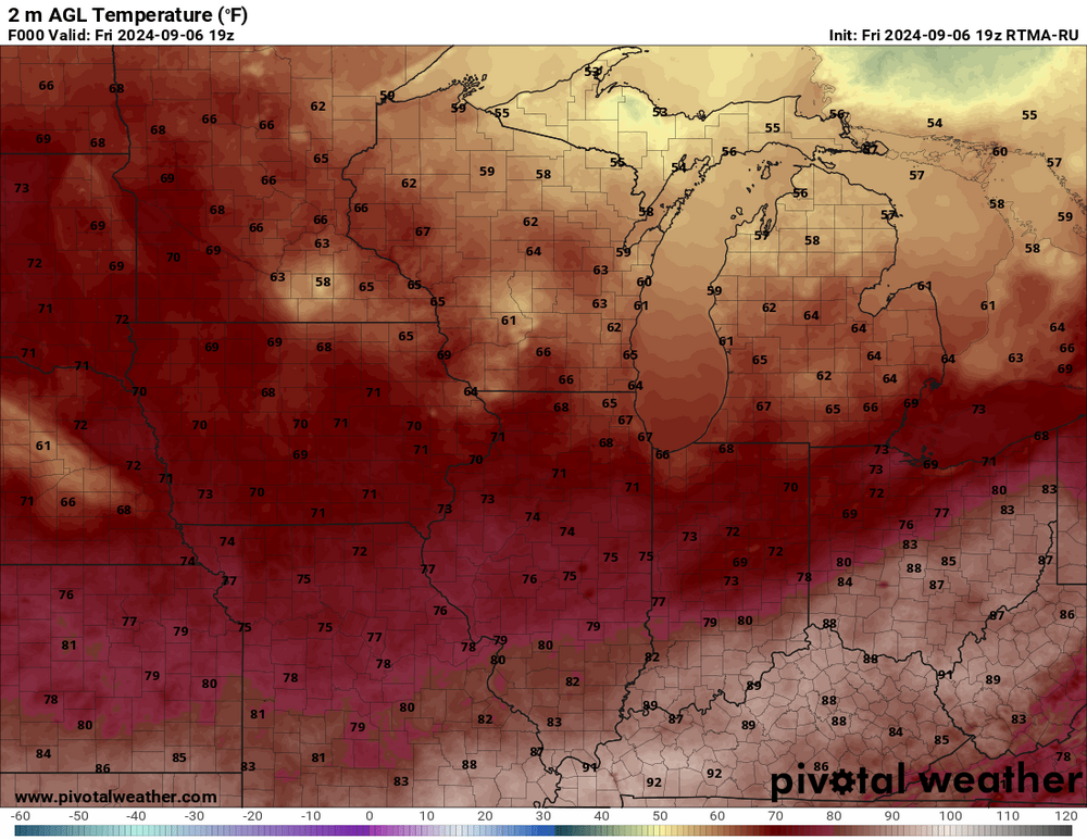
Climbed to 73 here before decaying showers moved through. Wind then turned north northeasterly and low clouds, fog have moved in with the temp of 66. Anything is better than a heat index of 101 like yesterday. I almost bought an AC unit.
- 231 replies
-
- 2
-
-

-
- absolute trainwreck?
- abandon all hope?
- (and 1 more)
-
Received a severe warning during the night with a wind gust to 40 mph and 3/4's an inch of rain. Temps today should remain steady in the upper 60's to near 70. Another decent shot at rain tonight as well. Seasonable temps. After a furious couple weeks at the hummingbird feeder, I noticed the male hummers have already left and the females and babies are sticking around still feeding but much nicer about it. They'll depart in another week or so. I usually leave my feeder up until the 15th of Sept for the lone passerby.
- 231 replies
-
- 3
-
-
- absolute trainwreck?
- abandon all hope?
- (and 1 more)
-
Reached 90 here too. The DP is 77 right now... oppressive. The house foundation, my sidewalks and back patio are all sweating. So are the rocks in the woods.
- 231 replies
-
- 1
-

-
- absolute trainwreck?
- abandon all hope?
- (and 1 more)
-
85/76 currently. Haven't seen muggy weather like this in a long time.
-
October 5th a few years ago I received 5 inches of snow so you could see some . Def check out the 35,000 acres of old growth trees. It's a sight to behold and the incline they're on in spots has to be almost 45 degrees. I haven't been there in the summer since I've lived here but have been a few times in the winter but most of the park and the boundary roads close for the season due to the deep snow.
- 231 replies
-
- 1
-

-
- absolute trainwreck?
- abandon all hope?
- (and 1 more)
-
Mid 60's this morning with dp's in the low 60's making it feel a bit humid. Not a bad look for the last week of met summer. The real heat stays south of the UP. With several cool nights in the 30's and low 40's, certain trees are really beginning to show color. This maple is one of the first of the season each year. Last week of September- first of Oct is usually peak here locally. Things should start looking good in another few weeks. Warmer weather could slow things down but it has been pretty dry the last month so trees may be ready to give it up.

.thumb.jpg.7fb93053cc2eda33760813b02190be47.jpg)
- 231 replies
-
- 3
-
-
- absolute trainwreck?
- abandon all hope?
- (and 1 more)
-
Another cool morning in the UP... had 41 here. Warming trend incoming.
- 231 replies
-
- 2
-
-
- absolute trainwreck?
- abandon all hope?
- (and 1 more)
-
There's for sure been some cool stretches but nothing terribly abnormal. For this area, June averaged -0.6, July +0.5 and August to date is right at average, so fairly seasonable. I would say it's been a very pleasant summer. The coolest night this met summer so far has been 34 and the warmest daytime high 89. There was a total of 24 nights with lows in the 40's and 4 nights in the 30's. Some interior areas have seen 12-15 nights in the 30's and even some summer frost. Another chilly one tonight in the low 40's before a huge warmup late week with mid 80's this weekend into next week. With the shorter days, the cooler nights and the leaves beginning to change, I welcome the late summer warmth. Not ready for full blown fall just yet. Garden is still producing very well even with the sun now sinking below the tree line by 3:30. All the critters (especially deer) that enjoy acorns will have plenty to eat this year. I don't think I've ever seen so many. And mice seem in abundance as well compared to the last few years... go figure.
- 231 replies
-
- 3
-
-
- absolute trainwreck?
- abandon all hope?
- (and 1 more)
-
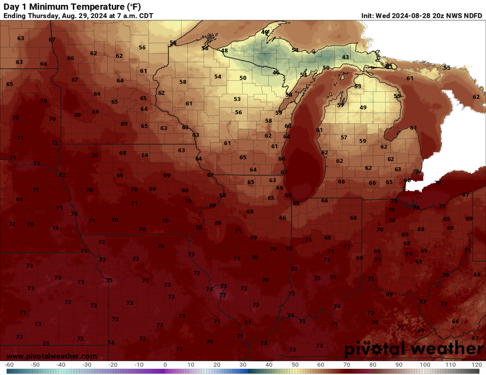
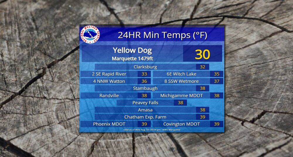
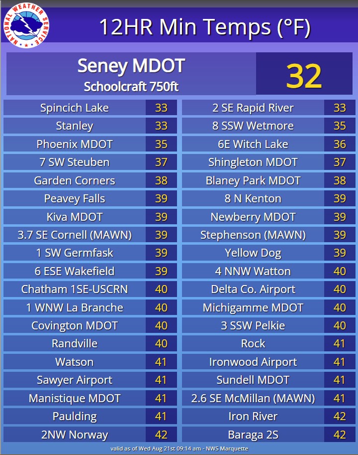
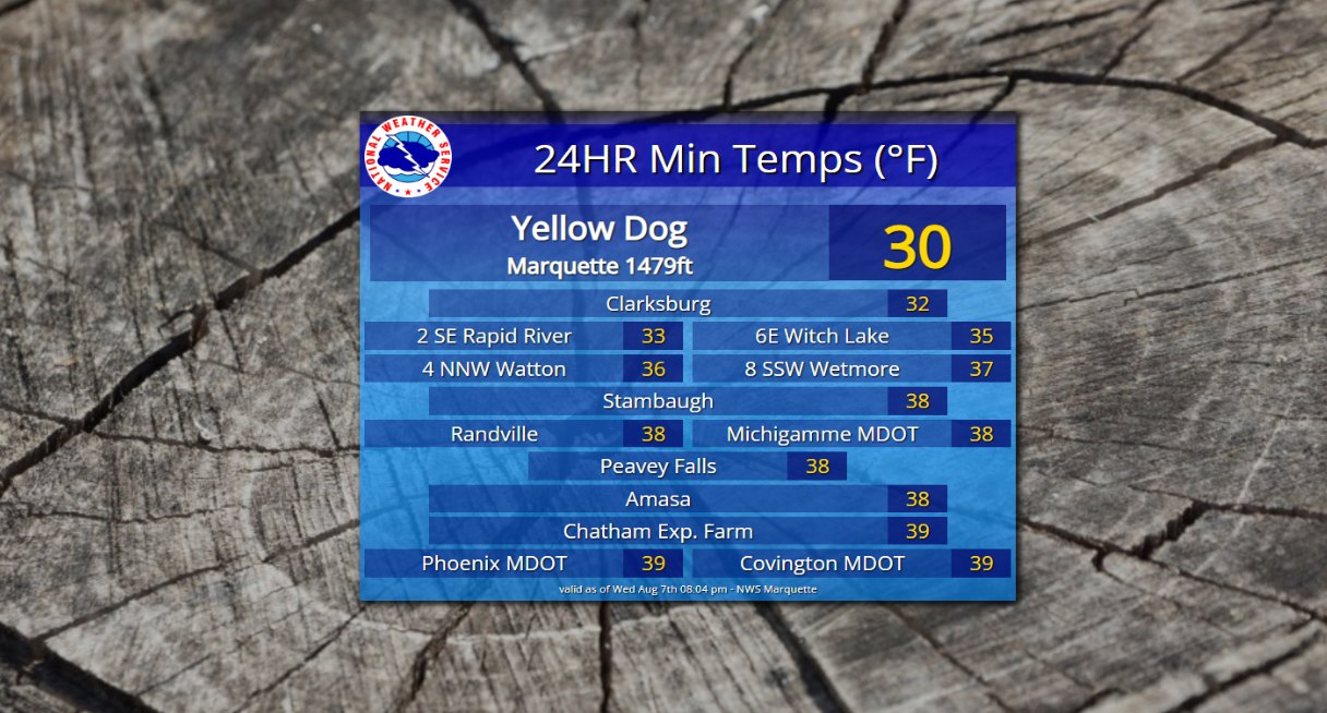
Autumn is def in the air this morning, low of 38. Baraga Plains and Yellow Dog both recorded a low of 30, Champion was 32. Lots of mid to upper 30's away from the shore.
- 231 replies
-
- 3
-
-
- absolute trainwreck?
- abandon all hope?
- (and 1 more)
-
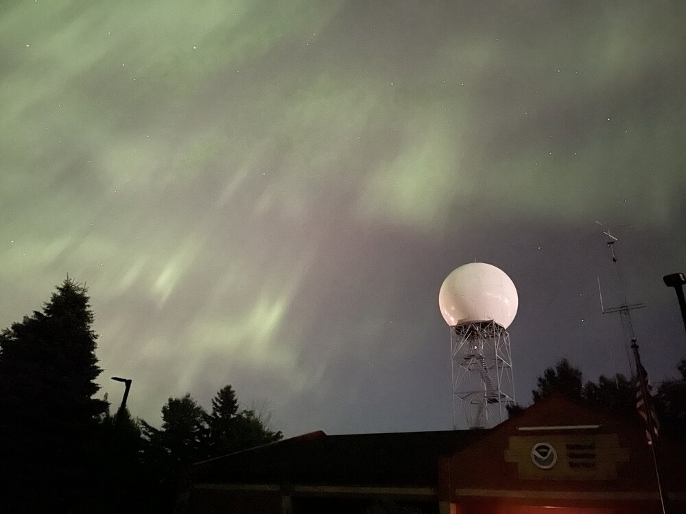
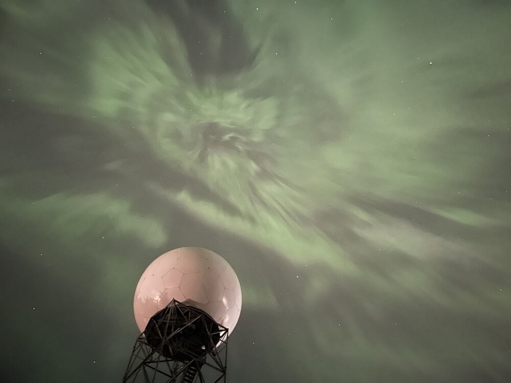
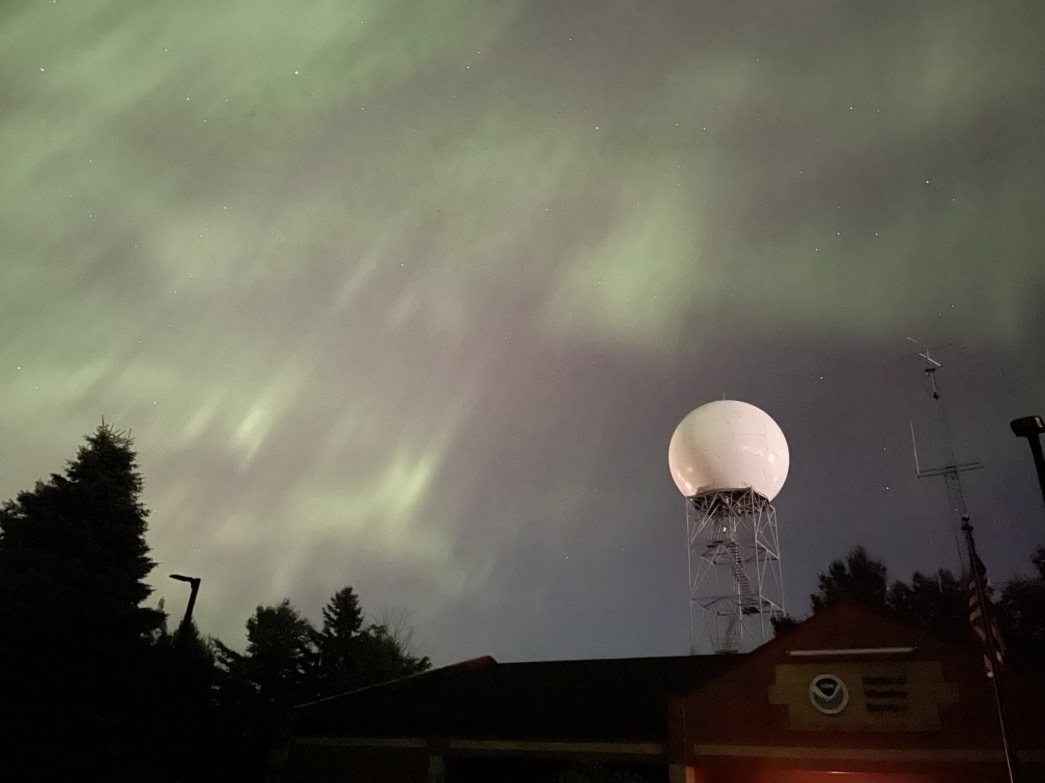
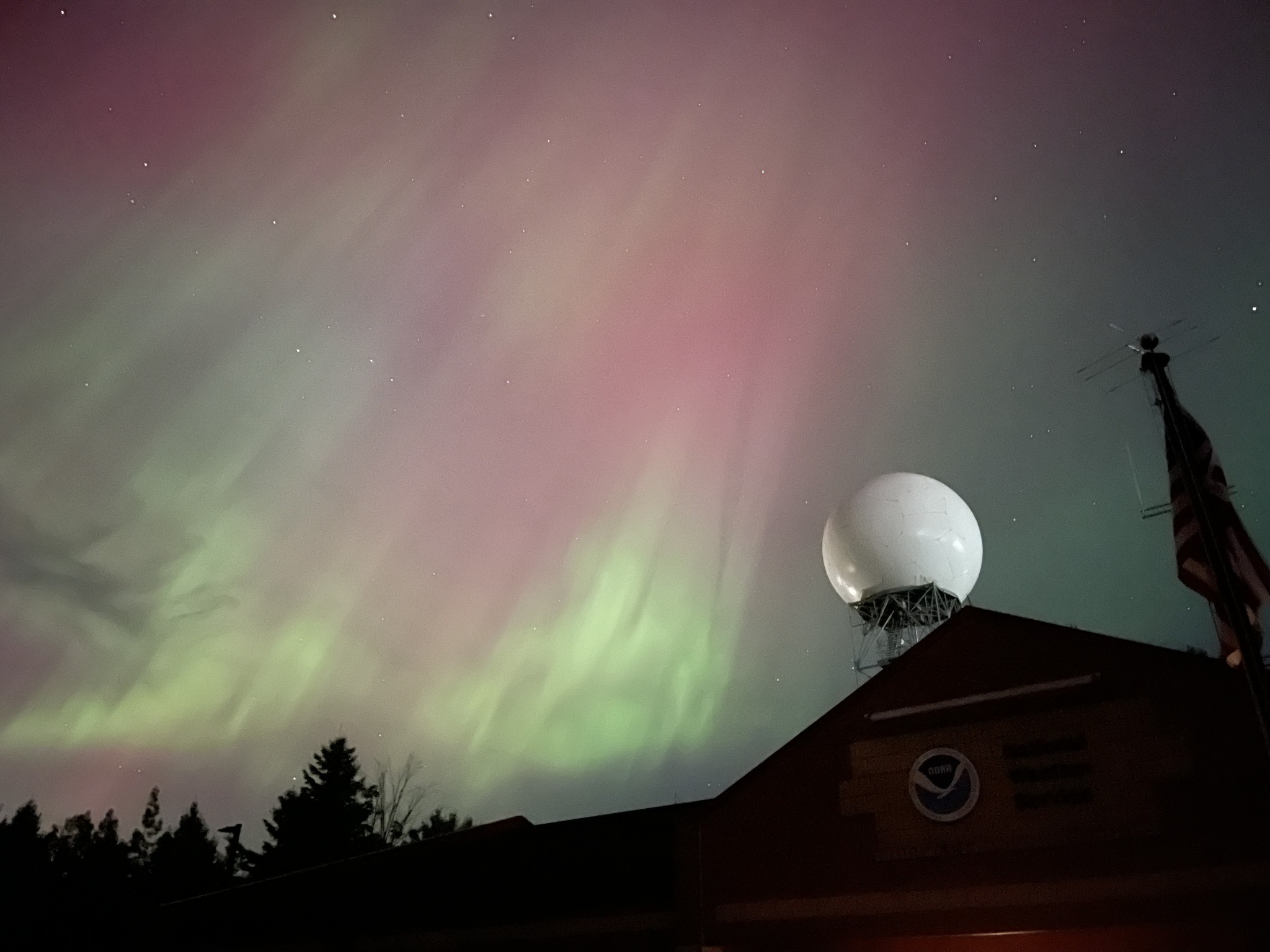
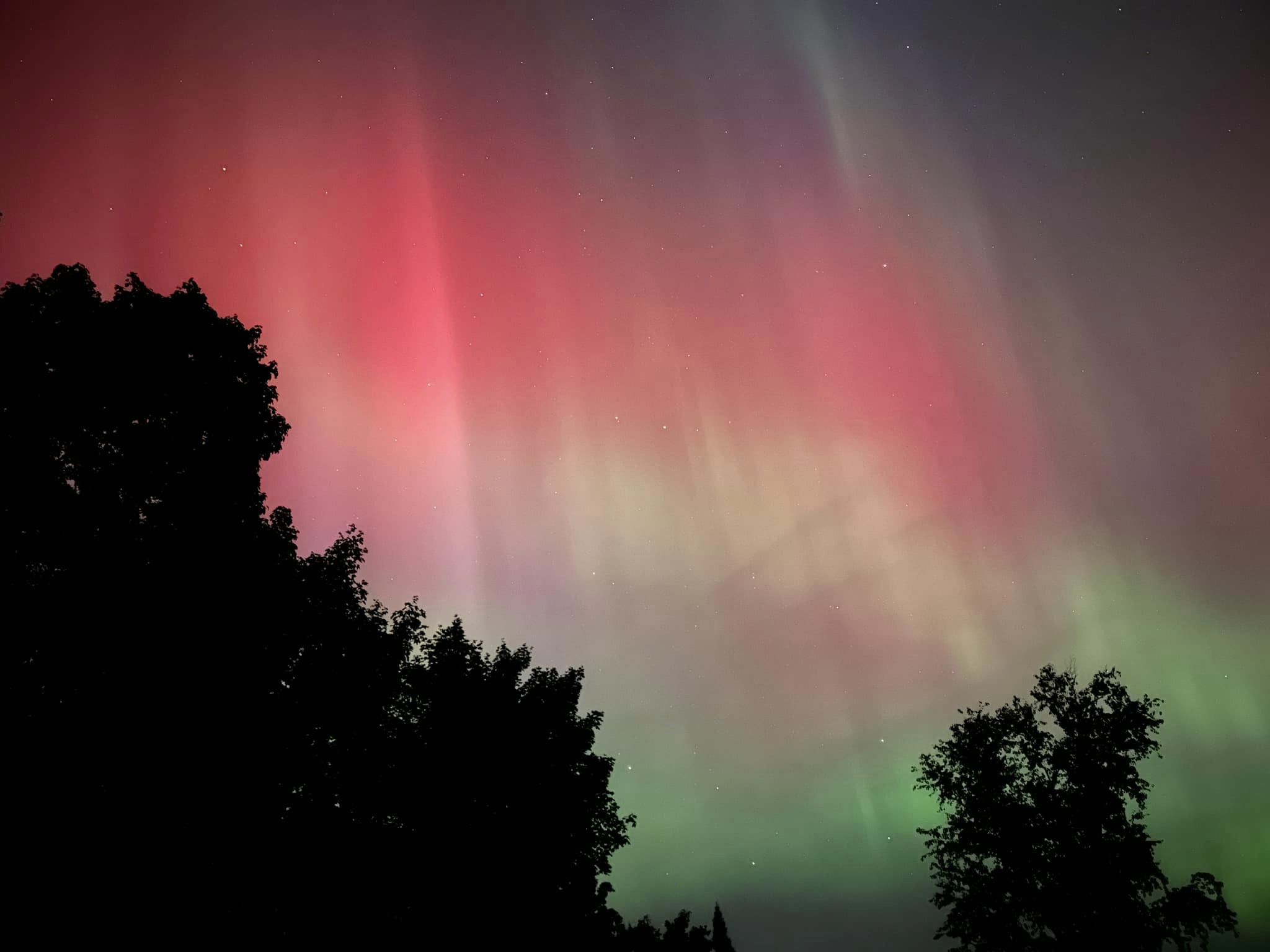
Low of 50, high of 77 today. A beautiful late summer day.... and wow @ the N lights last night. They were very vivid with large pillars and were directly overhead not just the northern sky. Some pics from MQT


- 231 replies
-
- 24
-
-
- absolute trainwreck?
- abandon all hope?
- (and 1 more)
-
Another chilly afternoon in the mid-upper 50's with lake enhanced showers. Things warm up tomorrow to the low-70's but there's def a fall vibe.
- 231 replies
-
- 2
-
-
- absolute trainwreck?
- abandon all hope?
- (and 1 more)
-
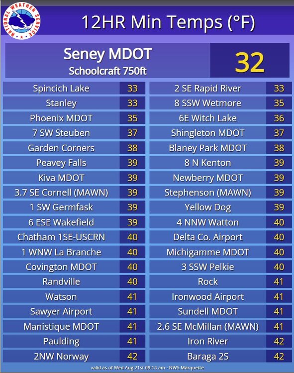
A calm and cool 43 this morning. Just northwest of here at the Yellow Dog RAWS it's 34. Baraga Plains currently 36. Def a taste of what's just around the corner. looks as if the co-op site in Champion, the western part of Marquette County fell to 32 last night. That particular site has seen frost every single month this summer.
- 231 replies
-
- 2
-
-
- absolute trainwreck?
- abandon all hope?
- (and 1 more)
-
Currently 71/48 with steady ne breeze. Point has 46 for tonight with some 30's in the usual spots. Not bad at all for the first week of August.
-

Spring/Summer '24 Banter and Complaint Thread
weatherbo replied to IWXwx's topic in Lakes/Ohio Valley
Snapped this pic today. This is Blossom. A 7 yo doe that was born behind my truck in 2017 along with a twin that did not make it. She hangs in the vicinity of my house for safety and has raised twins here every year except this year. She was pregnant but I never saw her fawns. When I'm out in the garden she comes for her daily cucumber treat. I believe this will be her last summer. Such a sweetie..thumb.jpg.7823100e2e0a41c83df642ae847a92bb.jpg)
- 166 replies
-
- 13
-
-
High of 70 today felt much nicer than the 80's of recent. Hints of fall are popping up here in the north land.
.thumb.jpg.71646e9bf167792b99de69ef112dab71.jpg)
- 231 replies
-
- 2
-
-
- absolute trainwreck?
- abandon all hope?
- (and 1 more)
-
Low overnight was 58. Much better sleeping weather. Currently 67/60... should reach the low 80's with sun and minimal smoke. Not saying it's gonna happen but today could possibly be the last 80 degree temp of August this year.
- 231 replies
-
- 1
-
-
- absolute trainwreck?
- abandon all hope?
- (and 1 more)
-
7th day with temps in the 80's, today being the warmest day of summer with 89. One more day of 80's tomorrow before temps fall back closer to seasonal, and I can't wait. It's been humid, sticky and difficult to sleep at night, even with a fan. Lots of summer left but there's def a late season feel to things.
- 231 replies
-
- 2
-
-
- absolute trainwreck?
- abandon all hope?
- (and 1 more)
-
44 this morning and a pleasant 73 this afternoon. Ready for a week in the low to mid 80's to give the garden the final push it needs the next few weeks before the sun angle begins to fall behind the hill and trees during the late afternoon hours. Lost 2 minutes 18 seconds of sun today and around 20 minutes on the sunset since late June. A few mid 30's reported this morning with 34 being the coolest over in Baraga County and 35 the coolest here in Marquette County.
.jpg.1c946ead3f5a101df7cfae1c9acbb242.jpg)
.jpg.26d5bac19c9aa25a9f5b0f6c4551fa45.jpg)

.jpg.dfa7ab804ac844c5d7f69d24f0aa273d.jpg)

.jpg.c18e077f2622453be211d01eb715dcdb.jpg)
.jpg.fcb9c710ee4b250eb50aa284db7a1c33.jpg)