.jpg.82995912781a8a839ab578c3b293f48f.jpg)

weatherbo
-
Posts
6,475 -
Joined
Content Type
Profiles
Blogs
Forums
American Weather
Media Demo
Store
Gallery
Everything posted by weatherbo
-
Sadly, have only seen one honeybee all Summer. Mostly just bumblebees, and even they are oddly small in size. Of course there's a plethora of wasps and hornets, as usual. Got stung on my hand last week. Do notice a ton of caterpillars this year.
-
Mosquitos and bugs in general have peaked and on a downward trend. August is my favorite month of Summer.
-
It's not just the snowpack, since June 1st MQT has received 5.34" of rain. It did get dry for a week or so in early June but otherwise ground is nice and damp and everything green and lush.
-
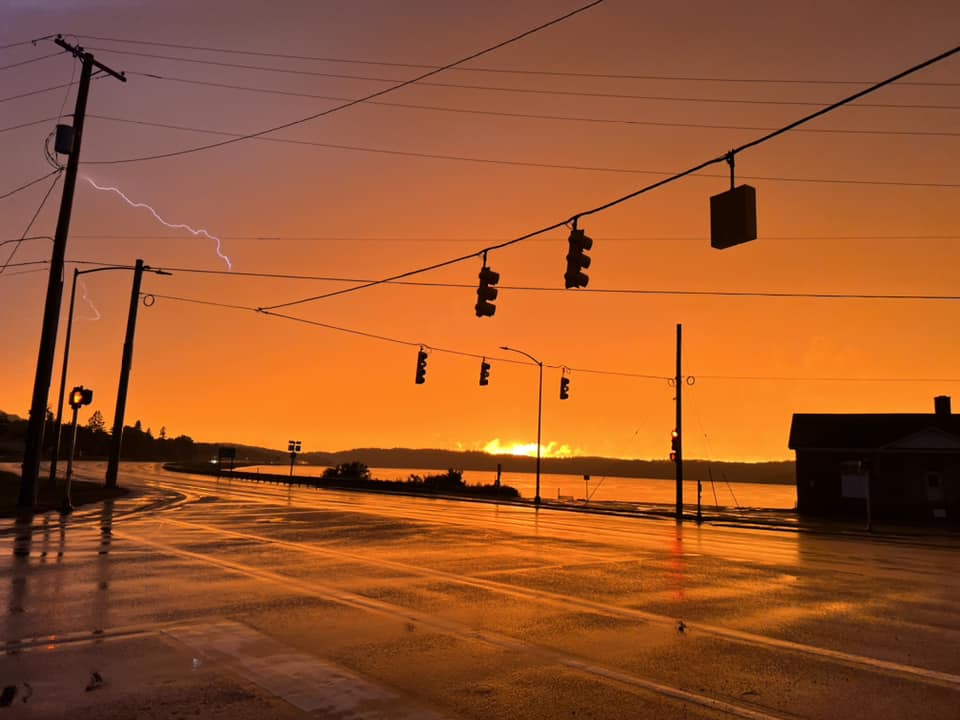
A cool 46 this morning after hvy rainfall and storms. Sunset 7-10-23, Hwy 41 west in Negaunee
- 521 replies
-
- 20
-

-
73 for the high today with showers and storms currently pushing through the area. Looks like near to slightly below average temps with off/on rain chances the next week or so. No complaints.
-
Tad chilly here this morning with a low of 43. Plenty of 30's reported in the interior with the coolest being 32 at Stonington.
-
Even tho where I live is tucked outta the way and not impacted too much by the influx... I still, strongly dislike the tourists!
-
Looks like a decent stretch of weather here the next week with minimal rain, lots of sun and temps in the 70's. Have had 4.23" of rain this month which is around an inch above normal for this area. Most of the UP has avoided any serious dryness with the exception of the far western part.
-
Not to go OT but It's been 8 years since I've had a television and a provider. It was the best decision I ever made.
-
Locally, the smoke isn't near as bad today as the past couple days. I can see haze in the sky but at the surface I don't smell anything. The E UP, however, looks horrible currently.
-
Don't have a television. But I'm not surprised they're pulling something outta their ass.
-
Found this.... prob explains it. Here's why you smell plastic from a forest fire: "Wood fires emit a ton of volitile organic compounds (voc) Most of these VOCs are noticeable to our noses as the familiar "campfire" smell, but they breakdown quickly when exposed to UV radiation from sunlight. Other VOCs like benzene, formaldehyde and acrolein are released and they outlast the "campfire" VOCs. It's these chemical compounds that you're smelling as the smoke wafts around for a few days then settles to the ground and reaches your nose. Thus the plastic chemical smell."
-
The air has a very odd burnt electric/plastic smell. Have never smelled anything like this before with wildfire smoke.
-
Breezy, smokey, and 52 here at noon. A two day rain total of 1.68" brings the monthly total to 3.25". Woods are lush and green.
-
High of 79 today before rain developed and spread across the area couple hours ago. So far .83 and counting. Plenty of rain chances the next couple days with cooler, more seasonable like temps. Can't believe it's almost July.
-
Nice. What area did you visit? Too bad streams and rivers are entering their seasonal lows, especially with the dry stretch. Come back in early Autumn.
-
Here in the boreal woods of the north it's very swampy, even during drier times. On my property alone there's three separate swamps with one being right close to the house. It's always buggy until about mid-august. Some years are just worse than others. High of 83 yesterday and looking like a carbon copy today. Breeze will help.
-
A warm one today cutting firewood, 77/51 already. Ticks, flies, and skeeters out in force. Should top out around 81. The 1.6” of rain last week is a distant memory.
-
Finally some nice summer weather. The next 6 days look to have highs between 80-85 each day. Garden will love the sun and warmth. This year I planted tomatoes, cucs, squash, zucchini, potatoes, onions, 4 different pepper varieties, and lettuces. Always a treat to be able to enjoy summer vegetables during the snowy winter months.
-
Was a great summer day. Sunny and 67 with just a bit of smoke.
-
Mist/fog all day, high of 46. Average high is 72. Legit felt like an Autumn day.
-
41 this morning with only 53 forecast for the high today... alleviates the mosquitos a bit but not a very good growing day.
-
56 degrees this afternoon. Cool and dry has been the rule up this way...three frosts this month. Garden is well behind this time last year. Tomato plants have barely budged in 2 weeks. Thankful for the 1.6" of rain the past couple days tho, it was dry.
-
While 44 is too cold, 84 is too warm… lol The low of 28 last night is hopefully the last freezing temps of the season.
-
Sunny and breezy with a high of 44 today. Needed a hoodie.


