

sferic
-
Posts
2,496 -
Joined
-
Last visited
Content Type
Profiles
Blogs
Forums
American Weather
Media Demo
Store
Gallery
Posts posted by sferic
-
-
00z Ukie shaved off a bit from 12z
-
Remember Joe Witte?
-
 2
2
-
-
24 minutes ago, uncle W said:
I think he retired...
Alan Kasper Retired. In 1980 he invited me to tour the WCBS Ch 2 set and weather office.; that was a thrill
-
3
-
-
Can't wait for the 00Z suite
-
4
-
-
Just now, Rjay said:
Another tick or 2 and LI is rain. This isn't the type of storm that will make everyone happy.
Ok 1/2 of a tick so we can share in the wsw here too
-
I want it a tick or two NW so the majority of us are happy from Long Island to the Catskills
-
 1
1
-
-
@Ericjcrash @snywx @crossbowftw3 Deleware, Sullivan and orange counties represented here; 18z nam way NW Thoughts?
-
@crossbowftw3 @Ericjcrash @snywx Think one of us can get 2 inches tomorrow (2.5) ?
-
-
1:00 AM Heavy Snow Liberty NY 24 inches on the nose...Thinking 30 inches is possible between heavy/ moderate snow bands overnight into tomorrow
-
3
-
-
What was a decaying shrinking band of 1-3 inch an hour snows here in Liberty NY has fired up again to heavy snow after 30 minutes of light to moderate snow
-
1
-
-
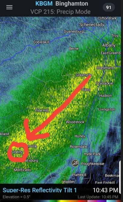
21 Inches on the ground here is the latest radar depiction with Liberty circled in red. Just curious how many more hours will I be under that band
-
3
-
-
10:30 PM Liberty NY 20" OTG 9 of which came in the last 3 hours. That band is sitting right over my house training and back building; would not be surprised if I wind up with 24-30 inches
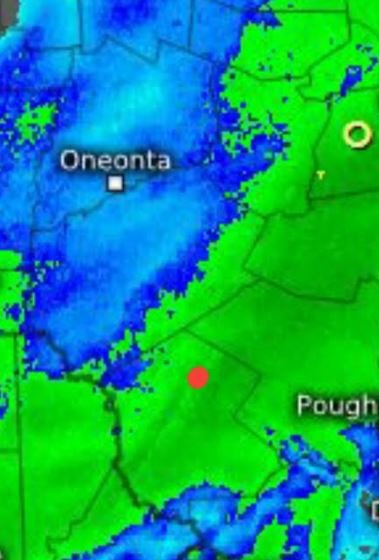
Meanwhile at Lynbrook about 12 inches or so. What is the exact position of the LOW I'm the red dot
-
10:20PM Liberty NY exactly 20 inches OTG HEAVY, HEAVY snow 3 inches an hour and that band like @snywx said parked over Sullivan and back building and training.. Where is the actual low positioned; has it slowed down?
-
3 minutes ago, eduggs said:
A lot of that forecasted snow fell over the past 3 hours I think.
I agree, but it looks according to radar depiction that these insane rates will continue for at least the next few hours.....
-
@snywx Can you post that link tidbits doesnt show double digits
-
9:45 PM Liberty NY Now up to 18 inches and still under that band that keeps back building and training
@snywx @crossbowftw3 @Ericjcrash How are your accumulations and current conditions?
-
Liberty NY 8:30PM 13 inches OTG puking snow 2-3 inches an hour with a band over my area that is training and constantly back building itself
-
Liberty NY 7:20PM Heavy snow 1-2 inches per hour. I am under a band that seems to be training over me ..15 inches possible 11 OTG now
-
Liberty NY 8 inches OTG, hope we make it to a foot @snywx @Ericjcrash @crossbowftw3 Your totals and final accumulation estimates and end time for accum snows
-
-
58 minutes ago, wdrag said:
Hi! Been off line most of the day and back in full early tomorrow. Not much for me to argue... I've no changes to my earlier thinking. In the end it will do what it wants and hopefully I learn from this.
I add two NWS ensemble probability graphics from late today which i think are telling. Note the gradient near NYC on prob >8" so Yes, an easy foot expected in my eyes, but ensembles say don't go all in... since it's on the gradient...30 miles may make a difference between 8 and 20"?
Still the jackpot of 25-30" if it occurs, which i think it will, probably somewhere n of I78 in ne PA, northern NJ and se NYS-Catskills region.
No changes on my concerns about wet snow damage near I95, and coastal flooding, wind gusts 45-55 MPH tomorrow afternoon-eve I95 corridor to the coasts.
Have a good night.


Hoping what Walt said about that 25-30 inch Jackpot in NE PA and Catskills ! @snywx @Ericjcrash @crossbowftw3
-
-
2 minutes ago, nycwinter said:
wabc are accuweather forecasters.. hence why the lower totals..if lee goldberg was in today he might he would be more realistic
So WABC mets have to follow accuweather's script verbatim? They can't progosticate on their own?


2-7-21 Sunday 8-12 hour nor'easter snowstorm roughly 5A-5P
in New York City Metro
Posted
Will look at 00z Euro and see if it caves