

sferic
-
Posts
2,496 -
Joined
-
Last visited
Content Type
Profiles
Blogs
Forums
American Weather
Media Demo
Store
Gallery
Posts posted by sferic
-
-
57 minutes ago, crossbowftw3 said:
Actually, upon further investigation snow ratios should be very favorable tomorrow here inland...talking probably right around 15:1 for a majority of the event. wouldn’t be shocked if someone maxes out between 8-9” in elevations where it stays the coldest longest, with most probably getting 3-6”
Just saw this post, yes indeed
-
2 hours ago, crossbowftw3 said:
Guess we get to do this again tomorrow @sferic probably another 3-4” on top everything we’ve seen in just the last 9 days
yes indeed and more chances down the road too. For tomorrow it's still possible 4-6 is within reason. Waiting for a WWA or WSW perhaps
-
1 hour ago, crossbowftw3 said:
2" here as well, maybe pushing 3
A good line to our west seems promising for another inch
-
1 minute ago, Ericjcrash said:
16° is the temp(colder at my house at lower elevation than up on the hill was 20° on the hill). About a 10" glacier pack
My bad saw that in my mind as inches not degrees; coffee not fully ingested
-
 1
1
-
-
Just now, Ericjcrash said:
Up here Amsterdam 16° with surprising moderate snow. Expected a dusting we'll see. Deleware co. Seems to have been under a good band for a while now.
That 16" recent?
-
Liberty NY 1 inch OTG 24.1 / 11 with Moderate snow. Expecting 2- 3 inches @Ericjcrash @crossbowftw3 @snywx how about you guys?
-
Liberty NY 19.4 / 10
-
5 minutes ago, weatherpruf said:
It's also Saturday night, even if there isn't much to do these days....
so true
-
Liberty NY 22.1/11
-
From BGM
NEAR TERM /THROUGH SUNDAY NIGHT/...
Only minor to temperatures and dewpoints with this update. It
appears that the 18Z model suite for Sunday is trending further
southeast. This will be evaluated for the next update. Previous
discussion below.
-
1 minute ago, lordsnot said:
So DT just cancelled the storm for NY Metro in his final call, just 2-3 inches.
Link?
-
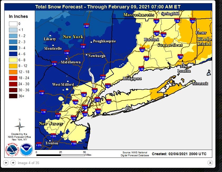
What's with this 6-8 for Sullivan County now ? @crossbowftw3 @Ericjcrash @snywx

-
5 minutes ago, donsutherland1 said:
RGEM=RDPS
Icon is not available.
Thank you once again Don; much appreciated
-
 1
1
-
-
On Pivotal what are the RGEM and ICON labeled as? Thanks!
-
2 minutes ago, mannylovessnow said:
Is that too high for the city?
That's the map as of 3PM
-
I don't think Sullivan county gets 4-6 inches
-
9 minutes ago, snywx said:
1-3" for Sullivan would be my call.. 2-4" in my neck of the woods
Agreed
-
2 minutes ago, snywx said:
BGM is being a bit bullish. 5" is a reach here in Orange
Even more of a stretch for Sullivan
-
14 minutes ago, crossbowftw3 said:
Rather surprisingly, WWA for 3-5 in Sullivan now
Surprising since 18z nam took away as compaed to 12z
-
1 minute ago, donsutherland1 said:
GDPS.
Thank you Don !
-
1
-
-
On Pivotal which model is the equivalent to Tidbits CMC?
-
2 minutes ago, crossbowftw3 said:
If the precip shield can really reach this far N/W, yes, otherwise the 1-3 makes more sense
Which model is favorable to us?
-
16 minutes ago, crossbowftw3 said:
3-6 with iso 8
Really for Sullivan? That's on par with NYC/LI
-
@Ericjcrash @snywx @crossbowftw3 Morning thoughts for our respective areas tomorrow?
Additional 1-5" snow mostly North of I80 Tuesday Feb 9
in New York City Metro
Posted
@Ericjcrash @crossbowftw3 WWA are up for Sullivan and Deleware for up to 7 inches possible