

sferic
-
Posts
2,496 -
Joined
-
Last visited
Content Type
Profiles
Blogs
Forums
American Weather
Media Demo
Store
Gallery
Posts posted by sferic
-
-
12 minutes ago, LibertyBell said:
Thanks! So basically 6-10 for one and 7-15 for the other, nice!
Which second storm and model are you referencing?
-
 1
1
-
-
1 hour ago, crossbowftw3 said:
good to lock in a new snowpack as the pattern will go into remission for the rest of the month
short month !
-
 1
1
-
-
2 minutes ago, crossbowftw3 said:
Watch up for 5-8 in Sullivan. Reasonable. Long duration overall should help this be much easier to keep up with.
If this works out for us and Monday works for us we will have a BIG base. Not too much lost over night into today.
Tonight everything will be frozen rock solid into place into the start of Thursday's even
-
49 minutes ago, Ericjcrash said:
6-12" is a good call, I know it's wide but still...
Plus next Monday's? what a base we'll have
-
@crossbowftw3 @snywx @Ericjcrash Early calls if all goes right? For Sullivan I think 8-12
-
Is all this freezing rain going to encapsulate or shrink my 20 inch base?
-
2 hours ago, crossbowftw3 said:
BGM just issued-only our second ZR event of the winter and like the first one it looks like I may see .25” again. Closer to @sferic could become a skating rink.
...ICE STORM WARNING IN EFFECT UNTIL 10 AM EST TUESDAY...

* WHAT...Significant icing. Additional snow accumulations of up to
  two inches and ice accumulations of two tenths to one half of an
  inch.

* WHERE...In Pennsylvania, Lackawanna, Luzerne, Pike and
  Southern Wayne counties. In New York, Sullivan county.

* WHEN...Until 10 AM EST Tuesday.

* IMPACTS...Power outages and tree damage are likely due to the
  ice. Travel could be nearly impossible. The hazardous conditions
  could impact the Tuesday morning commute.

* ADDITIONAL DETAILS...Ice accumulation in the valley locations
  will range from a tenth to a quarter of an inch...but locations
  above 1500 feet elevation are expected to see as much as one
  half of an inch.
Most definitely; but am more focused with Thursday what are your thoughts?
-
I wonder with rest of 00z suite if low perhaps ticks east
-
Here in Liberty NY it kooks like ice and plenty of it ( half inch likely) . Minimal snow <2 inches with this first event. Later in the week hopefully mainly snow but pure rain up here doubtful
Will look at 00z suite to see if things waffle north or south the nowcasting and HRRR tomorrow
@snywx( Middletown a skating rink ) @Ericjcrash ( you look to be getting the most snow) and @crossbowftw3 you seem to be in the icing camp too
Hopefully end of week storm delivers the good and builds on our base which should stay intact with the freezing and below temps
-
Just now, crossbowftw3 said:
I could probably say a similar theme to tomorrow but not 100% sure yet
As long as my 20 inch base can rise I'd be happy
-
Just now, crossbowftw3 said:
3-6 and icing of up to .25 makes sense at this juncture for tomorrow into Tuesday
How much additional would you guess with the Thursday event?
-
@snywx @Ericjcrash @crossbowftw3 I thing if we wind up with 3-6 inches total by 00z Saturday we'll call it a win. Too much warmth rearing its ugly nose to kill all snow threats through the week thereby greatly lowering the expectations of 12+ for our counties. Agreed?
-
1
-
-
1 hour ago, wdrag said:
First: The GGEM/RGEM are going to win this Monday battle of no precip vs freezing precip occurring. The 06z EC and lesser so GFS, are capitulating to a two part event beginning Monday morning. The 06Z EC gets this going pretty fast before dawn Monday.
I'll get the OBS thread going around 9PM tonight... and to keep it simple, will combine both the front end Monday morning with the primary Monday afternoon-Tuesday morning event. Problems for us will be developing. Added NWS 09z/14 ensembles for .10 glaze and .25" glaze (threshold to begin power outages, the grow much larger when 0.50 glaze ) and added the 5AM view of NWS snowfall expected by Tuesday evening.


Walt, the total snowfall graphic for the NE do you have a link to that graphic? Thank you!
-
4 minutes ago, crossbowftw3 said:
We’re still probably good to go for mostly snow but I wouldn’t be shocked if we see some mixing
I say between 6-12 inches for us by this time next week
-
11 minutes ago, wdrag said:
yes... I 84 itself looks rather light, the EC seemingly a little better than. Yes, they're in the OBS thread once we get it going.
Thank you !
-
 1
1
-
-
7 minutes ago, wdrag said:
Will begin the OBS-NOWcast for the 13th-14th advisory event (already a portion of NJ) at about 5A Saturday, gaining a little more confidence on timing the showery mixed precipitation heading our way. Maybe it will be more stratiform? Think it will begin as a bit of snow or sleet at the start NYC midday-afternoon with maybe a few tenths before any change to freezing rain at night, ending sometime Sunday. nw of I95 there's a small chance of an inch or so of snow-sleet, before any ice.
Walt,
Are North and NW of I84 in the loop?
Thank you !
-
@snywx @crossbowftw3 @Ericjcrash What are your opinions since we span from Delaware Counties to Orange County
-
4 minutes ago, crossbowftw3 said:
The good news is that the storm is in and out by early Wednesday so I would think <.5” for most; still, a very messy time if it were to play out. We just saw what happened in Texas with even <.1”
You don;t see all snow for us with tues-wed ?
-
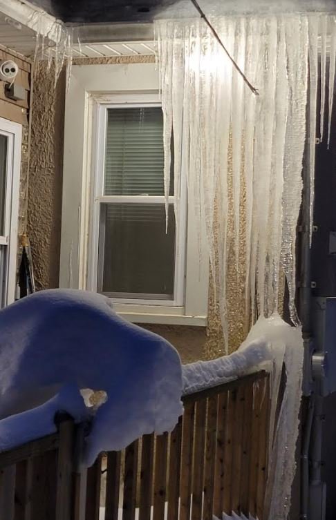
8 minutes ago, North and West said:
Check out the insulation in the spring. You’re likely under insulated at the corners of your roof, allowing heat to escape and melt the under layer of the snow, thus contributing to icicles.
.Valuable info, thanks !
-
10 minutes ago, North and West said:
I’m worried about your gutters.
.Damaged Already !!
-
A glacier is building at my Liberty NY house

-
4
-
-
@snywx @crossbowftw3 @Ericjcrash
Exciting times coming up, how much new snow do you think we'll pick up by next Friday?
Saturday's Storm
Tuesday's Storm
Thursday's Storm
-
1
-
-
@crossbowftw3 @snywx think we get a fresh coating to whiten up the snow pack?
-
1
-
-
@snywx @Ericjcrash @crossbowftw3 Exciting 7 days to come !
-
1
-


Feb 18-19 long duration manageable snow and ice event
in New York City Metro
Posted
100% Correct