CT Rain
-
Posts
25,961 -
Joined
-
Last visited
Content Type
Profiles
Blogs
Forums
American Weather
Media Demo
Store
Gallery
Everything posted by CT Rain
-
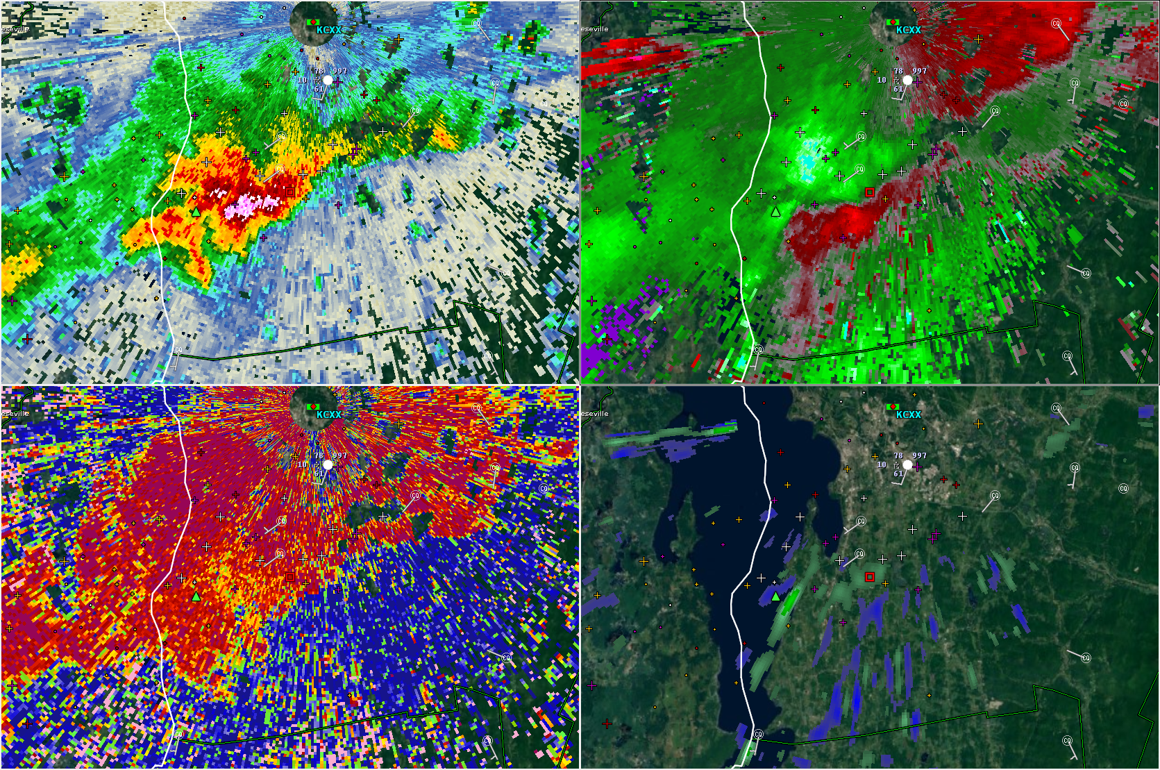
Albany is about to get slammed.
-
Downburst just south of BTV.

-
That one has the strongest mid level meso of the day. Given the amount of beam blockage there it sure could be dropping a tor.
-
Scott's about to rock in Stowe.
-
Anticyclonic tornado in the Berks? lol
-
Yup - I'm surprised the RM fell apart so quickly over NY.
-
You also have 60-70 knots right off the deck. Not going to take much to mix those winds down.
-
Definitely a concerning setup today in N NY and VT. Substantial low level shear, low LCLs, and at least some instability building this afternoon.
-
51 knots HPN
-
38 knots MGJ. Inverted V FTW.
-
That stuff in NY is struggling.
-
It's interesting to watch the change in the models from 48 hours ago to now. The steep mid level lapse rates are clearly not here lol. Decent coverage of downpours though back this way with nice mid level moisture.
-

March 12/13/14 Blizzard/Winter Storm/WWA etc
CT Rain replied to Bostonseminole's topic in New England
This could be a rare upslope event into Litchfield Co CT. It's tough to get it without a good synoptic assist. -
March 12/13/14 Blizzard/Winter Storm/WWA etc
CT Rain replied to Bostonseminole's topic in New England
To be honest, we get so many bad snowfall reports in the media (some intentional, some not) it's easy to toss the outliers at first. -
March 12/13/14 Blizzard/Winter Storm/WWA etc
CT Rain replied to Bostonseminole's topic in New England
Isoplethed this as best we could.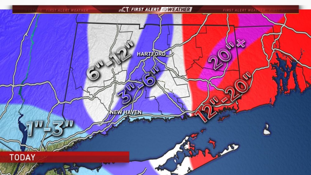
-
March 12/13/14 Blizzard/Winter Storm/WWA etc
CT Rain replied to Bostonseminole's topic in New England
Nice! Where in Scotland? Josh wants to head up there to take some pictures of the jackpot zone. -
March 12/13/14 Blizzard/Winter Storm/WWA etc
CT Rain replied to Bostonseminole's topic in New England
lol you mehd your way to 5" -
March 12/13/14 Blizzard/Winter Storm/WWA etc
CT Rain replied to Bostonseminole's topic in New England
Only 4" on my snow board in WeHa. -
March 12/13/14 Blizzard/Winter Storm/WWA etc
CT Rain replied to Bostonseminole's topic in New England
Yeah woof. That was unpleasant. -
March 12/13/14 Blizzard/Winter Storm/WWA etc
CT Rain replied to Bostonseminole's topic in New England
It's not snowing hard there yet? -
March 12/13/14 Blizzard/Winter Storm/WWA etc
CT Rain replied to Bostonseminole's topic in New England
Mid level magic IMBY. We take. -
March 12/13/14 Blizzard/Winter Storm/WWA etc
CT Rain replied to Bostonseminole's topic in New England
Who knows... maybe an HFD crusher??? -
March 12/13/14 Blizzard/Winter Storm/WWA etc
CT Rain replied to Bostonseminole's topic in New England
Hard to figure out where that western band will setup and pivot. It's definitely scooting east pretty good. Does it continue or does it slow and pivot? Snow is picking up here for sure... probably close to moderate. -
March 12/13/14 Blizzard/Winter Storm/WWA etc
CT Rain replied to Bostonseminole's topic in New England
Only about 1.5" here so far. We were stuck in that subsidence zone earlier. Blah. -
Yeah I guess. I mean have to nod to the mesoscale models so close in. I like the 12z euro TBH... thinking like 12:1 for ratios too?