yoda
-
Posts
63,549 -
Joined
Content Type
Profiles
Blogs
Forums
American Weather
Media Demo
Store
Gallery
Everything posted by yoda
-
Sorry had to clear space for the attachment... added now
-
6z EPS was a good increase for all

-
Super LR 06z GFS - about Day 12 on - sends us to the freezer... highs in the 20s for the rest of the run with lows single digits for most with some teens in metros... looks like some below zero nights Day 14 to Day 16 in the region as well
-
06z GFS says most of us are below freezing for highs on Monday... may stay in the 10s in the mountains and mid 20s for most on Tuesday
-
Looks like 2-4 sounds like a good bet for most ETA: after looking at the 06z NAMs/GFS/RGEM/ICON
-
Good morning AFD from LWX SHORT TERM /THURSDAY THROUGH FRIDAY NIGHT/... Chillier air will filter in behind a cold front Thursday as weak surface high pressure builds overhead. However, the next system will be fast on its heels. A potent jetmax and shortwave in the northern stream of the jet will will dig southeast through the central CONUS and Midwest Thursday. This will carve out an upper-level trough over the Midwest by the end of the day. Surface low pressure will develop well to our south over the southeastern CONUS by the end of the day as well. The shortwave and jetmax will pass through our area Thursday night while the surface low strengthens and tracks northeast through North Carolina Thursday evening and off the North Carolina coast Thursday night. This signal appears to be like a Miller B type low. The track of the shortwave will be far enough to the south to put our area in the favorable region of the mid and upper-level jet for precipitation to develop. Also, there may be added lift from the coastal low, or at least some low-level frontogenetical forcing around 850mb (which can be seen in some of the guidance). There should be enough cold and dry air for the main precipitation type to be snow, and snow is likely to accumulate for most of the CWA. A Winter Storm Watch has been issued for portions of the Potomac Highlands, central Shenandoah Valley, and the Blue Ridge Mountains. As of now, it appears that the best lift associated with this system will set up over these areas, and that will also combine with higher SLR`s (especially over the higher elevations) to enhance snowfall totals. There was consideration for issuing a watch farther northeast toward central VA/southern MD and the Washington DC metro areas. However, lower SLR`s combined with the fact that this is a fast moving system kept confidence below 50 percent for warning criteria to be met. This will be re-assessed later today. However, 2 to 4 inches are most likely across these areas, and that will impact travel, especially overnight Thursday. Farther north across northern MD, eastern WV, and northern VA, accumulating snow is likely across these areas. However, with the better synoptic lift most likely setting up to the south, that kept confidence too low for a watch in those areas at this time. This system will move out of the area by Friday morning, with just some upslope snow showers possible along/west of the Allegheny Front. However, with temperatures below freezing there will be issues with snow covered surfaces that are untreated. Canadian high pressure will approach, and the gradient between the high and the departing low will cause blustery and cold conditions. The high will build overhead Friday night, and winds will diminish but it will be cold.
-
URGENT - WINTER WEATHER MESSAGE National Weather Service Baltimore MD/Washington DC 436 AM EST Wed Jan 5 2022 VAZ025-026-029-504-507-508-WVZ506-051745- /O.CON.KLWX.WS.A.0002.220106T2200Z-220107T1100Z/ Augusta-Rockingham-Page-Eastern Highland- Northern Virginia Blue Ridge-Central Virginia Blue Ridge- Eastern Pendleton- 436 AM EST Wed Jan 5 2022 ...WINTER STORM WATCH REMAINS IN EFFECT FROM THURSDAY AFTERNOON THROUGH LATE THURSDAY NIGHT... * WHAT...Heavy snow possible. Total snow accumulations up to 6 inches possible. * WHERE...Portions of the central Shenandoah Valley and the Blue Ridge Mountains. * WHEN...From Thursday afternoon through late Thursday night. * IMPACTS...Plan on slippery road conditions. The hazardous conditions could impact evening commute Thursday as well as the morning commute Friday. Snow covered and slippery roads are possible.
-
URGENT - WINTER WEATHER MESSAGE National Weather Service Baltimore MD/Washington DC 436 AM EST Wed Jan 5 2022 VAZ503-WVZ505-051745- /O.CON.KLWX.WS.A.0002.220106T2000Z-220107T1500Z/ Western Highland-Western Pendleton- 436 AM EST Wed Jan 5 2022 ...WINTER STORM WATCH REMAINS IN EFFECT FROM THURSDAY AFTERNOON THROUGH FRIDAY MORNING... * WHAT...Heavy snow possible. Total snow accumulations up to 7 inches possible. * WHERE...In Virginia, Western Highland County. In West Virginia, Western Pendleton County. * WHEN...From Thursday afternoon through Friday morning. * IMPACTS...Plan on slippery road conditions. The hazardous conditions may impact travel Thursday night into Friday morning. Snow covered and slippery roads are
-
-
Mmmmhmmm...
-
-
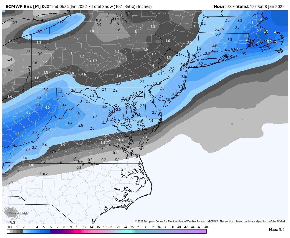
06z GFS is tasty... warning even for most of the region... 4-8"
-
morning AFD from LWX about the "event" Thursday looks to be our next chance at any impactful weather. A emerging shortwave trough will deepen over the Central Plains as a surface low develops over the TN Valley. With the jet stream orientated in a SW to NE trajectory, patten looks indicative for a Miller B type of system: where an emerging low out of the TN/OH valley phases its energy with a developing low off Cape Hatteras. Guidance has been pretty persist on this set- up, resulting in a quick moving snow event. While not expecting amounts to be as drastic as they were yesterday at this time, do think this system is capable of producing a more widespread 1-3" or 2-4" event with locally higher amounts possible along the higher terrain due to upslope processes. Given the fact that this is still a few days away, the forecast is subject to change and confidence on any definitive outcome still remains low at this time. However, confidence is increasing for the possibility of a low end, plowable event. Best estimate for timing at this juncture would be late Thursday night into Friday morning, which would make traveling for the Friday morning commute hazardous.
-
00z EPS through 96 Around 30 of the 50 members have DCA >2" snow
-
Not as good as 12z... but I'd take this run and run lol. Wish it were better yes... but any snow right now is good snow
-
Nice 3-5 for everyone on the 00z CMC
-
I'm surmising that the RGEM would end up being like the 12z EURO if it went out another 6 hours?
-
Upper 20s and snowing at 84 is nice
-
https://forecast.weather.gov/product.php?site=lwx&issuedby=LWX&product=PNS as of 145pm
-
So... Winter Storm Watches by tomorrow afternoon for Thursday into Friday?
-
12z EPS out yet? lol
-
O/U DCA 20 tonight? I'm going with the over... 22 degrees for the low. Cause you know DCA has to mess something up lol
-
Latest PNS from LWX https://forecast.weather.gov/product.php?site=lwx&issuedby=LWX&product=PNS
-
I saw some 6"+ reports... trying to confirm ETA -- Culpepper itself had 8"
-
looks like 6-10