

yoda
-
Posts
59,590 -
Joined
Content Type
Profiles
Blogs
Forums
American Weather
Media Demo
Store
Gallery
Posts posted by yoda
-
-
vere Weather Statement National Weather Service Norman OK 757 PM CDT Thu May 23 2024 OKC055-065-075-141-240115- /O.CON.KOUN.TO.W.0127.000000T0000Z-240524T0115Z/ Jackson OK-Kiowa OK-Tillman OK-Greer OK- 757 PM CDT Thu May 23 2024 ...A TORNADO WARNING REMAINS IN EFFECT UNTIL 815 PM CDT FOR CENTRAL JACKSON...SOUTH CENTRAL KIOWA...NORTHWESTERN TILLMAN AND SOUTHEASTERN GREER COUNTIES... At 757 PM CDT, a storm with a history of significant tornadoes was just southwest of Altus, moving northeast at 20 mph. An additional tornado was located between Altus and Duke with erratic motion. HAZARD...Damaging tornado and tennis ball size hail. SOURCE...Broadcast media confirmed tornado. IMPACT...Flying debris will be dangerous to those caught without shelter. Mobile homes will be damaged or destroyed. Damage to roofs, windows, and vehicles will occur. Tree damage is likely. Locations impacted include... Altus, Olustee, Martha, Headrick, Friendship, Altus Air Force Base, Humphreys, and Duke. PRECAUTIONARY/PREPAREDNESS ACTIONS... To repeat, a tornado is on the ground. TAKE COVER NOW! Move to a storm shelter, safe room, or an interior room on the lowest floor of a sturdy building. Avoid windows. If you are outdoors, in a mobile home, or in a vehicle, move to the closest substantial shelter and protect yourself from flying debris. && LAT...LON 3455 9954 3467 9957 3474 9953 3477 9908 3447 9916 TIME...MOT...LOC 0057Z 248DEG 18KT 3462 9937 TORNADO...OBSERVED MAX HAIL SIZE...2.50 IN -
1 minute ago, Kmlwx said:
If @Amped is excited - that's usually a good indication for severe.
18z GFS looks like a significant severe weather episode for us Monday afternoon/evening
-
12 minutes ago, Kmlwx said:
Using MBY in Silver Spring/Colesville as a point, the IEM SPC Outlook filtering guide shows *TEN* moderate risk days from May to October in 1990. Obviously, meteorology wasn't advanced as it was...but that was either a heck of a bust year or we were absolutely getting rocked and rolled. I wasn't born yet

I will have to look it up after I get home from work... and I was 3 years old
-
BULLETIN - IMMEDIATE BROADCAST REQUESTED Severe Thunderstorm Warning National Weather Service State College PA 535 AM EDT Thu May 23 2024 The National Weather Service in State College PA has issued a * Severe Thunderstorm Warning for... Southeastern Centre County in central Pennsylvania... North central Juniata County in central Pennsylvania... Northeastern Mifflin County in central Pennsylvania... Snyder County in central Pennsylvania... Union County in central Pennsylvania... * Until 615 AM EDT. * At 532 AM EDT, a severe thunderstorm was located over Poe Valley State Park, moving east northeast at 50 mph. HAZARD...70 mph wind gusts and penny size hail. SOURCE...Radar indicated. IMPACT...Expect considerable tree damage. Damage is likely to mobile homes, roofs, and outbuildings. Numerous reports of downed trees have occurred with this storm over the past 30 minutes * Locations impacted include... Mifflinburg, Woodward, Burnham, Milroy, Highland Park, Middleburg, Yeagertown, McClure, Kreamer, Penns Creek, Beaver Springs, and Reedsville. PRECAUTIONARY/PREPAREDNESS ACTIONS... This is a dangerous storm. To stay safe, immediately move inside a well built structure and stay away from windows. This thunderstorm is capable of producing all types of severe weather including large hail, destructive straight line winds and tornadoes. Move quickly to a safe shelter such as an interior room, a bathroom, closet or basement. Frequent cloud to ground lightning is occurring with this severe thunderstorm. Move indoors immediately. Lightning is one of nature`s leading killers. Remember, if you can hear thunder, you are close enough to be struck by lightning.-
 1
1
-
-
From this mornings AFD regarding Monday... already tossing out the significant severe weather episode words
LONG TERM /SUNDAY THROUGH WEDNESDAY/...

Shortwave ridging will build again on Sunday keeping convective
cvrg isolated and mainly along the I-64 corridor.

Memorial Day still looks like a very active severe wx day and
the most active of all of next week. A deep upper level trough
over the Great Lks region will push a strong cold front through
the area Monday evening. Ahead of this front, widespread showers
and thunderstorms appear definite with the potential for a
significant severe wx episode given moderately strong bulk shear
values of 30-40kt, high instability, and moderately steep mid-
level lapse rates. GFS forecast soundings also indicate a
tornado threat with 0-3 km SRH of over 200 m^2/s^2, EHI of 2-4,
and high supercell composite values. The severe threat should
end by 06Z Tue with frontal passage. There could still be
instability showers Tue afternoon as upper trough axis pivots
through, but the deep moisture should have been shunted south
and east the night before.
-
2
-
-
MCD out for our far NW zones
https://www.spc.noaa.gov/products/md/md0891.html
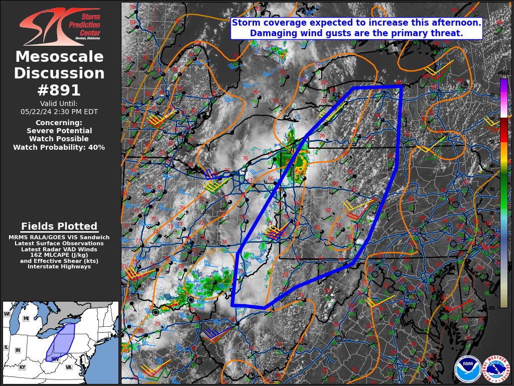
Mesoscale Discussion 0891
   NWS Storm Prediction Center Norman OK
   1128 AM CDT Wed May 22 2024

   Areas affected...Western New York into parts upper Ohio Valley

   Concerning...Severe potential...Watch possible

   Valid 221628Z - 221830Z

   Probability of Watch Issuance...40 percent

   SUMMARY...A severe thunderstorm watch is possible for parts of
   western/central New York into the upper Ohio Valley. Damaging winds
   will be the primary threat. An isolated brief tornado and large hail
   may occur with the stronger, more organized activity.

   DISCUSSION...Convection has been most intense right ahead of an MCV
   tracking into northwest Pennsylvania and southwestern New York.
   Destabilization continues to occur ahead of this activity and
   farther south into western Pennsylvania and vicinity. Convection is
   likely to continue in close proximity to the MCV as well as
   additional development within the Allegheny Mountains. Buoyancy may
   be more limited into southeast Ohio/northern West Virginia due to
   cloud cover. Observed morning soundings from the region showed
   mid-level lapse rates around 7 C/km. Deep layer shear this far east
   will be weaker given the displacement from the primary synoptic wave
   in the Upper Midwest. However, some modest increase in shear should
   occur through the day. Storms will be capable of damaging winds
   primarily. Some risk for a brief tornado is also evident given
   modest low-level hodograph turning on area VAD profiles. Large hail
   could occur with the strongest storms, but weak upper-level flow
   will likely keep this threat more isolated. A watch may eventually
   be needed should convective trends warrant.

   ..Wendt/Hart.. 05/22/2024

   ...Please see www.spc.noaa.gov for graphic product...

   ATTN...WFO...BGM...BUF...CTP...LWX...PBZ...RLX...CLE...
-
SPC has nudged the eastern extent of the MRGL risk to the i95 corridor on the 1630z OTLK
-
12z NAM NEST and 12z NAM look decent around 6 to 8pm
13z HRRR is nice as well, stormy for the region after 22z to the end of its run
-
2
-
-
Morning disco talking up tomorrow potential and Memorial Day
.SHORT TERM /THURSDAY THROUGH FRIDAY NIGHT/...
Stronger forcing for ascent will move into the area Thursday
attendant to an upper trough and strong surface cold front
approaching from the Midwest. Cloud debris and the front
approaching during the early part of the peak heating window
casts some uncertainty to the extent of instability. But, with
stronger forcing and shear, there is at least a conditional risk
for more organized strong to severe thunderstorms. It remains to
be seen just how widespread the threat is, but storms may tend
to focus further south and east toward the I-95 corridor where
the potential for heating will last longest.

Trends will need to be closely monitored over the next 24 hours,
as upstream convection over the Midwest will dictate subtle
shifts in (1) vort maxes embedded in the large scale flow, and
(2) the extent of cloud debris that could inhibit heating.

The front itself likely stalls to the north, but a wind shift or
pre-frontal trough type feature should shift south Thursday
night. Given the front(s) nearby, and lingering troughing and
moisture, shower activity could last well into the night.

Additional waves along the stalled front may lead to an
unsettled Friday, as well. Although forcing and instability look
to be a bit less, shower and thunderstorm potential will still
be there especially further south near the I-64 corridor closer
to the wind shift. It does not look like it will rain the entire
day, but rather the potential for showers and thunderstorms will
linger, with chances cresting during peak diurnal heating.

&&

.LONG TERM /SATURDAY THROUGH TUESDAY/...

The weather pattern over the Memorial Day holiday weekend will
be characterized by gradually lowering heights and surface
pressures leading to a stormy pattern. Saturday should turn out
rather active due to a low amplitude shortwave trough moving
across the area that should act to enhance t-storm activity.
Sunday appears to be the least active day due to shortwave
ridging and some drying. Severe weather risk appears to increase
markedly on Memorial Day due to strengthening wind fields aloft
and strong shortwave energy moving across the area around the
base of a deep upper level trough over the eastern Great Lks. A
strong cold front will follow Monday night bringing cooler and
drier conditions for the middle of next week.
-
2
-
-
SPC day 4 to 8 OTLK has a mention
   ...Days 6-8/Mon-Wed...

   Spread among model guidance increases quite a bit by Monday. Some
   severe potential is possible anywhere from the Southern states to
   the Mid-Atlantic as the upper trough lifts east/northeast. However,
   details regarding storm evolution on Day 5/Sun into early Monday,
   along with differing evolution of the surface pattern by various
   guidance results in low predictability.

   By Tuesday and Wednesday, an upper ridge is expected to move from
   the western U.S. into the Plains. This should mostly shut down
   severe potential west of the MS River.
-
National Weather Service Baltimore MD/Washington DC
409 AM EDT Wed May 22 2024

ANZ530>543-DCZ001-MDZ008-011-013-014-016>018-504-506-508-
VAZ053>057-527-230815-
Chesapeake Bay north of Pooles Island MD-
Chesapeake Bay from Pooles Island to Sandy Point MD-
Chesapeake Bay from Sandy Point to North Beach MD-
Chesapeake Bay from North Beach to Drum Point MD-
Chesapeake Bay from Drum Point MD to Smith Point VA-
Tidal Potomac from Key Bridge to Indian Head MD-
Tidal Potomac from Indian Head to Cobb Island MD-
Tidal Potomac from Cobb Island MD to Smith Point VA-
Patapsco River including Baltimore Harbor-
Chester River to Queenstown MD-Eastern Bay-
Choptank River to Cambridge MD and the Little Choptank River-
Patuxent River to Broomes Island MD-
Tangier Sound and the inland waters surrounding Bloodsworth
Island-District of Columbia-Cecil-Southern Baltimore-
Prince Georges-Anne Arundel-Charles-St. Marys-Calvert-
Central and Southeast Montgomery-Central and Southeast Howard-
Southeast Harford-Fairfax-Arlington/Falls Church/Alexandria-
Stafford-Spotsylvania-King George-
Central and Southeast Prince William/Manassas/Manassas Park-
409 AM EDT Wed May 22 2024

This Hazardous Weather Outlook is for the Maryland portion of the
Chesapeake Bay, Tidal Potomac River, and I-95 corridor through
central Maryland, northern Virginia, and District of Columbia.

.DAY ONE...Today and Tonight

Widely scattered thunderstorms are forecast this afternoon and
evening. A couple isolated severe thunderstorms with damaging wind
gusts and hail are possible, mainly between 6 PM and 10 PM.

Thunderstorms may also produce hazardous winds and waves over area
waterways late this afternoon and evening.

.DAYS TWO THROUGH SEVEN...Thursday through Tuesday

Scattered to numerous thunderstorms are likely Thursday afternoon
and early evening. A few storms may be severe with damaging wind
gusts and large hail.

Daily thunderstorm chances are forecast through the upcoming
holiday weekend. A few storms may be severe during the afternoon
and evening hours, particularly Saturday and Monday.

.SPOTTER INFORMATION STATEMENT...

Spotter activation may be needed at times.
-
LWX mentions very isolated threat tomorrow, chance on Thursday, and then possibly substantial on Monday in the morning AFD
Deep layer shear is expected to remain weak Wednesday (AOB 20
kts sfc-500 hPa). However, flow will increase subtly later in
the day, and heights will begin to come down slightly as well.
This, coupled with above normal temperatures and increasing
humidity and instability will lend to a threat of at least
widely scattered showers and thunderstorms come afternoon. The
threat appears greatest west of I-95 further away from the
departing ridge and any associated subsidence. A couple storms
could produce a little hail or gusty winds given the increased
instability, but the lack of shear will probably keep a more
organized or widespread severe weather threat marginal, and
relegated to north of US-33/west of US-15 for the most part.

Heights fall more appreciably on Thursday as a surface cold
front impinges on the area. Latest guidance times the front
favorably with peak heating. The background airmass will be very
warm and humid, but cloud debris from previous day`s convection
over the middle of the country could inhibit more significant
CAPE. If higher instability is realized, a more organized threat
for strong to severe thunderstorm clusters could develop given
the strong surface front and increasing flow/shear aloft in the
right entrance region of a seasonably strong upper jet. The
threat for strong to severe thunderstorms may be greater south
of US-50/I-66 and east of US-15 where the potential for more
heating is highest.

Activity should gradually dissipate heading into Thursday night
as daytime instability wanes and the front sags south. But, the
front`s progress will be slow, so the potential of showers may
linger well into the night south of US-50/I-66.

&&

.LONG TERM /FRIDAY THROUGH MONDAY/...

A front will remain generally north of the Pennsylvania Turnpike
through early next week keeping the local area in a warm and humid
air mass with the risk of almost daily afternoon and early evening
showers and thunderstorms. A well defined 700 mb shortwave-trough is
fcst to approach the area Fri night with its axis crossing the area
around 18Z Saturday. With shear vectors on the weaker side and slow
storm motions, storms Fri afternoon and evening may pose a risk of
heavy rainfall and flash flooding. Saturday`s threat really depends
on the timing of that shortwave as it appears the trough axis will
be too far east to enhance t-storm activity.

On Sunday, the models show significant 925-850 mb drying under low-
mid level ridging, which is likely to keep t-storm activity isolated
at best.

On Monday, a potent shortwave-trough and attendant sfc cyclone will
move across Ohio and northern Mid-Atlantic. This system could pose a
more substantial severe wx threat given strong winds aloft
especially if the timing of the frontal passage coincides with
peak heating. The latest timing suggests a severe threat
during the morning hours, but things could definitely still
change between now and next Monday.
-
Thursday sounds interesting... from this mornings AFD
.LONG TERM /THURSDAY THROUGH SUNDAY/...
To the south of a deep upper trough tracking across Quebec will
be a series of lower amplitude waves that race toward the Mid-
Atlantic region on Thursday. As this occurs, a slow moving cold
front is expected to push through the local area by midday into
the evening hours. There is fairly strong mid/upper support with
a belt of 500-mb west-southwesterlies around 40 to 50 knots.
This is accompanied by ample right entrance region jet dynamics
within a jet streak running between 100 to 110 knots. The key
parameter that will dictate the degree of severe weather threat
is the instability. At this point, even global ensembles are
showing around 1,000 to 1,500 J/kg of surface-based CAPE on
Thursday. This would be more than adequate to support severe
convection given the extent of vertical shear in the profile.
However, as usual, the near to short term trends of cloud cover
which inhibits convective potential will need to be monitored
ahead of the event. Besides the threat for showers and
strong/severe thunderstorms, it should be a very warm day with
decent humidity owing to persistent south-southwesterlies.
Forecast highs are in the mid/upper 80s, with heat indices
approaching the low 90s. The frontal boundary eventually slides
off to the south by Friday morning.
-
4
-
-
What's going on in Cecil county? Never seen this before from LWX
BULLETIN - EAS ACTIVATION REQUESTED
Law Enforcement Warning
MD Cecil County Department of Emergency Services
Relayed by National Weather Service Baltimore MD/Washington DC
622 AM EDT Mon May 20 2024

...Law Enforcement Warning...

The following message is transmitted at the request of CCSO.

Police activity in the area. Please stay indoors. There is
currently no threat to the public.

$$

OnSolve-e9a5f08051364d648cad1bae12903c97/MD Cecil County
Department of Emergency Services
-
LWX hinting at chance of severe next week in their afternoon AFD
LONG TERM /TUESDAY THROUGH SATURDAY/...
A broad upper level ridge is forecast to be remain in place over the
eastern seaboard on Tuesday with high pressure at the surface. A
southerly return flow will lead to increasingly warming
temperatures through the middle parts of next week. The SFC high
pressure on Tuesday will keep the region dry, but an approaching
cold front from the west will bring increasing chances for showers
and thunderstorms Wednesday through Friday. Model guidance has
trended slower with the mid-week system and there remains some
uncertainty if there will be enough instability (CAPE) that overlaps
with the favorable period for shear to produce a threat for severe
weather. SPC is focusing on the Ohio Valley for SVR weather
Wednesday into Thursday, but the CIPS machine learning model
continues to suggest that there is a chance for isolated severe
weather in our region during the middle and later parts of next
week.
-
Been pouring the past hour here
-
9 hours ago, Jrlg1181 said:
Yeah and my expectations of a another dud is looking more like the usual reality... Will see later 2nght if any legit rain occurs...
Looks like its raining down there
-
-
-
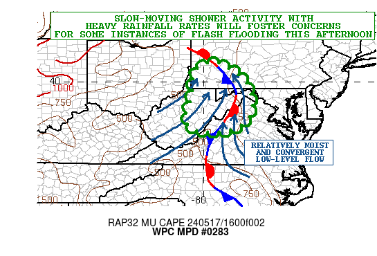
https://www.wpc.ncep.noaa.gov/metwatch/metwatch_mpd_multi.php?md=0283&yr=2024
Mesoscale Precipitation Discussion 0283
NWS Weather Prediction Center College Park MD
135 PM EDT Fri May 17 2024

Areas affected...Portions of the Central Appalachians/Blue Ridge

Concerning...Heavy rainfall...Flash flooding possible

Valid 171735Z - 172335Z

SUMMARY...Slow-moving shower activity with heavy rainfall rates
will tend to increase in coverage this afternoon across areas of
the central Appalachians including parts of the Blue Ridge. This
coupled with moist antecedent conditions will promote a threat for
some instances of flash flooding.

DISCUSSION...A broad mid to upper-level trough over the OH Valley
will continue to move gradually off to the northeast today toward
the central Appalachians. Some generally weak DPVA/forcing
associated with this will be interacting with modest
diurnally-enhanced instability and a relatively moist airmass for
broken areas of heavy showers.

Radar imagery already shows some locally heavy shower activity
impacting areas of southeast OH into southwest PA and down through
central WV as the leading edge of relatively stronger forcing
aloft arrives. Some expansion of this activity with a general
increase in rainfall rates can be expected this afternoon as
MUCAPE values increase to locally over 1000 J/kg and couple with
smaller scale areas of more targeted moisture convergence in
vicinity of a quasi-stationary front draped over the higher
terrain.

Relatively moist southeast flow will also provide a localized
orographic component to the rainfall threat with southeast-facing
slopes of the central Appalachians and portions of the Blue Ridge
seeing pockets of more focused low-level forcing for slow-moving,
but heavy shower activity.

The rainfall rates should be efficiently high given the overall
depth of moisture through the vertical column which was evidenced
in 12Z RAOB data across the broader OH Valley this morning in
connection to the aforementioned trough. The modest increase in
instability will favor some shower activity capable of producing
rainfall rates of 1 to 1.5 inches/hour with the stronger cells.

Given the overall weak steering flow, and orographic nature of
some of the convection, there may be a sufficient level of
persistence to the showers to yield some excessive totals. This is
being supported by the 12Z HREF guidance which suggests some of
the heavier rates focusing over parts of southwest PA through the
eastern WV/MD panhandles and northwest VA in vicinity of the Blue
Ridge. Some spotty 2 to 3+ inch rainfall totals will be possible
by early this evening, and with moist antecedent conditions/lower
FFG values in place, some instances of flash flooding will be
possible.

Orrison

ATTN...WFO...CTP...LWX...PBZ...RLX...RNK...
-
5 minutes ago, TSG said:
I cursed us. I'm sorry.

-
Meanwhile in Houston
 33 minutes ago, WxWatcher007 said:
Grid demolished. Over a million outages statewide and 40% of Harris County without power.
-
Needed rain
Heading into Saturday, a stronger shortwave moves into the
southeast to pick up the stalled warm frontal boundary.
Continued shower and thunderstorm activity is expected through
day Saturday. Isolated flooding continues to be a concern with
repeated rounds of slow moving showers. Around 1-2 inches of
rain are expected through the duration of the weekend. Some
areas could see closer to 2.5 inches, but confidence on exactly
where is low as it depends on where the boundary will be Friday
night into Saturday. For now, highest estimates are in portions
of the Shenandoah Valley and Virginia Piedmont. Shower and
thunderstorm coverage decreases through Saturday evening as the
low moves off to the southeast, but rain likely continues into
Sunday.
-
LWX mentions Wednesday as next chance for some severe storms in the afternoon AFD
Fairly potent system approaches the area by Wednesday, with a cold
front advanced out ahead of the system. Guidance has been hinting at
the opportunity for increased instability ahead of the frontal
passage. Could see some thunderstorms develop, with some getting
strong to severe. Still a lot of uncertainty with this system with
respect to timing and intensity. Highs on Wednesday will be in the
upper 70s to low 80s.
2024 Severe Weather General Discussion
in Mid Atlantic
Posted
Looks like there were a few LSRs of ping pong ball sized hail this afternoon... one on Shenandoah county; the other in Loudoun just NW of IAD