

yoda
-
Posts
59,444 -
Joined
Content Type
Profiles
Blogs
Forums
American Weather
Media Demo
Store
Gallery
Posts posted by yoda
-
-
Storms entering NW VA increasing in intensity and some hail cores slowly starting to appear
-
1630z disco
.Lower OH Valley into the Mid-Atlantic states...
   Morning surface mesoanalysis places a residual frontal zone draped
   over central IN/OH with a low-level moisture reservoir (low 60s deg
   F surface dewpoints) extending from the confluence of the MS/OH
   rivers northeastward into the lower Wabash Valley.  Atop this
   moisture, a plume of steep 700-500 mb lapse rates (8.0 to 8.3 deg
   C/km) sampled at the Lincoln, IL and Wilmington, OH raob sites, will
   overspread the OH Valley eastward into VA today.  The richer
   low-level moisture will likely remain west of the Appalachians
   across the lower OH Valley where 1500-2500 J/kg MLCAPE is forecast.
   Widely scattered thunderstorms are forecast to develop by mid
   afternoon within the moist axis along/south of a stalled front over
   the OH Valley.  Effective shear 25-35 kt will support a mix of
   supercells and organized line segments capable of hail and wind.

   Farther east, steep lapse rates from the surface to 500 mb are
   depicted in forecast soundings by early to mid afternoon (8 deg
   C/km).  Although PW will be lower across the Mid-Atlantic region, a
   more deeply mixed boundary layer is forecast with strong westerly
   mid-level flow (40 kt).  Initial cellular storms will likely develop
   over the higher terrain with subsequent development across northern
   VA.  A band of storms posing a risk for severe gusts (60-70 mph) and
   resultant wind damage is forecast.  Given the lapse rate profile
   coupled with ample mid- to high-level flow and a linear mode, have
   increased wind probabilities and an upgrade to level 3 categorical
   outlook this update.  The overall severe threat should gradually
   diminish through late evening with the loss of diurnal heating.
-
 1
1
-
-
24 minutes ago, yoda said:
Wonder if the 1630z OTLK will pull the SLGT risk a bit further north and west
Yup
And added ENH to our south including EZF into S MD
-
Wonder if the 1630z OTLK will pull the SLGT risk a bit further north and west
-
4 minutes ago, midatlanticweather said:
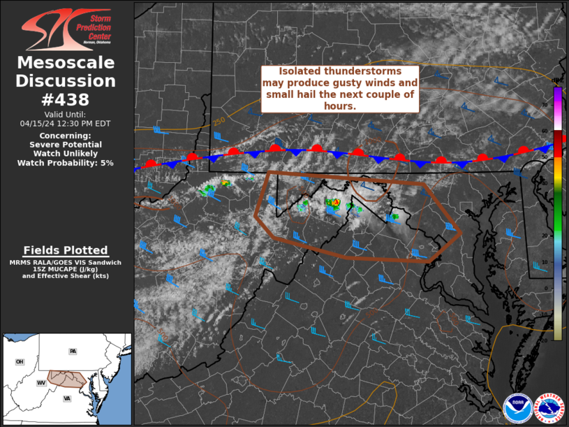
Mesoscale Discussion 0438
   NWS Storm Prediction Center Norman OK
   1001 AM CDT Mon Apr 15 2024

   Areas affected...portions of eastern West Virginia...northern
   Virginia and western Maryland

   Concerning...Severe potential...Watch unlikely

   Valid 151501Z - 151630Z

   Probability of Watch Issuance...5 percent

   SUMMARY...Isolated showers and thunderstorms may produce gusty winds
   or small hail the next couple of hours across parts of the West
   Virginia, Maryland and Virginia border vicinity.

   DISCUSSION...A couple of thunderstorms have developed late this
   morning ahead of a stationary boundary near the WV/MD/VA border.
   This activity is likely somewhat elevated. Nevertheless, weak
   instability (generally less than 500 J/kg MUCAPE) amid steep
   midlevel lapse rates and modest effective shear could support
   sporadic small hail. A dry, mixed boundary-layer and light low-level
   flow also may foster gusty winds around 40-50 mph. This initial
   thunderstorm activity is expected to remain isolated and the overall
   severe threat limited over the next couple of hours, and a watch is
   not expected. The severe threat will increase across portions of
   Mid-Atlantic later this afternoon, and this later threat will be
   addressed with additional MCDs in the coming hours.

   ..Leitman/Smith.. 04/15/2024

   ...Please see www.spc.noaa.gov for graphic product...

   ATTN...WFO...LWX...PBZ...RLX...
-
Area Forecast Discussion...UPDATED
National Weather Service Baltimore MD/Washington DC
910 AM EDT Mon Apr 15 2024

.SYNOPSIS...
A cold front will drop southward through the area tonight,
before returning northward as a warm front on Wednesday. A
strong cold front will move through this weekend, with high
pressure building in early next week.

&&

.NEAR TERM /THROUGH TONIGHT/...

Model trends past 24 hrs have shown storms this afternoon
developing further north than anticipated yesterday roughly now
from along and south of the US-50 corridor or south of I-70
along a lee-side trof. New 13Z SPC DY1 Otlk has shifted the
Slight risk further north into areas south of the Capital
Beltway. Hail is expected to be the primary threat given 7.3
C/km mid-level lapse rates and decent CAPE above -20C seen on
the 12Z IAD sounding. Storms would also be relatively fast
movers with 0-6 km mean winds of 28kt posing a marginal damaging
wind threat.
-
1
-
-
SLGT risk pushed north to DC metro... MRGL to near Mason-Dixon line on 1300z SPC OTLK
-
Hmmm... later today surprise?
NEAR TERM /THROUGH TONIGHT/...
Showers and a few thunderstorms continue to slowly drift
southeastward across the northern half of the forecast area
early this morning. This remnant activity should continue to
weaken over the coming hours, and eventually dissipate prior to
daybreak. Clouds associated with this activity may linger for
the first half of the morning, but clearing and ample sunshine
is expected during the second half of the morning into the early
afternoon.

A diffuse cold front will continue to slowly drift southward
across the forecast area today. Daytime heating will allow
instability to build, with around 1000 J/kg of CAPE present by
peak heating this afternoon. Additional thunderstorms are
expected to develop within the zone of low-level convergence
near the surface front later this afternoon. There`s some
uncertainty as to where exactly this will occur. Any location in
the forecast area has at least a slight chance for a
thunderstorm, but the greatest chance should generally be south
of I-66/US-50 and east of US-15. Further west, westerly flow
and downsloping will act to further dry out an already dry
boundary layer, which should limit storm coverage as a result.
Further north, they`ll likely end up to the north of the best-
low-level convergence, which should also limit the coverage of
storms. Where storms do form, they`ll likely be strong to
severe. Model soundings show an environment that is more typical
of the High Plains than the Mid-Atlantic. Boundary layer
moisture will be rather limited, with dewpoints only in the 50s,
but lapse rates will be very steep (dry adiabatic in the lowest
three kilometers, with mid- level lapse rates around 7.5-8
C/km). Flow will be relatively weak in the boundary layer, but
pick up rapidly in the mid- levels, with continued shear through
the upper levels. Hodographs are relatively straight, so storm
splits may be possible, with both multicells and right/left
moving supercells. Model soundings check a lot of boxes in
recent research for hail producing storms. That may be the
primary threat this afternoon, although the steep lapse rates
and DCAPE values around 1000 J/kg should make damaging winds a
threat as well. Tornadoes aren`t expected with a dry boundary
layer and little to no low- level shear in place. The I-95
corridor south of DC to southern Maryland should stand the
greatest chance of seeing a severe stoms. These storms will
progress off to the south and east this evening, leading to dry
conditions overnight.
-
2
-
 1
1
-
-
New Day 1 has SLGT risk in W MD eastward till around HGR, also includes parts of the Panhandle of WV that borders Maryland
-
Could be interesting if any storm can get into our area tomorrow evening
.SHORT TERM /SUNDAY THROUGH MONDAY NIGHT/...
Flow aloft will become more zonal in nature tomorrow, with a
broad belt of west-southwesterly flow extending from the Upper
Midwest toward the East Coast. A shortwave disturbance will
descend down in the west-northwesterly flow from the Great Lakes
toward Upstate NY. A weak area of low pressure will accompany
the shortwave, along with an attendant cold front which will
drop southward out of NY into northern PA Sunday afternoon.
Locally, it will be a warm day to the south of the boundary,
with temperatures climbing into the upper 70s to near 80 beneath
partly cloudy skies. Thunderstorms are expected to form near the
aforementioned frontal boundary up in PA Sunday afternoon. Much
of this activity is expected to remain to our north during the
daylight hours.

As we move into the evening and the first half of the
overnight, these storms are expected to drift southward along
with the frontal boundary, eventually reaching northern portions
of the forecast area. With loss of daytime heating, the trend
should be for these storms to gradually weaken as they move in
from the north, but a few stronger storms can`t be ruled out.
The environment will be an uncommon one for this part of the
country, with steep lapse rates of 7-8.5 C/km in place as an
elevated mixed layer moves in aloft. If storms do persist as
they track into the area, some instances of large hail may be
possible. SPC currently has portions of northern Maryland and
the West Virginia Panhandle outlooked in a Marginal Risk for
severe thunderstorms.
-
3
-
-
Yay wind
URGENT - WEATHER MESSAGE
National Weather Service Baltimore MD/Washington DC
1022 PM EDT Fri Apr 12 2024

DCZ001-MDZ005-006-011-013-014-503>508-VAZ053-054-506-526-131030-
/O.EXB.KLWX.WI.Y.0015.240413T0400Z-240413T2200Z/
District of Columbia-Carroll-Northern Baltimore-
Southern Baltimore-Prince Georges-Anne Arundel-
Northwest Montgomery-Central and Southeast Montgomery-
Northwest Howard-Central and Southeast Howard-Northwest Harford-
Southeast Harford-Fairfax-Arlington/Falls Church/Alexandria-
Eastern Loudoun-Northwest Prince William-
Including the cities of Washington, Eldersburg, Westminster,
Reisterstown, Cockeysville, Baltimore, Bowie,
Suitland-Silver Hill, Clinton, College Park, Greenbelt, Laurel,
Camp Springs, Glen Burnie, Annapolis, Severn, South Gate,
Severna Park, Arnold, Odenton, Germantown, Damascus, Bethesda,
Rockville, Gaithersburg, Silver Spring, Lisbon, Columbia,
Ellicott City, Jarrettsville, Aberdeen, Reston, Herndon,
Annandale, Centreville, Chantilly, McLean, Franconia, Arlington,
Alexandria, Falls Church, Leesburg, Ashburn, Sterling,
and Haymarket
1022 PM EDT Fri Apr 12 2024

...WIND ADVISORY IN EFFECT UNTIL 6 PM EDT SATURDAY...

* WHAT...West winds 15 to 25 mph with gusts around 45 mph
  overnight, increasing to 20 to 30 mph with gusts around 50 mph
  Saturday.

* WHERE...Portions of central, north-central, and northern
  Maryland, The District of Columbia, and northern Virginia.

* WHEN...Until 6 PM EDT Saturday.

* IMPACTS...Gusty winds could blow around unsecured objects. Tree
  limbs could be blown down and a few power outages may result.
-
1630z OTLK disco
   ...Mid-Atlantic States and Carolinas...
   A less focused and less certain severe risk appears to exist across
   the region. Cloud cover remains prevalent at midday coincident with
   low-level upslope flow, although some clearing is noted early this
   afternoon across the southern Appalachians vicinity. Where modest
   destabilization does occur this afternoon, long hodographs would
   conditionally support storm organization with any robust updrafts.
   Isolated to widely scattered strong to severe storms capable of a
   threat for damaging gusts and a couple of tornadoes are possible,
   particularly near the mountains/Blue Ridge, with a lower
   probability/lesser anticipated storm coverage expected farther east
   over the coastal plain/Delmarva.
-
30 wind added in SW PA/W WV on 1630z OTLK
-
Area Forecast Discussion
National Weather Service Baltimore MD/Washington DC
1019 AM EDT Thu Apr 11 2024

.SYNOPSIS...
Low pressure will track into the Great Lakes today, with an
associated cold front moving through tonight. Upper troughing
will linger overhead tomorrow, with a reinforcing cold front
moving through tomorrow evening. High pressure will build to our
south this weekend. A weak area of low pressure will track to
our north late Sunday night into early Monday, before high
pressure regains control early next week.

&&

.NEAR TERM /THROUGH TONIGHT/...
1030 AM Update: Showers are starting to approach the area late
this morning with some partial clearing happening across
western portions of MD and the eastern WV panhandle.
Temperatures are already climbing into the mid to upper 60s
across the lower elevations. It is worth noting a dry slot
building in behind the initial cold front passage affecting
areas further south of our CWA. Discrete cells and clouds should
begin building back in through the early afternoon with
increasing rain chances.
-
Both 12z NAM and NAM NEST have some decent curved and looping hodographs around 06z in the region with 300 m2/s2 with 500 to 1000 SBCAPE
-
1300z SPC OTLK update
Mid-Atlantic states into Carolinas...
   A less focused and more conditional severe risk seems evident for
   the Carolinas later this afternoon and northward into the
   Mid-Atlantic states this evening as the upper trough encroaches on
   the general region.  A broad warm-air advection regime north of the
   FL/GA early-day MCS will slowly destabilize today, aided in part by
   lower 60 deg F dewpoints north, mid to upper 60s south.  Long
   hodographs will favor storm organization with any robust updrafts.
   Isolated to widely scattered strong to severe storms capable of a
   threat for damaging gusts and a couple of tornadoes are possible,
   mainly over parts of western VA, with lower coverage expected
   farther east over the coastal plain/Delmarva.
-
Morning AFD from LWX on the threat
The upper trough will take on a negative tilt as it moves
overhead tonight. At the surface, low pressure will deepen as it
tracks into the Ohio Valley. Thunderstorms are expected to form
within the zone of strong forcing for ascent ahead of the
negatively tilted trough across OH/WV/SW VA late this afternoon
into early this evening. These storms should initially reach
far southwestern portions of the forecast area during the late
evening, before progressing northeastward across the remainder
of the forecast area between 10 PM and 4 AM.

Instability will increase through the evening as a low level
mass response occurs ahead of the approaching trough. CAPE
values are expected to increase to around 300-600 J/kg across
much of the area. When coupled with an impressive low- level jet
and ample deep layer shear present, some of the storms this
evening into the overnight may be on the strong to severe side.
Damaging winds should be the primary threat, but a brief tornado
can`t be ruled out given the strong low-level jet, 0-1 km SRH
values increasing to around 200-300 m2/s2, and STP values
climbing above 1. Weak stabilization evident on forecast
soundings right near the surface may potentially serve as a
limiting factor for both the damaging wind and tornado
potential. SPC currently has locations to the west of the Blue
Ridge outlooked in a Slight Risk for severe thunderstorms, while
locations to the east of the Blue Ridge are in a Marginal Risk.
-
2
-
-
Day 1 Convective Outlook
   NWS Storm Prediction Center Norman OK
   1247 AM CDT Thu Apr 11 2024

   Valid 111200Z - 121200Z

   ...THERE IS AN ENHANCED RISK OF SEVERE THUNDERSTORMS ACROSS PARTS OF
   THE UPPER OHIO RIVER VALLEY...

   ...THERE IS A SLIGHT RISK OF SEVERE THUNDERSTORMS ACROSS PORTIONS OF
   THE OHIO RIVER VALLEY AND NORTHERN FLORIDA TO SOUTHERN GEORGIA...

   ...SUMMARY...
   Severe thunderstorms with a few tornadoes, scattered damaging winds,
   and isolated large hail are possible across the upper Ohio River
   Valley and parts of the Appalachians this afternoon. Scattered
   damaging winds and a couple tornadoes will also be possible across
   southeast Georgia into northern Florida, mainly this morning through
   early afternoon.

   ...Synopsis...
   04 UTC surface observations depict a diffuse surface low over the
   lower MS River Valley. This low is forecast to deepen over the next
   24 hours as it lifts northward into the OH Valley/Great Lakes region
   in tandem with the phasing of an amplified upper-level trough over
   the MS Valley with an approaching upstream perturbation. A surface
   cold front currently draped across southeast LA will surge to the
   east/northeast as the low deepens, and should act to focus
   thunderstorm development through the late morning and afternoon
   hours across both the upper OH Valley and Southeast.

   ...Upper OH River Valley...
   Recent 925/850 mb analyses and surface observations show a
   consolidating warm frontal zone draped from the surface low over the
   lower MS Valley into the upper OH River Valley. The surface low will
   deepen along this corridor amid a combination of strong height falls
   and ascent within the left-exit region of a mid-level jet. A plume
   of low to mid-60s dewpoints will advect northward with the deepening
   low, establishing a focused warm sector ahead of the approaching
   cold front by early afternoon across parts of KY, OH, and WV. The
   current expectation is for sufficient destabilization within the
   warm sector to support surface-based convection by the 18-21 UTC
   time frame. A combination of strong synoptic-scale ascent and 40-50
   knot deep-layer shear vectors off the cold front should promote a
   mix of discrete cells and semi-discrete clusters - including the
   potential for a few supercells. Increasing southeasterly winds
   through the lowest 1-2 km should yield effective SRH values between
   150-300 m2/s2, which will support a tornado threat with the more
   robust/organized cells as well as a wind threat with more organized
   clusters. This threat appears greatest across southeast OH into
   western WV where latest guidance continues to show a focused
   convective signal. Further to the east into parts of northwest VA, a
   somewhat weaker convective signal is noted in most CAM guidance, but
   50-knot flow in the lowest 2 km will likely pose a substantial wind
   threat with any storms that can mature. Risk probabilities have been
   expanded into this region to account for this potential.

   That said, this scenario appears to be conditional on achieving
   sufficient low-level warming within the warm sector. While an
   extensive dry slot is noted in water-vapor imagery across the
   Mid-South into central IN, the low/mid-level warm advection regime
   is maintaining mid-level stratus across the region with most ASOS
   stations reporting overcast skies and ceilings near 6 kft. It is
   unclear how much clearing will occur through early afternoon given
   persistent ascent, and a 10 F spread in afternoon high temperatures
   is noted across OH/WV in recent ensemble guidance. Based on forecast
   soundings, surface temperatures in the upper 60s may be required to
   realize 500+ J/kg SBCAPE with minimal inhibition. The median of the
   temperature distribution appears to reside in the upper 60s, but
   SBCAPE may still only reach 500-1000 J/kg per ensemble
   distributions.
-
SLGT risk moved into most of N VA and C MD on new Day 1 for 15 wind and 5 tornado
-
1
-
-
1 minute ago, buckeye said:
here we go again


-
Still MRGL on 1730z SPC OTLK... but a small ENH risk was added in E Ohio into West Virginia with 10% tor probs added
-
Might get a slight risk upgrade at 1730z
-
Updated morning AFD from LWX now mentions tornado threat
SHORT TERM /THURSDAY THROUGH FRIDAY NIGHT/...
Rain chances increase further Thursday morning as a frontal
system inches closer to the region, but the bulk of
precipitation likely arrives Thursday afternoon. Strong
southerly winds are expected to develop ahead of the approaching
cold front, which could reach 25 to 35 mph or so.

The upper trough that is currently digging into the MS River
Valley will lift northeastward towards the Great Lakes, becoming
negatively-tilted into Thursday evening/night. Given the amount
of pre-frontal showers and clouds, instability looks to be hard
to come by, especially with the timing looking to be later in
the evening into Thursday night. However, given height falls
aloft and anomalous low-level moisture, 200-400 J/kg ML/SBCAPE
still looks achievable. This, combined with increasing low-level
flow to 50+ kts at a few thousand feet AGL (especially late at
night Thursday into early Friday morning) could be enough for
low-topped convection capable of bringing down damaging wind
gusts or spinning up a brief tornado or two. The greatest
potential for any severe weather appears to be Thursday night.
-
3
-
-
   SPC AC 100551

   Day 2 Convective Outlook
   NWS Storm Prediction Center Norman OK
   1251 AM CDT Wed Apr 10 2024

   Valid 111200Z - 121200Z

   ...THERE IS A SLIGHT RISK OF SEVERE THUNDERSTORMS IN THE UPPER OH
   VALLEY AND PARTS OF THE SOUTHEAST...

   ...SUMMARY...
   Severe thunderstorms with a few tornadoes, scattered damaging winds,
   and isolated large hail are likely across the Upper Ohio Valley
   vicinity, mainly during Thursday afternoon. Scattered damaging winds
   and a few tornadoes will also be possible across southeast Georgia
   into central Florida, from Thursday morning into the afternoon.

   ...Synopsis...
   A full-latitude mid/upper trough will be centered near the MS
   Valley at 12Z Thursday, comprised of two primary shortwave impulses.
   The southern-stream impulse should pivot northeast and accelerate as
   the northern-stream impulse becomes the dominant embedded feature. A
   steadily deepening surface cyclone will track northeast from the
   Lower OH Valley to the Lake Huron vicinity during the period.

   ...Upper OH Valley...
   A synoptically favorable corridor for a few supercells and organized
   clustering into short-line segments appears likely to develop east
   of the gradually deepening surface cyclone track. This region should
   have a period where an overspreading mid-level dry slot coincides
   with the diurnal heating cycle, before afternoon convection develops
   within the left-exit region of the strong mid-level jet across the
   Southeast and southern Appalachians. MLCAPE should reach 500-1000
   J/kg amid a meridional supercell wind profile, before low-level flow
   becomes veered from the southwest. Consensus of 00Z CAM guidance
   supports the potential for a few supercells, with some upscale
   growth into a line segment as convection consolidates northeastward.
   This may be relatively short-lived as convection outpaces the weak
   buoyancy plume and likely weakens after dusk. A mesoscale corridor
   of greater severe probabilities, seemingly in the form of damaging
   wind, may be warranted in later outlooks.

   ...Southeast GA to central FL...
   Extensive deep convection should be ongoing from north FL into GA at
   12Z Thursday. The southern portion of this activity will have the
   best chance to maintain a damaging wind and embedded tornado threat
   during the late morning into about mid-afternoon as stronger
   boundary-layer heating occurs across the FL Peninsula. Large-scale
   ascent will subside with southern extent through the day given the
   northeastward track of the surface cyclone, in addition to low-level
   winds becoming more veered in time over the FL Peninsula.

   ...Carolinas and VA...
   Overall severe threat appears rather conditional during the daytime
   hours given extensive convection across at least north FL and GA on
   Thursday morning. Diabatic surface heating should be quite limited
   by abundant downstream cloudiness/weak convection north of the
   deeper convection during the day. Consensus of guidance largely
   attempts to destabilize on the backside of early-day convection
   within a plume of at least mid 60s surface dew points. Overall
   threat will probably consist of sporadic damaging winds and up to a
   few brief tornadoes within lower-topped convection, mainly from
   midday through Thursday evening. With the expectation for lesser
   severe weather coverage relative to areas farther northwest and
   south, have opted to highlight much of this region with a cat 1-MRGL
   this cycle.

   ..Grams.. 04/10/2024
2024 Severe Weather General Discussion
in Mid Atlantic
Posted
Severe Thunderstorm Watch coming soon per SPC MCD