

wncsnow
-
Posts
8,829 -
Joined
-
Last visited
Content Type
Profiles
Blogs
Forums
American Weather
Media Demo
Store
Gallery
Everything posted by wncsnow
-
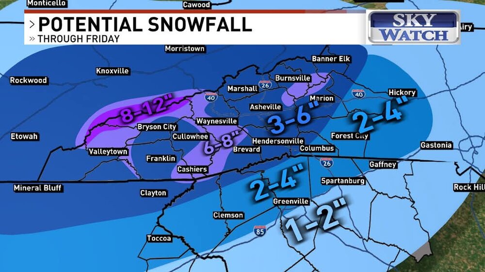
 Foothills Weather network increased from 1-3 to 3-6 for most of I 40 north in WNC. If I can find their map I will share
 -
Local Mets increasing totals now
-
Good trends fellas! I think Boone might be the big winner if they hey enough of the heavy rates
-
NAM and hires definitely trended colder. It was also very juiced up!
.thumb.png.0278ce5eab7ef2bbf6493af3db2fc1a9.png)
-
New NAM switches from snow to sleet back to snow for WNC mountains and northern foothills
-
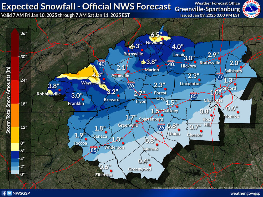
NAM snow totals are still super ugly. I wonder what NWS will say
-
NAM slightly colder again but still more.amped than others
-
The thermals were mostly ok for us. Little bit less precipitation but still a solid look.
.thumb.png.2569ffb0ef75b43ad54ef4f2c59b797d.png)
-
Snow totals will be lower in WNC this run. Less moisture and warm nose more pronounced.
-
HRRR is coming in warmer mid levels with the sleet line about 50 miles north of 18Z so far
-
1/10-11 super awesome winter SE OBS thread
wncsnow replied to strongwxnc's topic in Southeastern States
I worked for Danville Parks and Rec for about 4 years. I might know you!. -
1/10-11 super awesome winter SE OBS thread
wncsnow replied to strongwxnc's topic in Southeastern States
Which department do you work for? -
Interestingly enough some of the globals decreased qpf again
-
Anyone got the 18Z euro?
-
These things are normally true- 1. The initial front end thump of snow is stronger than modeled and puts down at least an inch or 2 more than forecasted. 2. The warm nose sets up somewhere within 30 miles of I 85. 3. Heavier precip could mean sleet and snow while lighter returns yield freezing rain. 4. The snow starts a few hours before and ends a couple hours before models show it.
-
Gotta hope the NAM is way wrong
-
Boyer upped totals
-
NWS leans heavily on the NAM. If the 00Z NAM trends less amped, I bet they adjust again.
-
Looks solid gents
-
The SREF increased totals from the previous run. I expect the next NAM to be snowier.
-
increase in the snow mean too!
.thumb.png.76d8a36c61a01e2eb5b7e120f962ff45.png)
-
I'll take it

-
NWS loves the NAM.
-
Haven't updated since issuing the WSW
-
It's still on an island but it moved towards the other solutions

.png.39b7a8c5a10bf6f6acbf2cb1a5dd8f5e.png)
.png.5cb51e95ec7944f169ff08087c31efb6.png)


.png.82ae88b1fc37e2175c7edf70d2add597.png)
