

wncsnow
-
Posts
5,733 -
Joined
-
Last visited
Content Type
Profiles
Blogs
Forums
American Weather
Media Demo
Store
Gallery
Posts posted by wncsnow
-
-
5 minutes ago, GaWx said:
Far different from 0Z ICON. Cold press to the NE significantly weaker vs 0Z and further N track of storm.
Seems to be the theme all winter.
-
 1
1
-
-
-
Just now, GaWx said:
The Weeklies clearly moderated over the weekend vs those with a stronger cold signal late last week.
I'm still trying to hold out an ounce of hope for mid February but it's getting harder to be excited with all these teases from the ENS and now weeklies. A good pattern is always on the other side but you can never reach it..
-
 1
1
-
-
20 minutes ago, GaWx said:
Here's the 0Z ICON clown, which I'd obviously love to verify with its 3" of snow imby (would be biggest snow since Dec of 1989) but am not at all buying now considering how much warmer are the GFS/Euro suites, the general inferiority of this model vs those, how much colder this run is vs yesterday's 12Z ICON, it still being out a week, and the extreme rarity of snows like this here:

Are the weeklies still showing a good pattern or have they moderated too?
-
It's chilly but not cold. You can feel a touch of spring in the air. No snow in Asheville, too warm. Wild in late January that you get a good NWFS and it's rain or mix except 3k and up.
-
1 hour ago, GaWx said:
The idea of there being much less cold air to the north in advance of any storm on the 0Z GFS suite was also on the 0Z Euro suite vs its 12Z run as well as on the 6Z GFS suite. Not a good trend on these last two GFS suites or the 0Z Euro suite for SE wintry prospects as they’re too warm. They’re going to need to reverse course or else that would be all she wrote for SE wintry prospects from this system.
The trough is too far northeast. The lack of cold air is alarming much like December again. It's going to take time to cool North America back down. We were punting until Mid Feb anyways right?
-
 1
1
-
-
2 minutes ago, Met1985 said:
I think honestly the snow doesn't start until dark anyways which will be much better for accumulation.
I drove over to Johnson City today up through Red Hill and Buladean in Mitchell county. You could tell where the heavy snow has fallen with the trees that have fell.
-
2
-
-
1 minute ago, Met1985 said:
Lol now you know the 3k NAM is crap at upslope snow. The 12k and gfs do look good.
It is but generally the models have cut totals for Buncombe. It's going to be too warm tomorrow for it to stick in the lower elevations like Asheville. Whatever falls after dark will have a better shot at accumulating there. TN border will do great as usual. I'm just trying to see some snow at work Monday
-
Wacky pattern coming up. Rare to see ridging this strong in Canada in the winter. Hopefully we all score at some point.
-
3
-
-
8 hours ago, westmc9th said:
Where's @wncsnow. I need someone to help tamper expectations

Here watching the short range cut totals for Asheville.
.thumb.png.4de64b64824eeb415e68a513713b7474.png)
-
Look at this.. even if it doesn't snow in the next few weeks this weird pattern is going to be something to behold
.thumb.png.1f7c8e51351200186650110daeffa4b0.png)
-
2
-
-
Not warm but definitely not cold
.thumb.png.db742fdaaea86fe9eace606afbce8513.png)
-
4
-
-
Northern Mtns are going to rack up again
.thumb.png.02e24478ee551cefa8b9886eefd2396c.png)
-
2
-
-
All snarkiness aside, I think the pattern late next week is really fascinating albeit unlikely to produce snow for most (other than a little NWFS of course). Some nice North Atlantic blocking showing up causing a stagnant flow. So strange to see a map like this...
.thumb.png.2a6a495ac96f54b71f7ab298d8b63a4c.png)
-
1
-
-
Really anomalous pattern coming up. Not often is the 540 line in Northern Canada and WNC at the same time..
.thumb.png.9787e61059d1e1dcc7e73aa9c62b418d.png)
-
1
-
-
Haven't seen the sun in 3 days, haven't seen snow IMBY in 2 years. Sarcasm is in short supply
-
 2
2
-
 1
1
-
-
3 hours ago, westmc9th said:
At least we have a fantasy storm(s). We haven't had too many of those lately.
Now we don't
.thumb.png.99b6ba62a3bd02bdb797ca23d865f61e.png)
-
5 hours ago, Met1985 said:
I have to disagree on that. This winter has been nothing like the last few. Last winter we had what 2 cold spells? One minor snow. Yes snow wise things have been lacking but it's still only January 24th. Temp wise we have done much better. We've seen several weeks and days with below normal temps or near normal temps. Sure We've seen the 33 and rain but we are really close to scoring region wide.
This warm.up has been advertised since last month. The weeklies had flipped to a warm January for a few runs then came back down to reality. Sure the weeklies have flipped here a d there but they have been the most stable out of the long range models to date.
The eps has also done a great job noting the current pattern. It you watch run to run op solutions you are going to go crazy. Just the fact of things.
And now the mjo is showing signs of moving through the warm phases quicker so the actual cool down coming back is moving up at this hour. No can kicking that I can see. No pushing this pattern back at all at this stage.
Your looking at a strictly IMBY viewpoint. Last winter we had a similar cold stretch in December to the one we just had. We also had a decent NWFS in January which you just had this month. We also had no snow or even legitimate snow threats within 5 days for the foothills and piedmont last winter and that's been the case this winter too. It's been wetter overall since late December than last winter which has helped keep the temps down.
Yes it has been a little colder overall but its not like this winter has been a complete 180 from last. The temperature departures in January are going to look like a La Nina, not an El Niño (cold upper Midwest). The system that brought TN valley snow was more like a La Nina system not El Nino. Most of the mountains and ski areas are still pretty far below their 30 year average for snow but obviously doing better than just east.
-
38 minutes ago, GaWx said:
1. The Euro Weeklies (EW) from late Dec were overall WAY off for mid Jan to early Feb but it wasn’t just in the too cold direction.
2. The week of Jan 15-22 ended up WAY too warm on the EW in late Dec, less than 3 weeks out. It later corrected and ended up ~6 BN at RDU, very accurate:
3. Here’s the map I was referring to (in the post you quoted) with a strong signal for cold in the final week of the 12/31/23 EW (for Feb 5-12), which as of now is likely to bust way too cold:

4. The EW from many late Dec/very early Jan runs for Jan 22-29 will end up busting WAY too cold as many runs had NN well inland to BN nearer to the SE coast. However, as Jan 15-22 corrected much colder, Jan 22-29 soon after started correcting much warmer and has since been warm for many runs. It is almost as if once the Ninalike (coldest Plains/MW) extreme cold of Jan 15-22 was seen, the outlook to much warmer following it started to also be seen soon afterward.
5. The week of Jan 29-Feb 5, which was also NN well inland to BN nearer to coast on runs in late Dec/very early Jan is still in some doubt as a good number of recent GFS runs have been no warmer than NN in much of the SE, largely helped by cold CAD. You even said this just 2 days ago:
“Well the idea of 3 weeks of solid warmth is getting derailed at least in the ops. Canadian actually first to pick up on the cooler first week of Feb (it’s backed off somewhat). GFS has trended way colder.”
6. The Weeklies from late Dec/early Jan weren’t quite screaming BN the whole period in the entire SE, but rather mainly NN well inland to BN nearer to coast other than all solidly BN Feb 5-12. Still way off though (much too cold Jan 22-29 and probably Feb 5-12 and much too warm Jan 15-22 with Jan 29-Feb 5 still in doubt).
7. I never trust models in week 2, much less extended models. I just use them as guidance in combo with climo, analogs, etc.
8. The main purpose of this thread is supposed to be to discuss what each of us sees down the road as possibilities, whatever they may be. We’ll always have different takes, which makes for good discussion as long as it doesn’t deteriorate into too much confrontation/negativity toward each other. The posts made out of frustration have a better place, the Sanitarium thread. The most enjoyable part for me is to try to sniff out pattern changes well in advance by using history/climo as a guide.
9. Most of NC missing SN mid Jan has little bearing on their chances of getting it mid Feb to early Mar imho, especially in a moderate+ Nino.
Thanks for verifying this. All I have been trying to say is the weeklies should be taken with a grain of salt. They are slightly better than searching for a black wooly worm.
-
2
-
1
-
-
On 1/15/2024 at 1:47 PM, Leesville Wx Hawk said:
Need ridging in the west via Aleutian low (+PNA) so that cold air from Canada can move SE into our region. This should happen in about 2 weeks hopefully.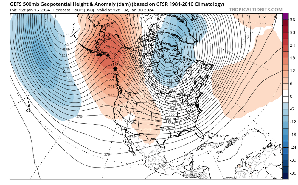
12 Z GEFS ensemble shows a ridge in the west that pushes the SE ridge. While not perfect, this is a better synoptic pattern for our region and something to follow moving forward.This was 9 days ago and looks nothing like the upcoming pattern.
-
15 minutes ago, BooneWX said:
It’s always this progression:
cold—-brief warm up—-rain——cold——brief warm up
on the bright side, the pattern is reloading. Is this our shot? Idk. If we get to Feb 25th with nothing, I’ll be ready to punt our way into spring. I’m still optimistic for now though - it’s probably the best pattern in a while for our region since the cold doesn’t look displaced too far west.
You know deep down what will happen. A few cold days then warm up and rain.
-
2 minutes ago, Met1985 said:
For the most part we have been at average or below. We just haven't had a synoptic storm line up. But our friends to the west sure did make out nice. This warm up has been well advertised for over a month. This is not a surprise and people who act like this is a surprise do not follow this hobby well.
It was modeled about 7 to 10 days ago. Before that, the weeklies and long range ENS continued to say cold or average and stormy. Now the Pac Jet has taken over again. The fact is, this winter has been much like the last few. Temperatures have been slightly cooler but no synoptic storms, miller A's, ULL, etc.
-
1 hour ago, Met1985 said:
Euro Weeklies and the eps, and the GEFS all look good for a return to a more stable winter pattern around the 8th of February. The Weeklies look really good from the 2nd week of February all the way to the first of March. We are looking at the bigger picture here not individual storms at this point.
The weeklies also showed the whole month of January being great into February at one point. We all see how that turned out. One week of cold temperatures and some snow in the mountains
-
1
-
 1
1
-
-
59 minutes ago, Met1985 said:
Euro Weeklies and the eps, and the GEFS all look good for a return to a more stable winter pattern around the 8th of February. The Weeklies look really good from the 2nd week of February all the way to the first of March. We are looking at the bigger picture here not individual storms at this point.
The big picture says wait at least 3 weeks
-
1
-
.png.050f3c095dcf02e5fc7afecbb190c3d4.png)
.png.5bb31d9df5c0ea0293f7a9387104d220.png)
.png.0ed0d6423aaf94f60f325c183c76cdc1.png)
.png.cccec2180c15cc7ef5a9770006fd55be.png)
.png.0bdc8b3c4ae27dc170e37514bdd0f4ef.png)
.png.d4eae8cd2f8e5d1bc831ba281bc496a3.png)
.png.161cda36d80514648431f53ec85b68b8.png)
.png.c33a68f7fa64b47886c2d4019b661b73.png)

Mid to Long Range Discussion ~ 2024
in Southeastern States
Posted
GFS is even warmer this run for the 4th-5th for piedmont areas