

wncsnow
-
Posts
5,723 -
Joined
-
Last visited
Content Type
Profiles
Blogs
Forums
American Weather
Media Demo
Store
Gallery
Posts posted by wncsnow
-
-
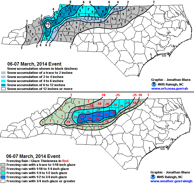
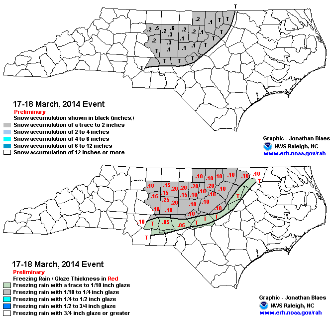
Going back to the question of can their be an ice storm late in the season, here are a few more examples since 1970 in NC
-
 2
2
-
 2
2
-
-
I'm going to give it 3 more weeks before I'm totally done
-
GFS looks like it might be warmer and amped this run
-
45 minutes ago, StantonParkHoya said:
How common is ZR this late in the season?
I have seen ice storms in March here. Not sure about Triangle but it's not THAT late in the season
-
29 minutes ago, GaWx said:
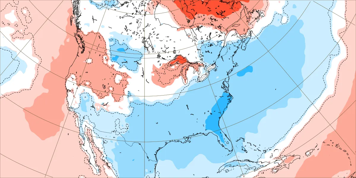
This is the coldest the Euro Weeklies have been in the SE for the week of 2/19-26: dark blue is ~6-7 F BN. That’s pretty significant for an ensemble mean and it could even trend colder. But even if not, a week of 6-7 BN implies the coldest day would probably easily be in the teens or so BN.
How do the other weeks look?
-
We were 24, 23 and 27 the last 3 mornings all with highs in the upper 50s to near 60.
-
1
-
-
I'm cautiously optimistic we will score in the next 2 or 3 weeks. Obviously mountains have the best shot but north of 40 folks in the foothills could do well too
-
6
-
-
2 hours ago, Met1985 said:
I would suggest people look at the models verification scores recently also. The OP GFS has been horrible. Just putting that data out there.
The GFS is awful. When you are behind the Canadian it's a real shame. Idk why our supercomputers can't come up with better data/modeling.
-
1
-
-
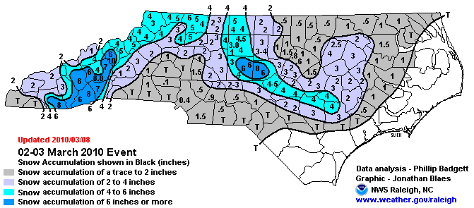
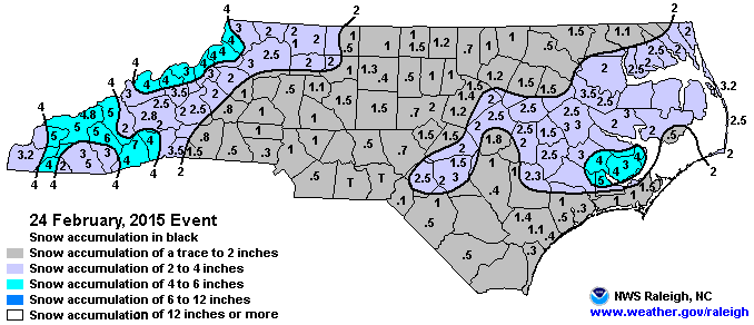
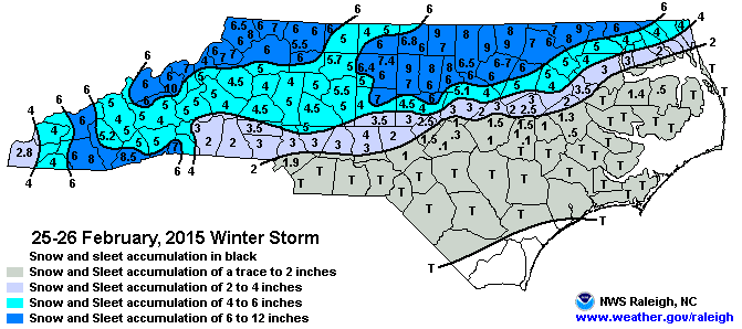
1 minute ago, wncsnow said:
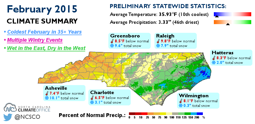
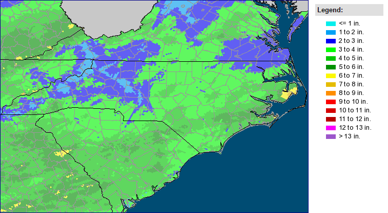
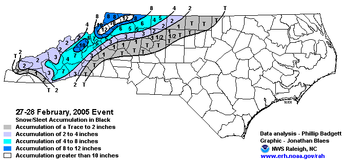
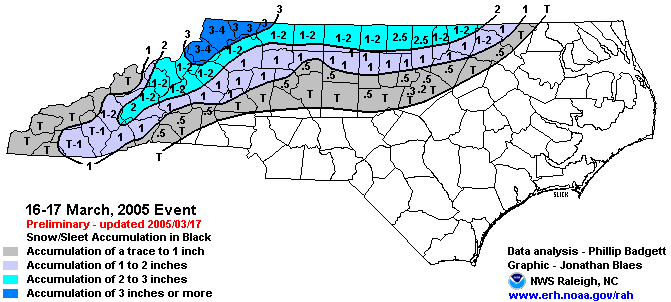
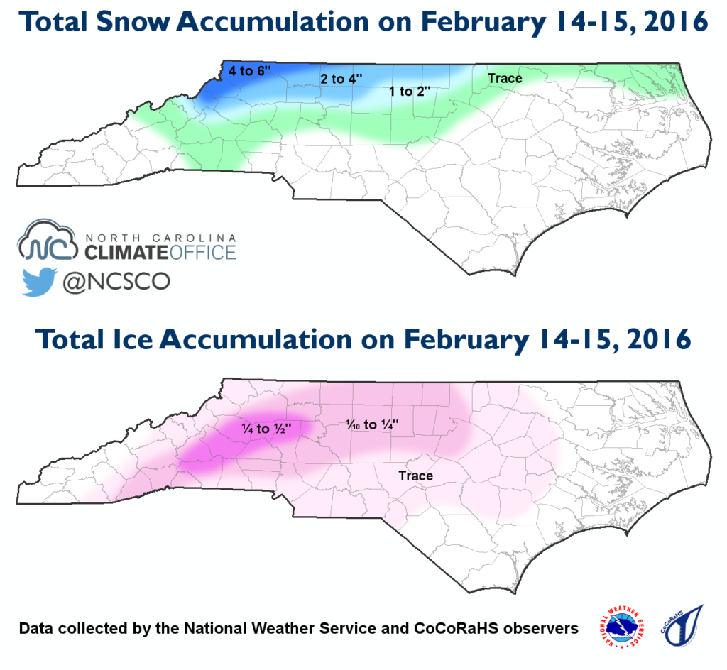
If we can pull out a 2 week stretch like February 2015 I think a lot of us 40 north folks would be happy. That winter was pretty boring until late and was an El Nino.
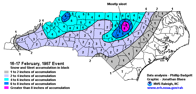
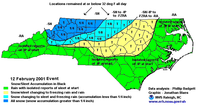
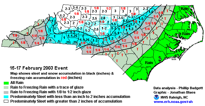
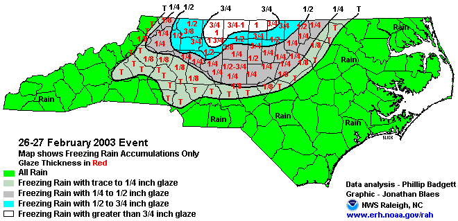
More maps from that period
-
1
-
1
-
-
If we can pull out a 2 week stretch like February 2015 I think a lot of us 40 north folks would be happy. That winter was pretty boring until late and was an El Nino.
-
4
-
-
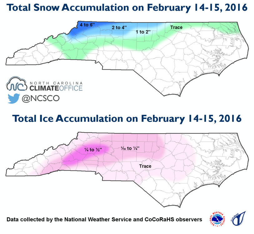
I'm no GaWx but I did some research on late season snowstorms during El Nino's since 2005. There were a few other small events but these are the main ones.
-
3
-
2
-
-
26 minutes ago, GaWx said:
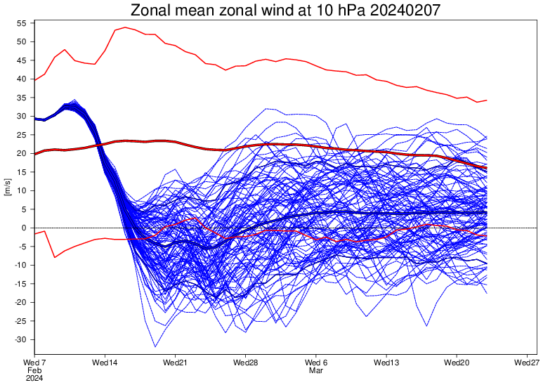
The new (2/7) Euro Weeklies 10 mb stratospheric 60N wind run’s mean hangs around -5 for a week and then never rises back above +5 (through Mar 23)! Most of the wind reversal dates (major SSW) are within Feb 15-17 and the members imply a good chance for a dip to sub -10. This is even more support favoring a cold SE US along with more winter storm opportunities well into March.
-
2
-
1
-
-
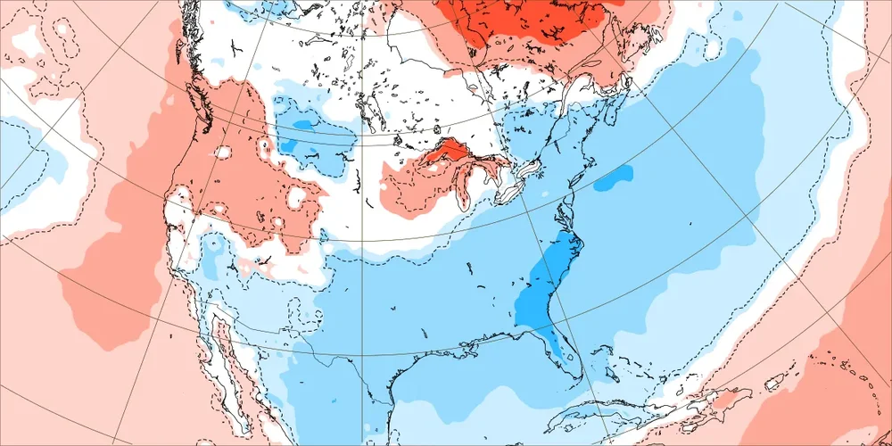
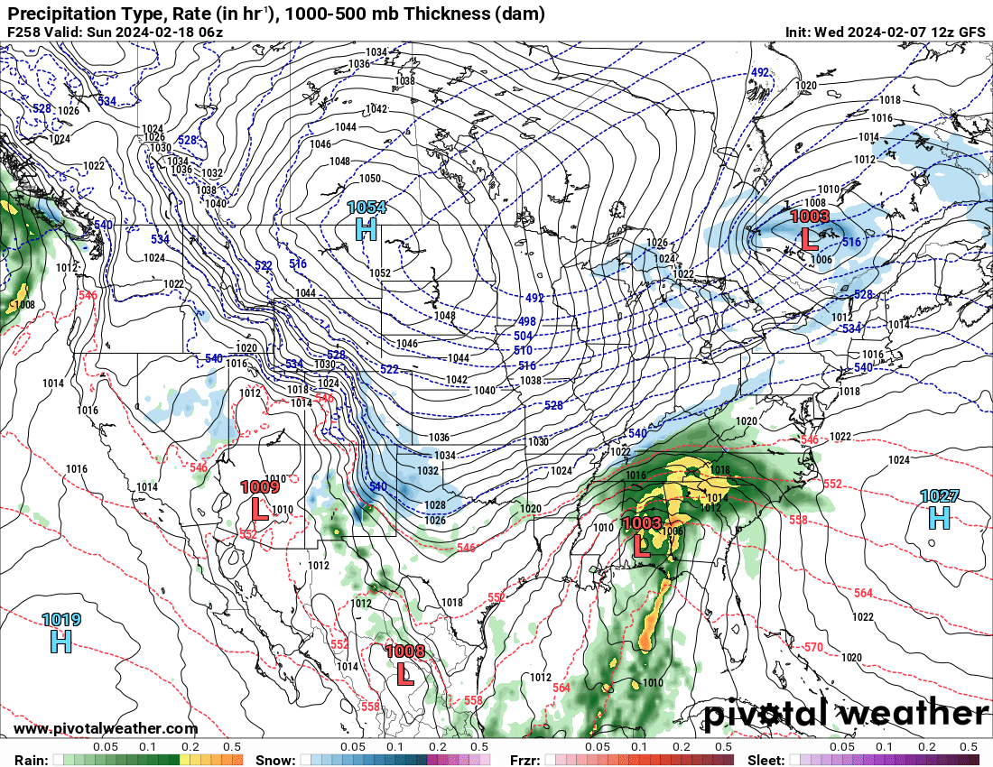
This is a good look at day 10
.thumb.png.f842e0b1b3f7acd6138835b23e885c82.png)
-
2
-
 3
3
-
-
5 minutes ago, Met1985 said:
There's just been a ton of shit posting.
I understand but come on man I thought we were beyond that.
-
 1
1
-
-
4 minutes ago, Met1985 said:
You just did on the 06z! WTF are you smoking?
It's easy to get under your skin
-
 1
1
-
-
9 minutes ago, weatherfide said:
That potential storm is well out in fantasy land. I'm waiting on the GEFS for some ideas, though the last few runs of the GEFS haven't had many members with much snowfall in the southeast. Usually the means have been skewed by one or two big snow outputs.
We can't even win in fantasy land
-
1
-
-
Darn you SE Ridge
.thumb.png.1be0e9c53691b10d46532c8870aec6f9.png)
-
-
39 minutes ago, GaWx said:
The -AO isn’t quite as strong as it was on yesterday’s GEFS, when it averaged -3.5 for 2/13-20. Today the period averages near -3.0. The chance for a sub -4 daily isn’t as high. Hopefully it won’t trend less negative in the coming days. A -3.0 would still make it the 3rd most negative for the period during El Niño. Also, the PNA prog for the period has risen from yesterday’s +0.5 to today’s +0.8.
Strongest -AO El Niño averaged 2/13-20 (lowest daily) out of 25 Ninos since 1952:
1969: -4.8 (-5.1) (PNA: -0.1)
2010: -4.4 (-5.1) (PNA: +0.7)
1978: -2.6 (-4.8) (PNA: +0.8)
1958: -2.5 (-4.0) (PNA: +1.1)
1970: -2.4 (-4.0)
1964: -2.4 (-3.4)
1987: -2.4 (-3.3)
1966: -2.2 (-3.5)
1952: -2.1 (-2.5)
1983: -2.0 (-2.7)
1977: -1.2 (-2.1)
2007: -1.2 (-1.9)
2005: -1.1 (-1.7)
Keep that PNA rising and I'm not as stressed about the AO.
-
1
-
-
Can the negativity get over the top here? Sure. But so can the wishcasting for snow and cold. When many places haven't seen snow in over 2 years its tough to stay positive.
-
2
-
-
I find a forum that doesn't allow differing opinions to be a waste of time. Differing opinions and data points are always the way to go .
-
1
-
-
If I had a dollar every time the Weeklies were wrong I could have a great time at the local strip club
-
1
-
2
-
-
5 hours ago, GaWx said:
The new Euro Weeklies are significantly colder along with more widespread cold vs recent runs for the period Feb 19-Mar 18. There’s now a solid signal for cold for much of the E US thanks to strong blocking at high latitudes as well as moderate blocking along the W coast. This more intense cold lasting well into March is likely being aided by the most bullish run yet for a mid-month major SSW, which on its own increases the chance for a cold E US starting 1-3 weeks later and which often lasts for several weeks after it starts.
Along with this forecasted cold, the Weeklies maintain an El Niño induced subtropical feed of moisture in the GOM and up along the SE coast. All of the SE is NN to wetter than normal. So, the SE may very well get more winter storm opportunities into mid March! This winter appears to be a long way from ending.Don't worry it will change next run, it always does.
-
1
-
1
-
1
-
-
So, when are the Ops going to start showing this great pattern? We are starting to get in better range and its looking like more of the same. Get cool for a few days, warm up, rain, get cool for a few days, warm up, rain.
This is not exactly arctic air day 9. So are we thinking February 20 or later? April?
.thumb.png.b9e4661a48ceef793e9081f098f3a24f.png)
-
1
-
1
-
.png.513836da556422cd16e224f8da988841.png)
.png.e111fcbd8b691ddde7eff001337de29c.png)
.png.2cbe43917b084922f14719bdbe21eb76.png)
Mid to Long Range Discussion ~ 2024
in Southeastern States
Posted
Ends up squashed but I take squashed over amped.