

wncsnow
-
Posts
5,747 -
Joined
-
Last visited
Content Type
Profiles
Blogs
Forums
American Weather
Media Demo
Store
Gallery
Posts posted by wncsnow
-
-
15 minutes ago, wncsnow said:
Don't think this run will take it as far to the SW still spinning on same spot off Jacksonville NC at 78.
Well I was wrong it went even further SW into Georgia..Has to be an all time anomalous track if it happens.
-
 1
1
-
-
Don't think this run will take it as far to the SW still spinning on same spot off Jacksonville NC at 78.
-
I think with all of the big event cancellations ranging from races, festivals, school closings and college football games, people are expecting something major in the piedmont of NC and VA. If current trends hold, a lot of people will be angry and in my opinion it will be a blow to meteorology in general because so many people believe the science behind it is little more than a government conspiracy.. I have already seen respectable mets such as Brad Panovich getting ripped on social media due to the track changes.. and it's going to get worse..
-
 1
1
-
-
This run would be bad for Blue Ridge areas for flooding after it finally decides to come inland. I am growing more concerned for that area with each model run..
-
Just now, downeastnc said:
No way that was horrible for the beaches the thing will have a 20-30 mile wide eye the entire coast from Bogue Banks to ILM would be in extreme conditions and then the surge would push in and stay there since the storm isn't moving so the winds don't change and let the water out.....
Yes it would be horrible BUT not as horrible as other model solutions..
-
1 minute ago, AsheCounty48 said:
On this run, the NC coast still gets obliterated with rain and surge, and since the Storm moves SW, it goes over hot gulf stream waters and re intensifies quickly. Take verbatim, it's an awful run.
It wont intensify much if any due to upwelling and it is still the best run I have seen for NC coasts compared to EURO and other solutions.
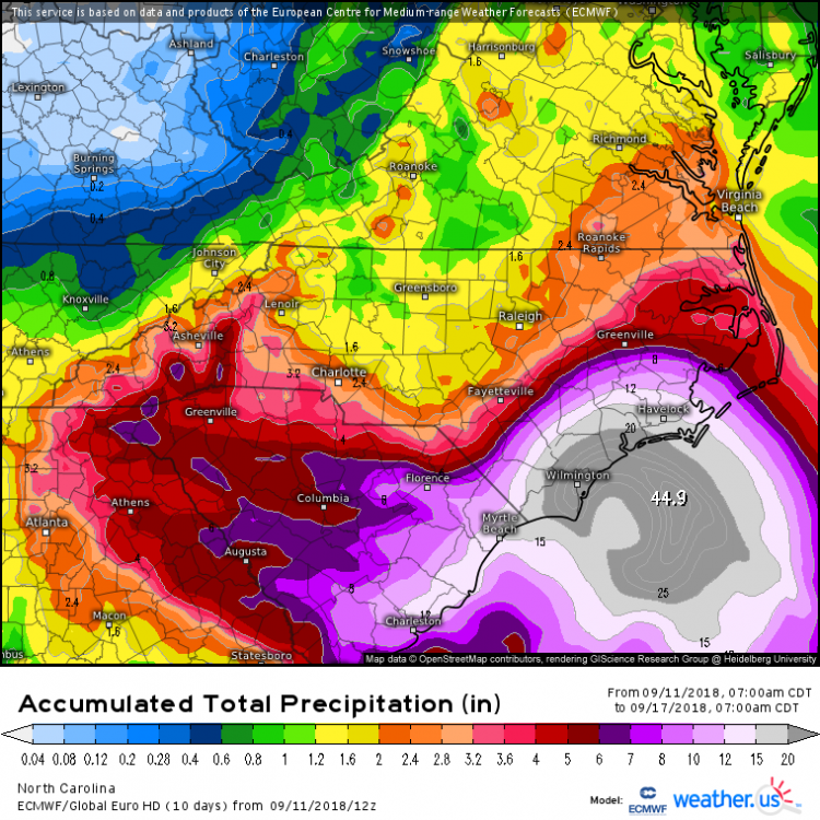
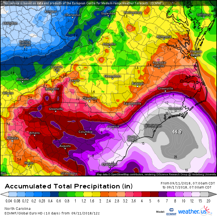
11 inches of rain compared to 35 on the EURO.
-
2
-
-
GFS scenario is actually the best I have seen. It stalls the storm just far enough offshore to miss the worst effects of the eyewall and torrential rain. Still offshore by 120 but bearing down on Charleston as what would be a much weakened system.
-
2
-
-
2 minutes ago, CaryWx said:
Wish I could believe that but this route is still tough for the Triangle. Not catastrophic though
Doesnt look tough to me
-
1
-
-
3 minutes ago, ander420 said:
What would this swap mean for the triangle - just heavy but not epic rains?
A lot less rain. Less than 2 inches for most. A little more towards 95. Very little wind as well.
-
All the college football games cancelling will be eating crow with little to no bad weather if that run happens verbatim.. Just another option on the table. The HP just squashes Flo to the south.
-
The high pressure just squashes it down south this run and it helps that Florence is being shown progressively weaker each model run
-
Inland flood threat west of 95 seems to be decreasing with each model cycle. Especially up my way in Southern VA and towards the triad and triangle.
-
Tropics look to heat up in the 7-14 day range. GFS and EURO have something in the Gulf of Mexico during this time..
-
Looking hot hot hot next week after this brief cool down. Big ridge showing up on most models but looks drier at least for western areas that have been dealing with flooding. Mid 90s most of the week and possible some upper 90s
-
I think it's time for a thread.. The event is only 2 or 2 and a half days away and is on every model to varying degrees.
-
Well the GFS is finally giving NC the bird on this winter..

-
1
-
 2
2
-
-
Robert is chirping about this one on Facebook, think this could be more impressive than last storm. Temperature gradient will be pretty wild. 70s in SC and low 30s at NC/VA border. Could lead to heavy precip
-
Congrats! I will be happy if we get an inch or 2 here. If the dry slot doesn't hit you I think you could get half a foot easy
-
Thunder sleet in Danville and 35!
-
1
-
-
New EURO looks nice for I40 North in NC and southern VA.. 3 to 6 inches for NWNC

-
The pattern is starting to resemble that of February/March 2012... That was a super early spring
-
One thing looks certain.. the drought conditions many piedmont areas have been experiencing are about to be gone. Within the next 7 to 8 days 2 to 5 inches of rain looks likely for much of the SE
.thumb.png.94ca82fb06106ec2925dbdb36df4f8c6.png)
-
3
-
-
The upcoming pattern for the next 7 days looks pretty awful if you ask me. Trough is too far west not enough high pressure to our NE for a CAD storm with an active storm track= lots of cold rain for the next 7 days.. Mountains could do well yes but foothills and Piedmont areas will be lucky to get much out of this pattern.
-
Went to bed about 130 or 2 a.m. after feeling pretty good about radar trends, hrrr, etc. Got up at 700 a.m. to see it snowing huge flakes for a bit before going to work and watchin it transition to better ratio stuff. Was about the same the night before too.. Starting to feel it a bit tonight. Storms are tiring
-
1
-


.png.22cf9a8a4215d377fd43dba97af61907.png)
Major Hurricane Florence: STORM MODE THREAD
in Tropical Headquarters
Posted
This run is definitely further offshore at 96 its at least 75 miles SE of CHS