eaglesin2011
-
Posts
989 -
Joined
-
Last visited
Content Type
Profiles
Blogs
Forums
American Weather
Media Demo
Store
Gallery
Everything posted by eaglesin2011
-
Here you go... This should make you feel better... As of now there is about a 5% chance of 2 or more inches..lol

-
Your disappointed? At least there is a chance ..lol
-
The Canadian a little more south but not too bad compared to the gfs.
-
Yeah looks colder, hopefully now we dont totally lose the storm and can still squeeze out 1-3 .. This evening's runs hopefully will come into more of agreement...Would be nice if we can get at least a little bump in precip.
-
Been saying it the whole time 1-3 looks to be a safe call but still time for it to go either way from there depending on how strong & where it goes.... I'll wait till the afternoon runs tomorrow.. Looking like the models will move back and forth until this first storm passes.
-
Looks like a model shift south with more of a block coming down close to the lakes.
-
Definitely allot more reasonable totals, still cant really take any of them verbatim until the first storm passes but good to see them all showing snow at some point... Its definitely going going depend on where it tracks & how strong & of course how fast we get & how long we can keep the cold air in place...Also, if we can cash in on the back end wrap around here or not..That is normally when we are able to get the decent totals here. Allot still up in the air for sure..
-
True, its yet to be determined how strong & where this is exactly headed... Its gonna be at that a main factor if we get anything but rain in this area... A total miss, looks pretty doubtful to me at this point.
-
Sure its "modeled" for that but most rain back to snow storms in this area end up with allot of sleet or just plain rain.. Its rarely ever all snow in this type of storm in this area. Where you all located? I'm right outside the Short Pump area ..The rain/snow line sets up right a little more north west from here allot .
-
I dunno, its looking like its gonna be a snow to rain, back to snow ,sort of storm for us. You know how that turns out here most of the time...Its allot of sleet that normaly isn't forecast... Gonna need the perfect set up to make it historic in this area... I'm expecting a mix bag at this point...
-
I'll call it a win if we actually have something to shovel .
-
Not worth throwing in the towel or getting too excited until the first storm passes.....
-
Ha if that happens I'll donate a million dollars to this forum from my mega millions winning ticket on Friday. LOL
-
Yeah the 28th looks to be our best chance for awhile . I cant say I like being in the bullseye this early either..... A jog back south wouldn't be the worst thing at this point. Still think allot is going to depend on how far north the first storm goes to set up this one so probably won't know for sure until that happens..
-
Looks like a disorganized broken up mess to me but guess we will see how it looks in the morning... if it looks like we can squeeze out anything up this way besides rain. .
-
I think its going to make it up here.. If we get hit with the dry slot is the main key... Its showing up in this area on most models right now
-
Ha ha. . It does look more north and a bit better put together...again it's all gonna be where the heavy band sets up and what makes it past the mountains/dry air.. Radar hallucinations till then...
-
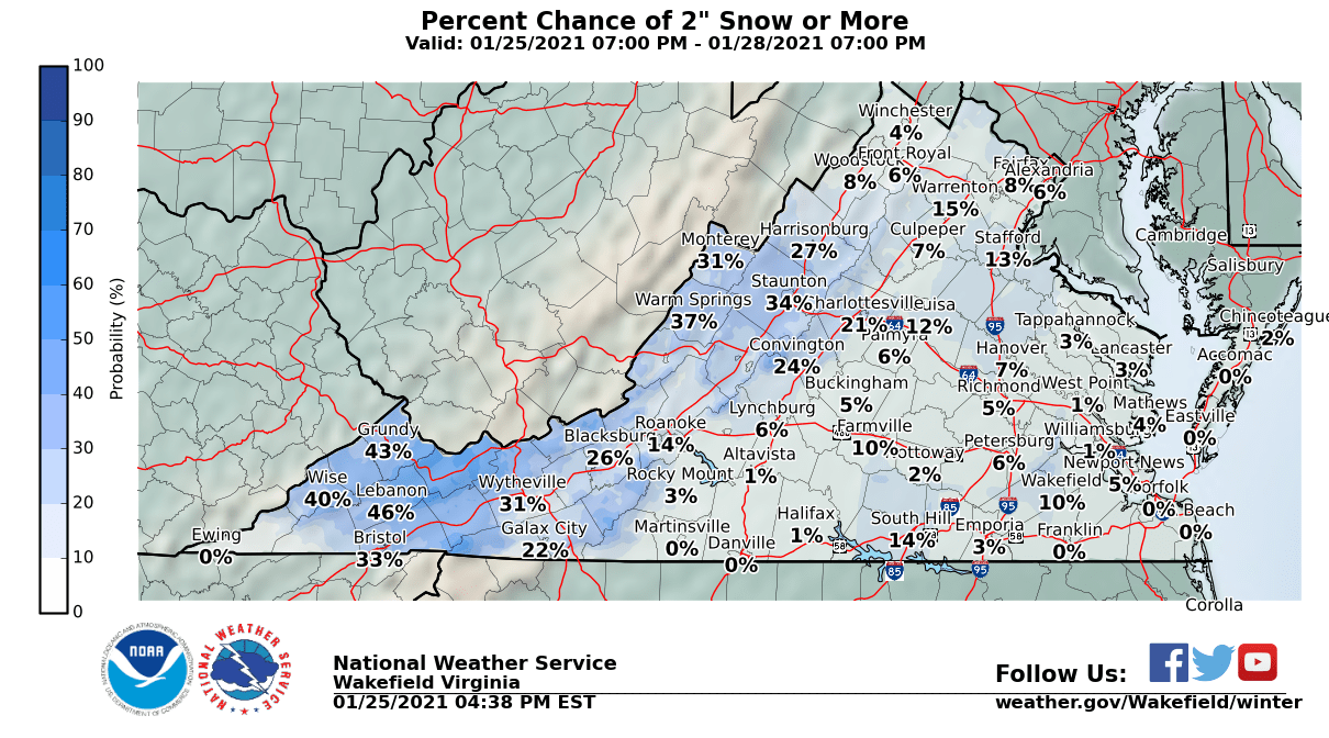
Definitely gonna go from jackpot to almost nothing wherever this hits. Gonna sux watching all that moisture come right at us only to be eaten up by the mountains and dry air... Definitely gonna be a close one. For what its worth wakefield upped the percentage a tad for at least an inch in most places.
-
Models backed off again a bit but damn the weather birds sure are chirping away this morning ... So something maybe coming.. hmmmm..
-
Would nice to get more then a dusting/car topper... Trending a little better lately on most of the models but here are the current predictions from NWS
-
Yeah cmc also showing a decent hit. Still would like to see it not so scattered morning runs should give us more of a good idea...
-
Normally we would be sitting in a good spot this early in the week but trends really haven't gone back in our direction yet.. Still time for a bump north but cant say odds are with us.. Dry air always seems to make it's way in around here..
-
Just mood flakes here in my part of Glen Alen Va, temp staying around 34,had a dusting now melted. Owell
-
Almost always on the edge here.. Everything needs to line up temps/dry air vs precip... Guess we will know more by this time tomorrow Lol..
-
Looks like here in the Richmond area things already starting to wind down just looks like a little more of steady rain in this area. The severe weather looks to have moved more away from this area. Havent really got any decent wind gust yet will be interesting to see if we are too far from the center to get anything of anything of significance.