eaglesin2011
-
Posts
989 -
Joined
-
Last visited
Content Type
Profiles
Blogs
Forums
American Weather
Media Demo
Store
Gallery
Everything posted by eaglesin2011
-
My apologies I was looking at the Rchmond forecast . I'm in Short pump and still have a winter storm warning here .
-
Also thhis area was downgraded to a winter weather advisory for 2 to 4 now. They are obviously going with the GFS.. Hope we can hold to that much at this point...
-
I assume most of if not all is front end snow? Do you have the breakdown Cant say I can believe them bigger totals here...unless we get some back end snow, or if we somehow dont change over here as long.
-
I'm pretty much done looking at all model outputs at this point. I think we are pretty much locked in for 2-5inches. If we can avoid the changeover/ dryslot and get the right track, this could easily double...If the changeover comes in quick then we will most likely be on the low end, maybe even less then 2 inches .(unless we get lucky with the backend) Enjoy whatever snow we get ..It may not be around long.. lol At least the last few models are trending a little colder..
-
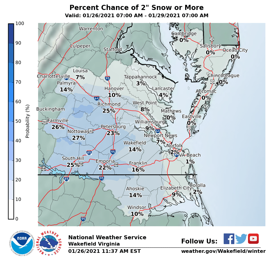
Well we are officially under a Winter Storm Watch .. for 2-5 inches lol Winter Storm Watch from SAT 10:00 PM EST until SUN 7:00 PM EST Action Recommended Make preparations per the instructions Issued By Wakefield - VA, US, National Weather Service Affected Area Portions of central, east central and north central Virginia Description ...WINTER STORM WATCH IN EFFECT FROM SATURDAY EVENING THROUGH SUNDAY EVENING... WHAT...Heavy snow possible. Total snow accumulations of 2 to 5 inches possible. In addition, sleet and freezing rain may result in ice accumulations. WHERE...Portions of central, east central and north central Virginia. WHEN...From late Saturday evening through Sunday evening. IMPACTS...Plan on slippery road conditions. ADDITIONAL DETAILS...A Winter Storm Watch means there is a potential for significant snow...sleet...or ice accumulations that may impact travel. PRECAUTIONARY/PREPAREDNESS ACTIONS... Monitor the latest forecasts for updates on this situation. Hourly Forecast
-
A nice reference here for multiple day/ big storms in RVA Including the 2016 11.4 inches About 6.1 inches day one About 5.3 inches day 2 https://www.google.com/url?sa=t&source=web&rct=j&url=https://glenallenweather.com/upload/richmondclimate/richsnow/GreatestSnows.pdf&ved=2ahUKEwiKlpSP2sHuAhWkFFkFHcBbBEwQFjADegQIChAB&usg=AOvVaw0auXBTqpNuLh8C3TmLc-aB Fyi... <You will need to download to see info >
-
Can someone post the models predictions for the front and back end dumps.
-
I dont think any of these models can accurately predict the front & back end accumulation yet...with all the mixing or just plain rain that could happen.. it's all going to depend on where this storm sets up a few miles can make a huge difference. I expect a few hours of snow, then mix to rain, then back to a mix/snow when it pulls away.. If we even get the wrap around. 3-5 seems like a good total call for the RVA area but nobody really knows for sure yet. Could easily be nothing or more
-
For once I rather be dry slotted if the other choice is a rain/mix if we can get that front end hit to verify first of course...
-
Yeah, I was just about to post that. Would be nice to get a few more bumps south .. Also, on the other models ...
-
At least they are trending a little more south still not enough to help us much. Depending allot on the front&back end of this storm... in between isn't pretty
-
Congrats you southern folks on this first storm.. Just a heavy dusting/car topper here.. I'm content at this point to enjoy whatever snow we get on Sunday, even if it will only be around a few hours.. Would be nice to get a good front end thump .. I will be happy if we can get 2 to 3 inches before the changeover.. Anything after that will be a bonus. Just hope we can avoid a ice storm
-
Not liking the dry slot showing up on a few models ...
-
If it makes it into the Richmond area it won't be until around 2am anyway..
-
Clouded up rather nicely ahead of this first system... Prob have hit the high of the day, so that's also a good thing.
-
Sundays system looking more and more to me like a sleet/rain fest after the first few hours of snow... Hopefully we can luck out.. Need to have it drop a bit more south and off the coast a bit more... I think this first system tonight/tomorrow will give us a clue if this north trend is real, if its able to make it up here with some decent precip...
-
The radar hallucinations does look nice out west, but we will see how much transfers over and if the heavier precip it can inch up this way more.. At least it's coming in over night, hopefully temps crash fast. .. Ha,watch us get more with this then Sunday's system..lol
-
I dont doubt that this ends up being a rain to snow event.. Normally always happens here in big storms.. We definitely should push for more of a southern trend . It may not end up being as big of a storm but at least it wouldn't be as much mixing. I can see a major sleet event here.. Hopefully that dosnt happen...
-
Gonna really depend where that moisture sets up that's coming in near Memphis TN ... Its holding together so far but will get pulled into the coast system. Will be interesting to see how it plays out...
-
Snowing near the coast of Oregon so maybe a good early sign for us later this weekend .
-
Are we still talking about tomorrow? Who cares...Until we completely lose Sunday's storm too.. I personally still think we can squeeze out a 1-3 inches in a few places. .lol
-
I'll like it more if we can actually squeeze out somehow 2 to 3 on Thursday..lol
-
Yeah, let's pretend we never saw this.. 5 days out still lol
-
Our luck we will get that dry air or a sleet fest.. Thankfully still a few days out ...
-
Not completely throwing in towel for Thusday ..Of course I never thought it was going to be much more then a 1-3 storm ,so not as upset as some in here.. Who knows about Sunday-Tues. will suck if we get snow....then have it washed away just a few hours later. Guess we can hope for another southern push but not as much as Thursdays storm that we dont completely lose it or get dry slotted. I'll wait till 24hours out to believe what the models are spitting out...