

OSUmetstud
-
Posts
16,433 -
Joined
-
Last visited
Content Type
Profiles
Blogs
Forums
American Weather
Media Demo
Store
Gallery
Posts posted by OSUmetstud
-
-
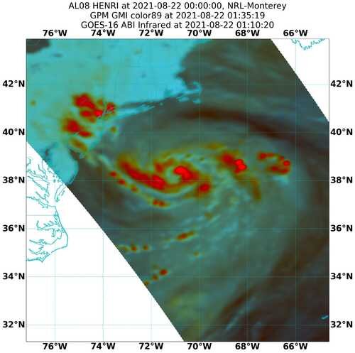
Advanced Dvorak Technique doesn't always best describe it...
On a serious note, that's a nice demonstration of the NW of track deviation that has been observed of late.
-
 1
1
-
-
1 minute ago, Master of Disaster said:
Isn't that kinda high for a Cat 1?
It is, it may not be a cat 1 anymore.
-
4
-
 2
2
-
-
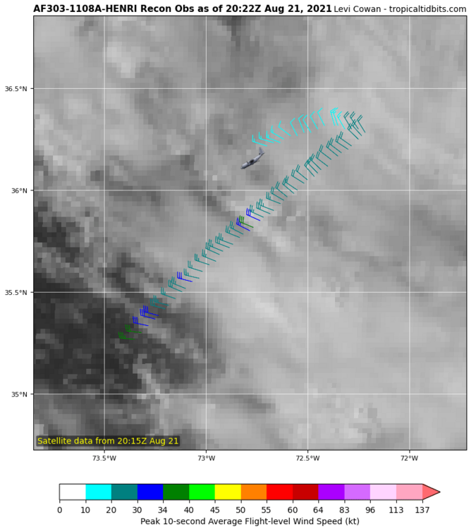
raw Advanced Dvorak Technique is up to T5.6. It's clearly strengthening. Just have to confirm how much via next recon.
-
10
-
-
125 mph
125 mph
950 mb
S of Morgan City
-
2 minutes ago, WxWatcher007 said:
Latest VDM still has the eyewall open
Product: Air Force Vortex Message (URNT12 KNHC)
Transmitted: 28th day of the month at 14:24Z
Agency: United States Air Force
Aircraft: Lockheed WC-130J Hercules with reg. number AF97-5305
Storm Name: Ida
Storm Number & Year: 09 in 2021 (flight in the North Atlantic basin)
Mission Number: 9
Observation Number: 21 ( See all messages of this type for this mission. )
A. Time of Center Fix: 28th day of the month at 13:57:50Z
B. Center Fix Coordinates: 24.74N 85.93W
B. Center Fix Location: 252 statute miles (405 km) to the WNW (297°) from Havana, Cuba.
C. Minimum Height at Standard Level: 2,959m (9,708ft) at 700mb
D. Minimum Sea Level Pressure: 985mb (29.09 inHg)
E. Dropsonde Surface Wind at Center: From 200° at 9kts (From the SSW at 10mph)
F. Eye Character: Open in the northwest
G. Eye Shape & Diameter: Circular with a diameter of 24 nautical miles (28 statute miles)
H. Estimated (by SFMR or visually) Maximum Surface Wind Inbound: 57kts (65.6mph)
I. Location & Time of the Estimated Maximum Surface Wind Inbound: 34 nautical miles (39 statute miles) to the SSE (153°) of center fix at 13:48:00Z
J. Maximum Flight Level Wind Inbound: From 236° at 57kts (From between the SW and WSW at 65.6mph)
K. Location & Time of the Maximum Flight Level Wind Inbound: 27 nautical miles (31 statute miles) to the SSE (154°) of center fix at 13:50:00Z
L. Estimated (by SFMR or visually) Maximum Surface Wind Outbound: 63kts (72.5mph)
M. Location & Time of the Estimated Maximum Surface Wind Outbound: 15 nautical miles (17 statute miles) to the NW (311°) of center fix at 14:02:30Z
N. Maximum Flight Level Wind Outbound: From 51° at 59kts (From the NE at 67.9mph)
O. Location & Time of the Maximum Flight Level Wind Outbound: 21 nautical miles (24 statute miles) to the NW (311°) of center fix at 14:04:00Z
P. Maximum Flight Level Temp & Pressure Altitude Outside Eye: 11°C (52°F) at a pressure alt. of 3,037m (9,964ft)
Q. Maximum Flight Level Temp & Pressure Altitude Inside Eye: 12°C (54°F) at a pressure alt. of 3,042m (9,980ft)
R. Dewpoint Temp (collected at same location as temp inside eye): 12°C (54°F)
R. Sea Surface Temp (collected at same location as temp inside eye): Not Available
S. Fix Determined By: Penetration, Radar, Wind and Pressure
S. Fix Levels (surface & flight level centers within 5nm of each other): Surface and 700mb
T. Navigational Fix Accuracy: 0.02 nautical miles
T. Meteorological Accuracy: 1 nautical mile
Remarks Section:
Maximum Flight Level Wind: 72kts (~ 82.9mph) which was observed 34 nautical miles (39 statute miles) to the NE (43°) from the flight level center at 12:31:30Z
Maximum Flight Level Temp: 14°C (57°F) which was observed 7 nautical miles to the SE (135°) from the flight level centerIt looks like mission 8 is getting more impressive readings overall for whatever reason.
They had 983 mb with a 16 kt wind at splashdown along with flight level winds of 82 knots and SFMR of 67 knots.
-
3
-
-
26 minutes ago, Tezeta said:
We should have stuck to the NATO alphabet
Hurricane Whiskey and X-Ray seem fun.
-
If the NHC didn't want regular folks calling storms "he" or "she" then they probably shouldn't use a list of names that clearly alternates between male and female sounding names. I know its more properly an "It" but I understand why people would call it a "she" or a "he."
-
2
-
-
4 minutes ago, RUNNAWAYICEBERG said:
Yea. It will tick east a little unfortunately putting NO in the NE quadrant upon LF. Bad news.
Most of the guidance just seems a bit too far away to give New Orleans the worst. The bend left near the coast helps them a good deal. It looks like Morgan City and Lafayette is in the cross-hairs.
-
4
-
-
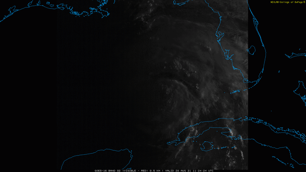
First light
-
2
-
-
1 minute ago, csnavywx said:
That would explain the series of opposing cycling hot towers a little while ago -- probably fired along the major axis.
It does seem right on the edge of taking off, there was a cyan ring in the 37 Ghz at 07z.
-
7
URNT12 KWBC 281019
VORTEX DATA MESSAGE  AL092021
A. 28/09:44:45Z
B. 24.06 deg N 085.26 deg W
C. 700 MB 3035 m
D. 987 mb
E. 195 deg 08 kt
F. OPEN SE
G. E03/35/10
H. 53 kt
I. 307 deg 16 nm 09:40:49Z
J. 052 deg 52 kt
K. 307 deg 22 nm 09:39:16Z
L. 63 kt
M. 133 deg 14 nm 09:51:04Z
N. 225 deg 66 kt
O. 132 deg 15 nm 09:51:11Z
P. 10 C / 3067 m
Q. 14 C / 3053 m
R. 10 C / NA
S. 12345 / 7
T. 0.01 / 0.5 nm
U. NOAA3 0809A IDA OB 07
MAX FL WIND 66 KT 132 / 15 NM 09:51:11Z
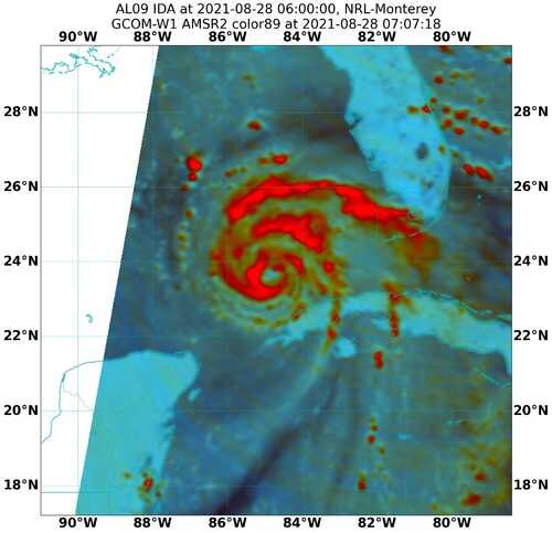
Weird eye shape there, elliptical with a 30-210 degree axis, 10 NM by 35 NM.
-
-
3 minutes ago, WhiteoutWX said:
I don’t remember how models did with Rita but they’ve been tightly clustered on a landfall location with this one the last day or so. I think track confidence is fairly high at this point. Margin for error is still probably big enough for New Orleans to miss out on the worst of it, but still seems prudent in this case to give people more time to evacuate than wait for a last second scramble when it’s too late, especially given the potential for a major upon landfall.
The probably with Rita if I remember correctly is how massive the stated evacuation was and some bad communication where far too many people from Houston on high ground evacuated who shouldn't have.
-
3
-
-
9 minutes ago, csnavywx said:
The diabatic pump is real, however I think *at the moment* it's more about the differential steering flow (versus a weaker/shallower and more tilted Ida that some ensembles and deterministic runs had forecast). This constant slight deviation to the right of track adds up over time -- at least until the shear vector weakens and shifts direction late tonight and tomorrow morning.
The effect might cancel out -- but we could really do with fewer corrections to the east.
Right, I guess I wasn't sure how much the shorter term jogs to the right would affect the final landfall location, given that the forcing latter should be left.
-
The synoptic pattern to me suggests that stronger=west. I think a stronger Ida ends up diabatically building that ridge to the northwest of it.
-
6 minutes ago, Ginx snewx said:
Nice, almost looks like IRC which would spread out the winds

There's a double wind max on recon.
-
2
-
-
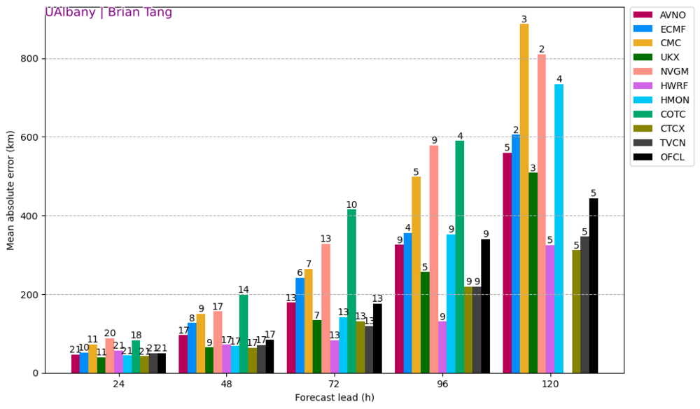
Brian Tang's MAE analysis is showing HWRF having the best performance with this storm so far, at basically all lead times.
-
2
-
2
-
-
a bit over an hour ago. Symmetrical, with banding, but no proper CDO or bonafide eyewall.
-
4
-
-
6 minutes ago, CoastalWx said:
RI in the cross hairs.
An accordion plays, gently
-
1
-
 10
10
-
-
6 minutes ago, WxWatcher007 said:
Unflagged 66kt SFMR on this latest pass NW to SE. SE has consistently been the strongest part of the storm.
That's the first time it's had hurricane-force SFMR
-
1
-
-
You know the storm is going to be weaksauce when the majority of the talk is about many people are going to lose power.
-
2
-
3
-
-
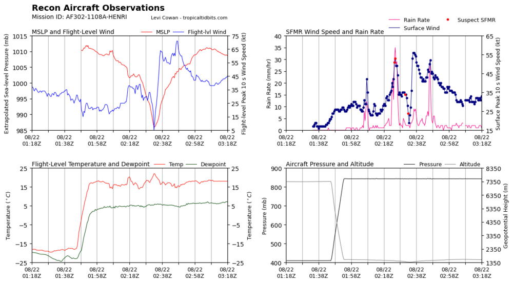
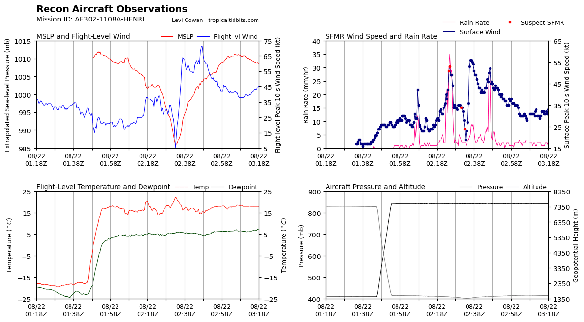
Latest extrap pressure is 984mb on the recon. Certainly has been deepening today, fallen about 10mb or so from this morning. No stronger winds found yet though.
-
1
-
-
Recon mission 12 will be there in an hour or so.
-
Henri was just too ferocious, had to turn back.
-
7
-


Major Hurricane Ida
in Tropical Headquarters
Posted
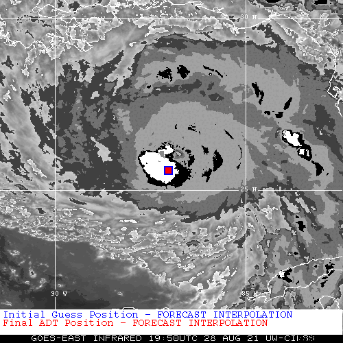
That's what it's showing. The forecast interpolation is SW of the actual position, therefore its intensity estimation is crap.