

OSUmetstud
-
Posts
16,433 -
Joined
-
Last visited
Content Type
Profiles
Blogs
Forums
American Weather
Media Demo
Store
Gallery
Posts posted by OSUmetstud
-
-
4 minutes ago, SnoSki14 said:
The most likely scenario is OTS obviously but that's always the easiest call to make.
Lol
-
 2
2
-
-
1 hour ago, SnoSki14 said:
Well I would rather not have a hurricane impact the area so OTS is best.
That being said it's premature to say this will harmlessly go OTS at this stage.
Enough. I'm a meteorologist who does this for a living offering my thoughts on what I think the most likely scenario is.
-
 3
3
-
-
8 minutes ago, MJO812 said:
Agree
This is why I'm laughing at everyone already throwing in the towel.
I'll be sure not to offer my thoughts next time on the most likely scenario since you and sno ski don't like it.
-
 1
1
-
-
9 hours ago, Hazey said:
Sam looks about to take off. Impressive already.
Hey Nick, Are we gonna have to watch this up here?
#NovaScotiaStrongI dont think so. The central Atlantic ridge is tending to weak. I think it affects bermuda and exits right.
-
1
-
-
Just now, Normandy said:
Can you explain this a little more? That's not how I am reading this and want to be schooled on how I am interpreting this. See tweet below for what I am seeing:
Every single member of the eps didn't make landfall. I'm not surprised that Eric compared a single op run to a hugo plot...and the storm still missed...
Most of the guidance has the trough sitting on the east coast not cutting off that far southwest...and a trough in the position makes sense with a massive ridge over Ontario.
-
500mb is just all wrong for a US landfall. Theres a trough where you'd want a ridge and a ridge where'd you want a trough. So much has to change for it to happen. I'd put it at less than 10 percent...and that might be generous.
-
2
-
 2
2
-
-
25 minutes ago, Vice-Regent said:
So true brother. Those 12z Euro ensembles are just coming out are revealing to say the least. Being west or east of the mean track at 9 days is a good thing if you like tropical cyclones.
West or East? So anywhere?
-
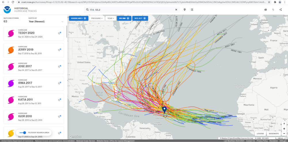
It really doesnt look all that different. This include tropical storms. The other graphic just included hurricanes.
-
10 minutes ago, Tezeta said:
Why would your starting point be a day 5 projection subject to forecast error instead of where the storm is now? Oh wait, because that’s less fun and has a way higher percentage of OTS.
unamed 1893 would be alright tho…looks like the only realistic post 9/20. I personally would like to see inez 2. That would be an insanely fun storm to track.
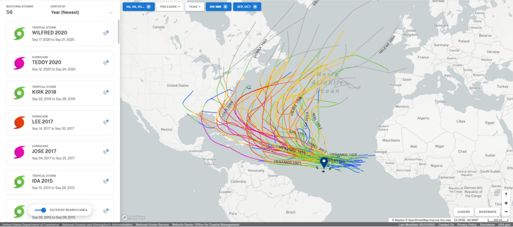
lol I didn't even look at that. I was just curious where from Day 5 onward it would look like. The average track error at Day 5 is 172 NM so it's not completely without basis. I mean you could run all storms from the current point and see what it looks like if you want.
-
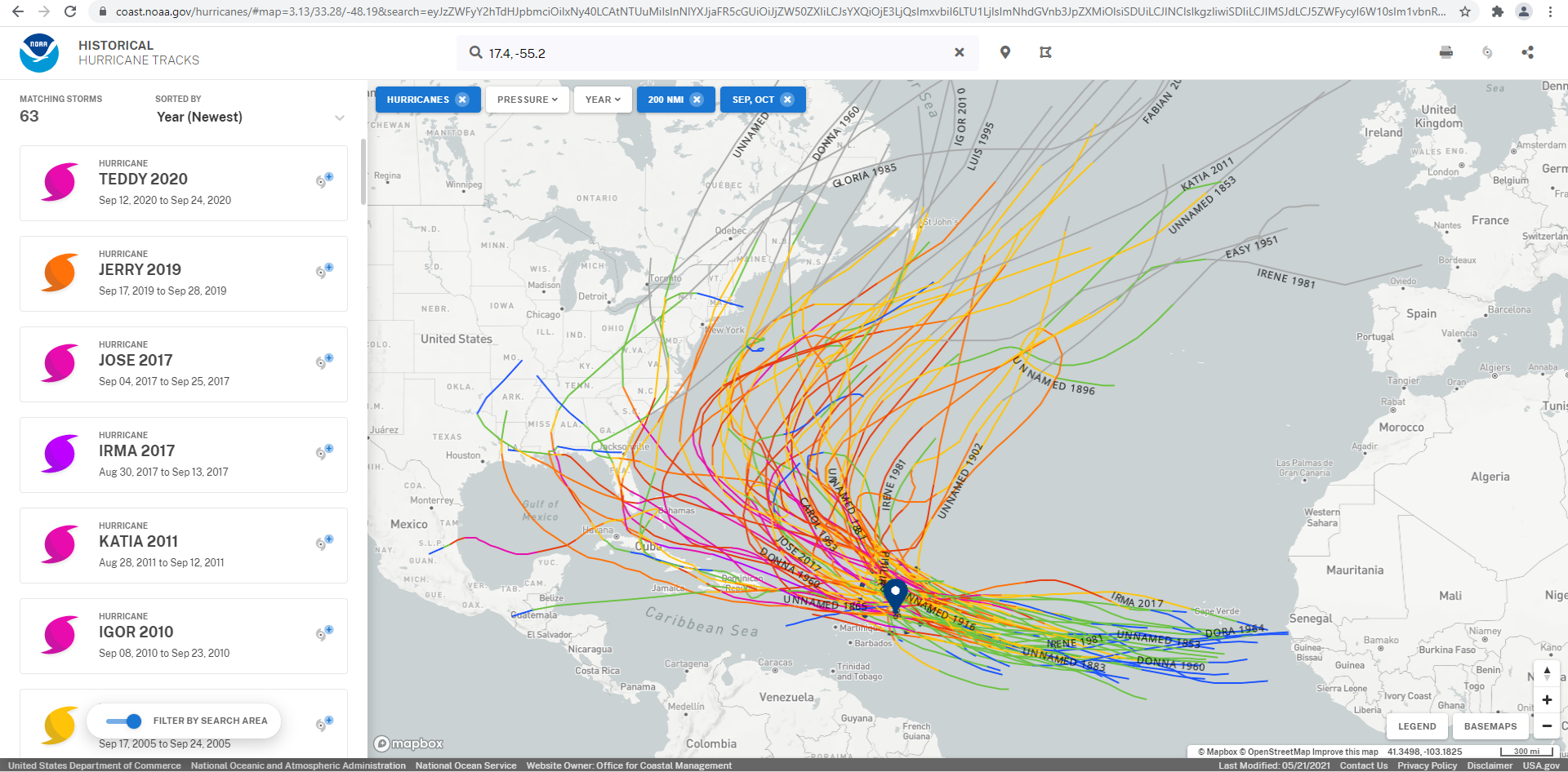
These are the historic tracks in September/October within 200 NM of the NHC day 5 forecast point. Most recurve out to sea, a few makes to the US southeast, a few to the US northeast, and a few to Atlantic Canada.
-
3
-
 2
2
-
-
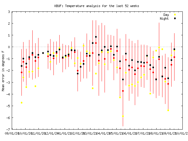
BUF is running warm, about +2F this summer. It's more likely an instrument issue than UHI.
-
2
-
1
-
-
18 minutes ago, csnavywx said:
How was it up there -- as compared to say a strong mid-winter cyclone?
The winds here were probably like a 1 in 10 to 20 year event. We gusted to 85 knots in a March 2017 low that was 952mb or so and came up the same bay as Larry and that was strongest wind gust here in 40 years. It's the second highest gust for a TC here on record behind Ione in 1955. Far more damage than the March 2017 windstorm though. Probably second behind our snowmaggeden super blizzard in Jan 2019 in terms of anomaly and overall impact.
-
3
-
-
The surge on Placentia Bay (about 5 ft or so above high tide) might be one of the most impressive aspects of Larry.
-
6
-
-
Hurricane warnings are now up for the Avalon Peninsula given a track adjustment westward over the past day or so.
-
2
-
-
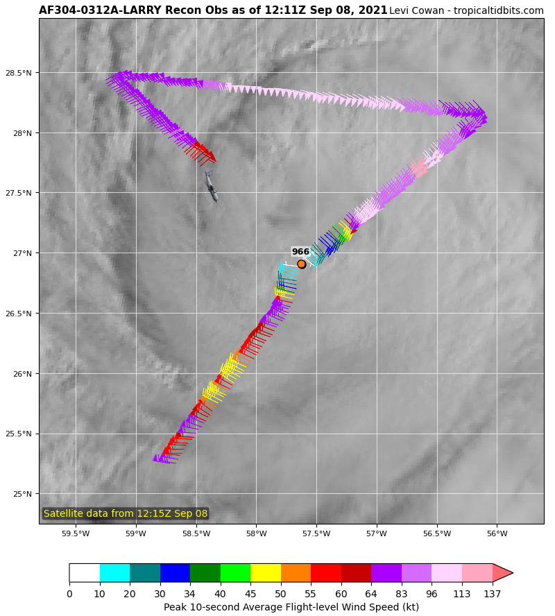
15 minutes ago, Windspeed said:40 minutes ago, olafminesaw said:Seems typically with a large, tilted, fast moving system you tend to see more wind field expansion than an increase in max winds. But I suppose possible the eyewall could reorganize somewhat
Agreed. My post is intended to give a ceiling for any potential reintensification. It would still be tough for Larry to regain major hurricane status given its broad windfield. Most likely it may just become more efficient at mixing down winds to remain a hurricane. Perhaps regain Category 2 intensity at best. Current maximum winds on the 11AM AST advisory is 90 mph sustained.
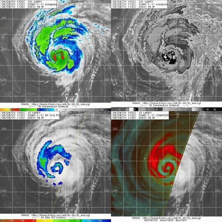
Yeah I'm a little annoyed as this idea that it's weakening from the NHC. I think it was overestimated yesterday based on SFMR and lack of convection. So this morning's data is more indicative of its real intensity. It may have actually been weaker yesterday. The pressure fell 2mb in 95 minutes between passes and the microwave looked nice this morning.
-
5
-
-
52 minutes ago, jconsor said:
Thanks for the local perspective, Nick @OSUmetstud! Appreciate it very much. What's your Twitter handle? Mine is @yconsor. I've also been posting some updates on potential Newfoundland impacts from Larry there.
-
What is wrong with this thing?

-
Just now, Scorpion said:
I’d love to experience a hurricane up there sometime. Beautiful northern forest and hurricane force winds. Would just set myself up on an exposed ridge on an observation tower. Probably be hard to stay warm though.
Night time for potential landfall unfortunately.
-
I usually do most of my weather stuff on twitter nowadays but I'll provide some updates.
The bifurcation between the gfs emcwf and gdps and their ensembles compared to the hmon hwrf and coamps is interesting. Hurricane models are near or just east of the avalon whereas the globals track over placentia bay/western avalon Peninsula. Makes a huge difference re: wind damage.
This is not Igor. Igor was basically fully et/post tropical. It had been embedded with a 500mb trough in excess of 12 h...so much so that even though it made landfall in Cape Race it produce hurricane force winds all the way back northwest to Bonavista. Strong winds with Larry will be mostly found east and south of track. Also, rainfall doesn't appear to be a big deal with this one which was really Igor's most damaging element. The stationary front is well to to west over the Maritimes and not in east central Newfoundland like it was with Igor.
If Larry does take the western avalon/placentia Bay track than the wind damage could be worse for stj and the avalon than it was for Igor.
-
1
-
1
-
-
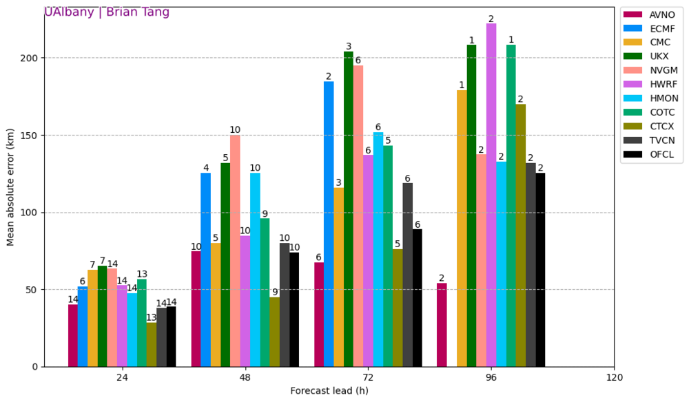
Gfs had the least track MAE of any of the operational models. The three bars to the right are concensus blends.
-
1
-
-
5 minutes ago, Tezeta said:
You sweating yet? I know you’re reading all the posts about catastrophic power failures…
I don't think those equivalent to Laura in insured losses calls are looking good right now either...
-
1 minute ago, forkyfork said:
hundreds of dollars in damage
the shrimp industry will be decimated for sure
-
Just now, Tezeta said:
It’s a complex system. Yes it has been revamped but why anyone would 100% trust any piece of infrastructure in America of all places is just beyond me.
Also it’s not just about levees. What if a chemical plant blows 2 hours from now? There’s lots of catastrophes that can still happen.
Oh sure. I'm just saying that from what we've seen today, I think they'll be alright. Am I not allowed to give an opinion on it?
-
Katrina was a semi-man made disaster. This will actually be worse for a lot of areas in SE LA than Katrina was, meteorological speaking. The surge in NOLA will actually probably end up similar. The thing that's different is the levees.
-
2
-
1
-


Major Hurricane Sam
in Tropical Headquarters
Posted
It's just flashes. The GLM is an optical instrument. Doesn't know what type of lightning.