

OSUmetstud
-
Posts
16,433 -
Joined
-
Last visited
Content Type
Profiles
Blogs
Forums
American Weather
Media Demo
Store
Gallery
Posts posted by OSUmetstud
-
-
Just now, A-L-E-K said:
Zzzzzz
An Andy Dalton led offense? Yep.
-
 2
2
-
 1
1
-
-
8 minutes ago, jbenedet said:
Significant expansion of the wind field right upon closest approach, as phase completed. AWT. New England being New England.
Model huggers flummoxed.The whole northeast and Ma is awash in warm air at the low and mid levels. There just isn't much of an ET assist here. Very little baroclinicity.
-
3
-
-
I'm assuming this track is bad for Narragansett Bay? The winds kinda stay out of the south/southeast because of the angle of approach.
-
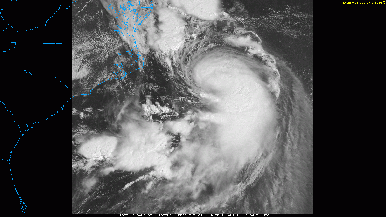
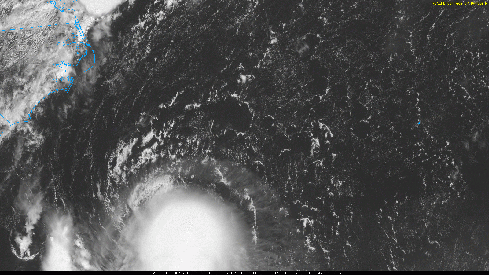
I can see on a eye on the vis now.
-
 1
1
-
-
Just now, CoastalWx said:
Yeah will it? It seems Awfully tight for something our latitude.
Idk. The recon this morning had a bit less of that e wind maximum as it had tightened and become more stacked. I think it will be small for new England TCs but probably better on the east side than the modeling would suggest
-
I lost power for almost 2 hours last night in thunderstorms. By far the best show in my 6 years here.
-
3 minutes ago, CoastalWx said:
Amazing how tight wind field is
I guess the idea is that it will shed off the east wind maximum as it reorganizes and strengthens? Because last night that's where the strongest winds were...like 85 NM SE of the center.
-
Just now, Typhoon Tip said:
You seem to have a learning disability - or perhaps a histrionic disorder which over a dacade of on and off exposure to your jest really evinces this is your problem.
When it comes to comprehension. You miss interpret sardonics/sarcasm and drool cynicism as literal, and take things to a distraction because you merely don't like what you read - miss the point.
So .. no, I will not shut the f up based upon your limitations.
Sorry. You are more than welcome not to read, block me, or log off. Do what you want. I think it would be easier to lighten up.
You are literally making up conspiracy based on bullshit. Dont try to justify it to me.
Both the news station making up track guidance to fearmonger and the nhc nudging intensity are completely fact free crap that you use to wow us with your psychobabble.
-
1
-
-
Just now, CoastalWx said:
Yeah was thinking not great looking.
I mean that literally lol. With the feet sticking out toward NC. Or a fetus perhaps.
-
2
-
-
4 minutes ago, USCG RS said:
That actually looks healthy...
It looks like a rodent.
-
2
-
3
-
-
-
7 minutes ago, Typhoon Tip said:
Yeah... the NHC agenda is entirely disconnected and not apart of the IMC ( industrial media complex) - lol.
I am not impugning NHC at all.
In fact, their hands are cuffed -wtf are they supposed to do. They are charged with informing of these sort of calamities to a society with dimmed hearing because the din of pop cultural stimulus has it that no one can really hear the "urgency" if they are even looking.
So yeah, sit and wait and ... add 5 mph so that hurricane can take the podium and the flashing lights and "Twits" in the audience will look up from their iPhone - proverbially speaking.
I wish some RECON pilot would spill the 'soft conspiracy' that they are routinely phoning in 70 and getting 80 out of NHC's decision makers but, that's sci-fi paranoid talk... ( seriously, don't take that j/k)
anyway, the IMC is purely about money and needs some sort of non competitive but financed ( somehow ) media alternative - such that people can choose from it, or CNN/FOX/ABC/NBC/CBS fab five of marketing stimulus oil for lubing their Machiavellian economic engine.
Can you shut the **** up?
-
4
-
 1
1
-
6
-
-
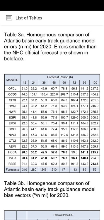
This was last year's track model verification for those curious. Gfs outperformed the euro at most lead times.
-
5
-
-
1 minute ago, PowderBeard said:
Literally just had this convo with my wife. There is such a psychology piece to this. I would like to think it is about getting people prepared "just in case" but I'm sure it is all about clicks, likes, and views. If you're a little off and it is not as bad, whatever, the weathermen are always wrong. But if you're right, people remember and then you have a viewer/subscriber for life.
The stations are running their graphics from official sources.
-
2
-
-
4 minutes ago, Typhoon Tip said:
It's comical how each forecasting source/geography is taking ownership of the track guidance. It's making actually giggle. All these offices ( media ) have software and skill to formulate their own graphics these days ... so, they plug the ensemble member into the graphics engine that is the most dystopian excitement for ratings?
That's what it comes off as. I have not seen a concensus that supports that far West, and noting about now cast evinces that as the most likely either. All there is, is a couple ensemble members from whichever lusty appeal doing that.
The problem is a sociological one. Media has come to an understanding that there are no penalties for false impressions - the forgetfulness of feckless society becomes a marvelous buffer. However, there is huge huge pay-back dividends for getting it right if they roll dice on a scenario and it happens to come true. It's like all of corporate media engages in Bastardiism
It's the nhc track. Come on.
-
1
-
4
-
-
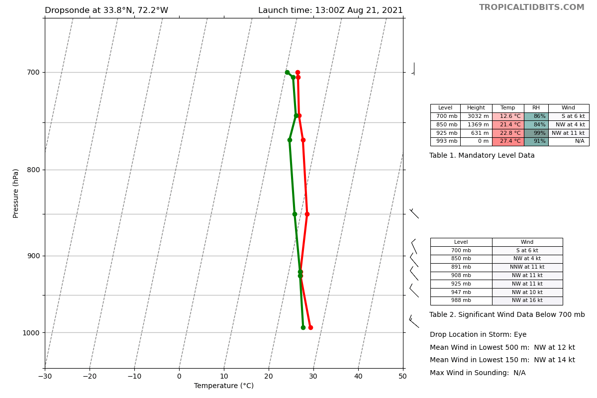
Pressure has been falling a bit this morning. Some conflicting data from the dropsondes but maybe somewhere below 990mb now.

-
1
-
-
Just looking at the ships products I think the window to strengthen closes near or just before 06z tonight. Conditions are solid between now and then...its more about the storm at this point than the environment.
-
1
-
1
-
-
new ukmet tracks from Eastern LI into NY/CT/MA border area.
-
1
-
-
3 minutes ago, WxWatcher007 said:
You mean upshear, right?
Agree though--there's improvement at flight level, but not where it matters. Not yet at least.
I thought that shear vector was still out of the north at the moment but either way.
-
1
-
-
1 minute ago, WxWatcher007 said:
Looks like that center did jump NE.

Tough look for intensification...broad center with a large RMW. Need some VHTs to develop downshear of the center.
-
2
-
-
Just now, weatherwiz said:
what products are you looking at to see tilt/stacked system?
You can use your eyeballs on the vis there lol. But microwave would show it also.
-
1
-
-
-
1 minute ago, SnoSki14 said:
Tonight and tomorrow will be the big window. Shear will be really low and environment looks moist.
If this can align then it'll take off fast.
Regardless of what happens the relatively slow moving nature will cause high surge and flooding.
Irene wasn't a hurricane and did tremendous damage.
Yeah Irene was very impressive. Lost trees and got several inches of rain in Blackstone.
It looks very tilted right now albeit organized.
-
4 minutes ago, CoastalWx said:
Euro might be off with strength. But to be honest, I haven't seen these nasty winds that you normally see at 925mb like in previous storms. It's why I was saying the winds are going to be closer to the center vs what we normally would see. The winds are strong near center, but you'll need more than 50kts at 925 to do damage.
It really needs to take off between now and tomorrow to become a real wind event. If it made to a 3 before weakening it would make a huge difference.
-
6
-
Tropical Storm Henri
in New England
Posted