

BlizzardNole
-
Posts
2,936 -
Joined
-
Last visited
Content Type
Profiles
Blogs
Forums
American Weather
Media Demo
Store
Gallery
Everything posted by BlizzardNole
-
Pretty hot day! 85 here. Check out Charlottesville -- never seen that one before LOL

-
80s today and 50s tomorrow with rain LOL. Maryland gonna Maryland
-
Starting out clear and 45, looking forward to a beautiful day. Forecast for next 7 looks great -- no big heat in sight just nice spring temps
-
2023 Mid-Atlantic Garden, Lawn, and Other Green Stuff Thread
BlizzardNole replied to mattie g's topic in Mid Atlantic
I've tried spray repellents and they don't really work long. After having two nice potted plants attacked and destroyed I got these pot grids linked below. You can cut them to size and cover with a thin layer of mulch for looks. The little monsters can't dig in there any more. https://www.amazon.com/dp/B0B31C21XQ?ref=ppx_yo2ov_dt_b_product_details&th=1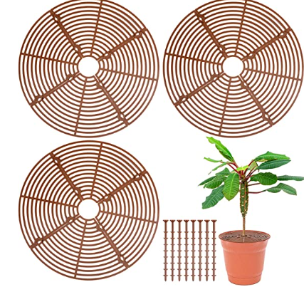
-
Wow where? I got down to 39 and saw a little frost on some roofs. Hopefully no more cold nights because I am ready to get annuals in the ground!
-
Tiny little shower just rolled down 270 and it actually rained pretty good for a half minute. Those ones west of Hagerstown heading SSE look fairly robust. Looking forward to tomorrow's sun and mid-60s
-
My hopes for some sun today are fading as cloud deck has quickly moved in. I hope this is the last cloudy chilly day.
-
2023 Mid-Atlantic Garden, Lawn, and Other Green Stuff Thread
BlizzardNole replied to mattie g's topic in Mid Atlantic
If the 6-10 day and 8-14 day forecast are on the right track with above average temps thru mid-month, we should be safe to plant tender annuals this weekend. Finally! -
Had a quick shower and now some peeks of sun. Just want to get the next couple days of crappy weather (aka Maryland spring weather) over with and hope the weekend forecast holds
-
Sky starting to lighten up and 60 degrees. Does this afternoon end up like yesterday with surprise sunshine? Looks like I got about 0.5 which puts me at near 2 inches since Friday. That's perfect
-
Welp... , here we go again? (from LWX disco): Additional shower chances are expected Friday and Saturday as another wave of low pressure and resultant trough settle into the region. My Huntingtown sister and fam went to OC MD this weekend for kite weekend Accg to maps and nearby reports got about 0.44 overnight to push total to about 1.55 which is perfect especially how spread out it was. Temp seemingly locked at 51
-
All we need is the pivot!
-
Dry slot into southern VA. Lots of bright orange in central VA moving north -- are they mixing? 53 and light rain here, waiting for heavier stuff. Oh and the maple seeds have clogged the gutter
-
I've been watching that as we have a big family event Saturday -- it's looking more and more like we get a break in the rain during the day, and maybe if we're lucky we'll have a few peeks of sun. Temps look nice
-
Agree also. I'm in a bit of a micro-climate where higher elevations from my W around to my NE result in a "shadow" effect where lines and clusters of spring/summer thunderstorms frequently miss or split around. I need to cash in on this synoptic rain
-
2023 Mid-Atlantic Garden, Lawn, and Other Green Stuff Thread
BlizzardNole replied to mattie g's topic in Mid Atlantic
What do you use as host plants to get so many chrysalises? I had a couple clumps of rue and am thinking of adding parsley -
2023 Mid-Atlantic Garden, Lawn, and Other Green Stuff Thread
BlizzardNole replied to mattie g's topic in Mid Atlantic
Now I've got three black swallowtails hatched and one more to go. It's just too cold to release them today and with the big, cold rain coming I am thinking about holding them for a few days. Bad timing for them -
35 with a little frost here and there. Brought all plants in last night I am hoping for 2 inches total in this rain coming up
-
Had our first on April 22 -- a male. My parents in Calvert saw their first one the same day and said it was the fourth straight year that they saw their first hummingbird on April 22.
-
Don't have a gauge but looks like a little more than a half inch based on rainfall maps and local reports. That helps but need more! I hate to do this but I'm hoping for a long duration stratiform rain later this week with one of those southern stream systems. Bright and sunny and 49
-
2023 Mid-Atlantic Severe Wx Thread (General Discussion)
BlizzardNole replied to Kmlwx's topic in Mid Atlantic
Got a good looking line heading in with some lightning. Got both pollen-encrusted cars out in the driveway with some car soap squirted on 'em- 2,785 replies
-
- 2
-

-
- severe
- thunderstorms
- (and 3 more)
-
Nice morning out now with breeze and 60s. Really need rain bad as the last few chances missed and my yard is like concrete and everything is pollen encrusted. I'm a little worried as this is lines and cluster of thunderstorms which almost always miss this area. I need a long duration synoptic rain to cash in.
-
Wow got down to 35. Close call for some plants I left out
-
Overcast creeping in keeping temps down a little - will make for a nice walk in a bit. They are cooking up in New Eng with multiple low/mid 90s I hope we can score some rain tonight
-
2023 Mid-Atlantic Garden, Lawn, and Other Green Stuff Thread
BlizzardNole replied to mattie g's topic in Mid Atlantic
Very nice! I have 5 black swallowtail chrysalises and am keeping them in a cool part of the house hoping they'll wait a few more weeks.


