BlizzardNole
-
Posts
2,947 -
Joined
-
Last visited
Content Type
Profiles
Blogs
Forums
American Weather
Media Demo
Store
Gallery
Everything posted by BlizzardNole
-
I thought I was headed for a dead ratter, but a cluster of thundershowers popped up overhead and I lucked into 0.65
-
Yeah, that round was frustrating. That cell over Lusby 10 miles to my south would have been nice since there's no guarantee on the later stuff. The big gap in the main line is aimed right at us; I hope it fills in!
-
Getting a couple showers moving NE over me as I wait for the main show
-
Sun has been out for a couple hours now, 86/73. I'm really hoping for some lightning after dark tonight. Love that!
-
Cloudy 81/72, been overcast all day. I'm hoping the sun breaks out before the front arrives to stir up some thunderstorms
-
Excellent! Any plans for stations in Anne Arundel and St. Marys?
-
A cool 60 degrees after a light rain of about 0.15. I like seeing no heat wave in the forecast
-
Sunny, 73/59 with a breeze in late July! Meanwhile in NC with more to come yikes
-
Got lucky with some training showers last night and picked up 0.75 for a total of 2.10 for the event. Best rainfall since I moved here in March. Now I'm looking forward to gorgeous weather the next four days.
-
Oh hell yeah I'm looking forward to that! We are going to a local winery for some live music on Friday evening. Should have temps falling thru the 70s Hoping those training showers SW of me make it here
-
A stunning 1.3 which is more than the whole month of July before this! It's also the most rain at one time since I moved to the southern MD desert. We'll need more in the next couple weeks to avoid a seventh straight below normal month.
-
Just got home after visiting away and it's dusty and dry so I watered my plants. P&C forecast thru tomorrow night has 0.5 to 0.75; 0.1 to 0.25; 0.1 to 0.25. My formula is take the minimum and divide in half so 0.35 total expected. Won't be surprised at a shutout though.
-
Decent evening on tap with sunny and 83/64 right now. While I don't expect much if any rain from the front, it's looking like some great weather Thursday through the weekend with upper 70s/low 80s and bright sunshine. Gimme that!
-
Point/click has my rain chances for tonight through Wednesday night of 60%, 70%, 90%, 80%, 80%. I'm calling it now: less than 0.2 total and a total whiff wouldn't surprise me. Too bad that new depression in the Gulf is expected to move west towards Texas. A tropical system up the coast is the only way I can think of that would get real rain here.
-
Yeah, I should have been more clear - I meant that it "should" be a rainy winter with more southern stream lows. But I will believe in mythical rain when I see it in my desert.
-
WOW you probably have more rain this month than I have for the year. Terrible drought continues here with no end in sight. Leaves are dropping now
-
I used to complain about Germantown being dry LOL. It's got nothing on the full-blown desert that is southern Calvert. Radar is now clear that no rain will fall here again today and it won't next week either. We won't get real rain here until late fall when we start getting those nino-fueled Gulf lows.
-
Based on radar, I will be out watering the garden later
-
That concert indoors? I know there's another concert at Ravens stadium tonight and that could get interesting with big t-storms. 85/78 here with the blue sky starting to show with southerly winds pushing the smoke out.
-
Nothing but smoke and parched ground here. I'm not expecting any rain this evening either
-
My niece and a friend are going to a concert at Ravens stadium tonight. Eeeek
-
93/77 Hx 107 but it feels hotter out than the 100 degree days we had. Just nasty We are halfway through met summer. I will be happy to see September
-
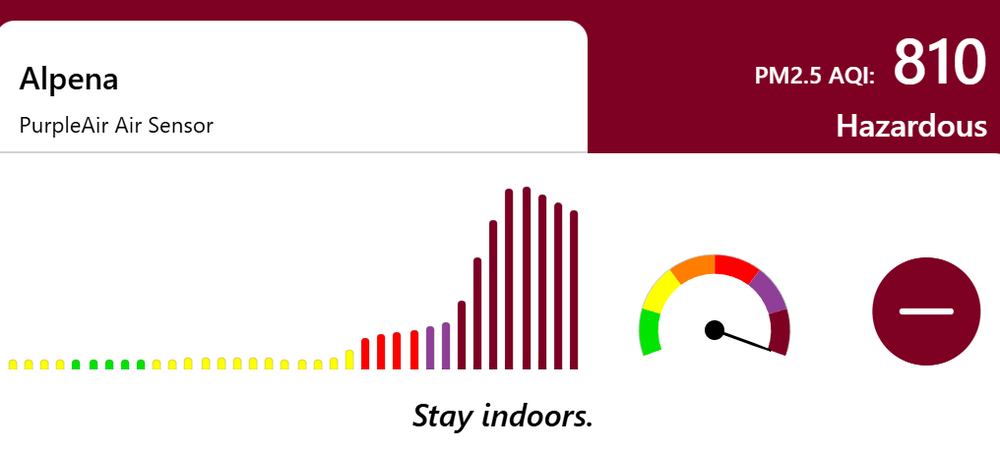
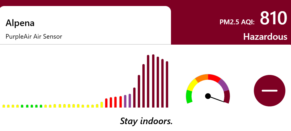
That's insane. I've been wondering how many houses in the upper mid-west don't have AC and can't hide in filtered air like most of us. Some places in upper MI were near 1200 at times and I bet less than half of homes have AC up there. I don't smell smoke yet, but the air is getting that hazy look
-
85/73 with no wind at all and the air is getting smoky. I feel bad for the guys building my neighbor's new deck out in this
-
OMG