

powderfreak
-
Posts
80,387 -
Joined
-
Last visited
Content Type
Profiles
Blogs
Forums
American Weather
Media Demo
Store
Gallery
Posts posted by powderfreak
-
-
1 hour ago, alex said:
Nice big fluffy flakes falling. How are things in Stowe? Headed there tonight
The suns out. Town is very busy with the double holiday week. Folks taking a week vacation before and a week vacation after Xmas. Stowe Area Association occupancy craters down again on Jan 2nd.
-
2 minutes ago, weatherwiz said:
wasn't there a local upslope event a few winters back...maybe 2017-2018? Parts of NE CT ended up with like 7-8'' and literally nothing was forecast (in terms of accumulations).
There was a pretty cool standing wave event… I definitely remember that. A taste of the Green Mtns when grass was showing in one place but 4 miles away 5-8” fell. I remember Coventry posters with pics. Tolland too right? It was it just downwind of the hills? Maybe those are two different ones.
-
NAM with a nice burst of snow for some of you on the 24th.


-
 3
3
-
-
2 minutes ago, CoastalWx said:
I welcome March before December. Typically easier for snow.
And if it’s not going to snow it’s usually nicer with long daylight, ha. Not much to dislike.
-
15 minutes ago, CoastalWx said:
You already gave up. You can’t comment.
He lit the Xmas tree on fire and is now thinking about putting it out. Hasn’t quite decided.

-
 9
9
-
-
8 minutes ago, mreaves said:


2015 tried pretty hard on Xmas Eve. It was like 60F at the picnic tables.
-
3 minutes ago, MJO812 said:
Congrats on the 18z gfs
That’s a bigger solution through the heart of New England.

-
1
-
 1
1
-
-
Just now, CoastalWx said:
Euro srfc temps are insane up there.
I just keep looping the Sierra QPF progs for next 10 days lol. Just straight incredible moisture stream. One low departs and another is right on its ass hitting the same spot 12 hours later.
-
1
-
-
1 minute ago, CoastalWx said:
So...Euro is near 90 in Dallas on Christmas. W.T.F.
It seems taboo but I have this weird fascination with spending one Christmas of my life in a hot, tropical place with palm trees. That’s not DFW but sort of reminded me with the temperatures. Just to see how that climo part of the world experiences Xmas. Air conditioning while opening packages must be a trip.
-
1 minute ago, CoastalWx said:
SSTs are furnacing. Still 48-49 in BOS harbor.
Curious, when do they hit those temps on the return side of the cycle… May?
-
8 hours ago, Froude said:
What I wouldn't do to be holed up in the Sierra this week. While we debate inches they're doing it in feet over there. For Kirkwood...
Good grief. I was like why are there two ranges? Oh yeah, 12 hour amounts. Yikes!
I know a couple former Mansfield Patrollers out there, one dude from Jeffersonville transferred to Kirkwood Patrol and the photos so far have been nuts… can’t imagine after this.
3-7” in 12 hours must feel like flurries in the middle of that.
-
2 minutes ago, MJO812 said:
Models shouldn't go past 200 hours , heck even 150 hours.
“I don’t have the self control to not look at them for as long as they go out, so they should stop at 150 hours.”
-
1
-
1
-
-
47 minutes ago, CoastalWx said:
Euro is interesting there too. Maybe a Gene special?
Phin sees warning criteria there on that run.
-
5 hours ago, J.Spin said:
For the Northern Greens, I’ve found that Bolton or Smugg’s can pick up more in a storm than Stowe if there’s a very west side-favored event, since they’re the resorts on the more western side of the spine around here.
For the MRV portion of the Central Greens, one typically doesn’t see MRG outpace Sugarbush in many events – they really both do sit on the same (eastern) side of the spine, pretty much lined up next to each other. With the extra 400’ of elevation, occasionally one sees a bit of snowfall preference in the reverse direction, but it’s probably more a function of snow measurement timing/methodology in many cases.
Yeah in the more blocked flow events the west side areas can pack more fluff in for sure. Personally I also think wind plays a big role as well as ratios… blocked flow can lead to more wind on the east slopes and there are many events where I think total QPF is the same but west slope spots are dead calm with larger flake growth and the east side is wind-packed smaller flakes. That leads to more inches west but the same snowpack water on both sides.
You could spread 1.0” QPF across the Green Mountain Spine and see snowfall vary from 10-20” just based on wind and flake size. Gusty winds, shattered dendrites and ground packing, vs Champagne Powder fluffing up nicely in a calm environment.
-
10 minutes ago, dryslot said:
For it to stay on the models the next couple cycles, You're probably in one of the better spots as long as it tracks where the GFS has it.
Phin might be near warning snows on that… might sneak into it on that prog. Tamarack and Kuligan.
-
0/-4… brrrr.
-
2
-
-
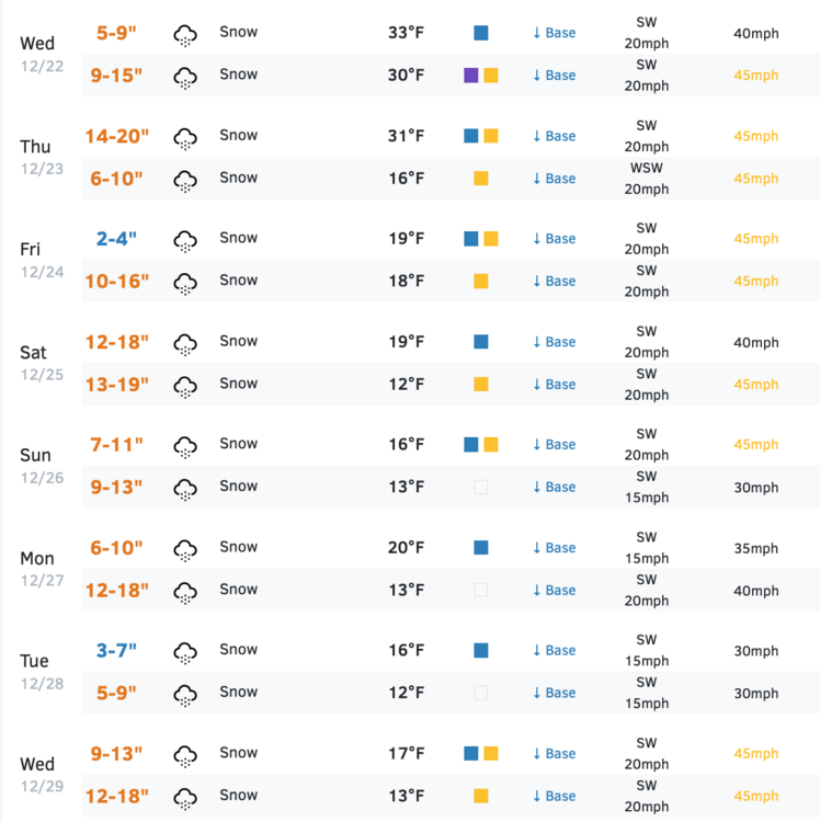
Saw this from Stowe Hollow which is actually away from the Spine, video showed steady snowfall still before sundown.
8.5” on ground is decent from this one about a mile away lol. I’ve only got 7” after an inch today.

-
BTV’s map of totals. AWT with basically 4-8” state wide and low ratios. Eastern slope in CVT with best on blocked SE flow.

-
 1
1
-
-
22 minutes ago, klw said:
Another 4 inches overnight. 10.3 total.
When I shoveled the back walk, it had more heft to it than I was expecting.
That’s awesome.
6” here. Lower Village guy had 5.5” on 0.65” water… which is an 8.4 to 1 ratio.
Right in line with the ratios expected. No upslope fluff.
Healthy QPF dump.
-
11 minutes ago, Damage In Tolland said:
congrats VT on the win. AWT
Lol that map isn’t even close.
About 6” here. Nice snowfall event with decent QPF. It’s winter again.
Looked very similar to NH and ME.
-
Backside snow moving through now. Looks so wintry outside again finally after the last week.

-
1 minute ago, dendrite said:
Looking decent out of ENX
Yeah you guys have that stuff building over by I-88 west of ALB… got some snow to go.
-
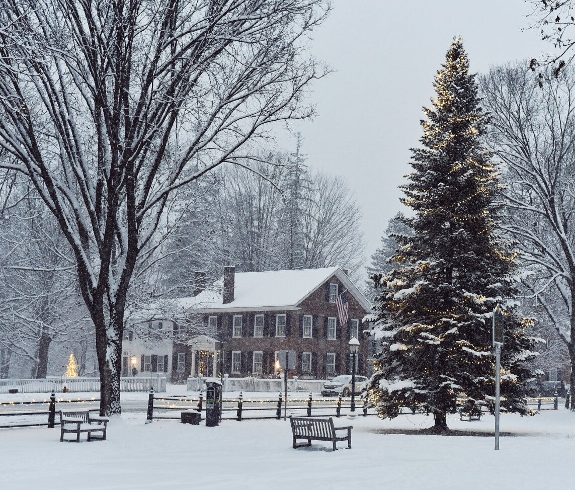
1 minute ago, snowfan said:
Still coming down. Trees looking saggy. Was so nice out earlier.

Awesome shot. The vibe changes quickly with a nice moderate snowfall this time of year.
-
2
-
-
Took the dog out for her evening walk and saw the snow depth stake showing 5” but after measuring on the elevated board it’s 4.3”. That’s the difference between measuring on grass vs flat firm surface, ha.
A good, dense synoptic snowfall that is inside the forecast range expected. Should be able to add 1-2” to that overnight as flow goes NW and likely be in a 0.50-0.60” water range?
Looks and feels much more like winter. Will ensure a White Christmas given the thicker synoptic density.
-
2
-


December 2021 Obs/Disco...Dreaming of a White-Weenie Xmas
in New England
Posted
Interesting on the GYX radar you can see what’s likely the snow line around Sunday River, right? Echoes go more smooth and lower reflectivity sort of on a Bartlett to Andover line. That higher reflectivity stuff must be mixed?
Then also the weird cellular almost convective looking stuff further north.