

powderfreak
-
Posts
80,387 -
Joined
-
Last visited
Content Type
Profiles
Blogs
Forums
American Weather
Media Demo
Store
Gallery
Posts posted by powderfreak
-
-
5 minutes ago, Damage In Tolland said:
In your professional opinion. VT or NH/ ME better overall on this one. Asking for a met
You keep asking this… what did I miss?
-
1 minute ago, OceanStWx said:
Drive home featured lots of needles with the odd solo dendrite. Makes sense when you consider that we didn’t hit -10 until 578 mb on the balloon.
No surprises. Playing out almost exactly as though. I think it’s called AWT? The ski trails need a good shot of QPF regardless of inches of snow, ha.
-
30 minutes ago, dendrite said:
3.5” new / 0.30” liquid
That seems about the same here… 3.5-4” eyeball but man it feels like more liquid than that. I was going to guess 0.40”+ QPF and under 10:1.
All small dense flakes but definitely water in there.
-
Good lord, what’s happening in here. Christmas trees getting lit on fire by some?
Snowing hard now. 2-3” very dense inches. Lots of QPF in this. Flake size just got much better. Bulk here was 6-10pm I think so should be getting into it.

-
 4
4
-
 3
3
-
 1
1
-
-
2 minutes ago, klw said:
3 inches as of 3pm
You’re on the east slope there in CVT right?
Models really like that blocked SE flow into the Greens.
18z NAM family:


-
Steady light snow and better flakes after an hour or so of tiny flakes.
-
1 hour ago, OceanStWx said:
I like the snow depth map better. But I've like 4-6 for most of my CWA for the last couple of days.
We are in agreement. 3-7” or 4-8” splitting hairs. Maybe a spot 8 or 9” Killington/Sugarbush at high elevation where they do SE blocked low level flow well. Ludlow/Okemo too.
-
7 hours ago, qg_omega said:
NAM /GFS? No more model talk in the storm thread?
Models haven’t changed in days it seems. Not much to talk about. If one came out congrats Montreal or congrats ORH, then it’s probably discussed.
I’d say if you see something worth mentioning, drop it in. We all know we are checking them out.
-
Cooled off real nice since yesterday.
High of 46F yesterday and sitting 28/17 now, wet-bulb in mid-20s.
Nice cold air drain.
-
3
-
-
Not much to add to the 18z EURO. Event has seemed locked in, I’m not sure I’ve seen as consistent a run of QPF progs as the past two days… every run is within a tenth or two of the previous runs for like 8-10 model cycles.
I still think it’s a bit over done but it’s just so consistent in the 0.5-0.75” range for a wide area every single run.

-
 1
1
-
-
Just now, moneypitmike said:
The fact that it took 3 hours to fill page 20 of this thread tells you all there is to know.
Yeah it must be about to snow in NNE lol.
-
4
-
4
-
 1
1
-
1
-
-
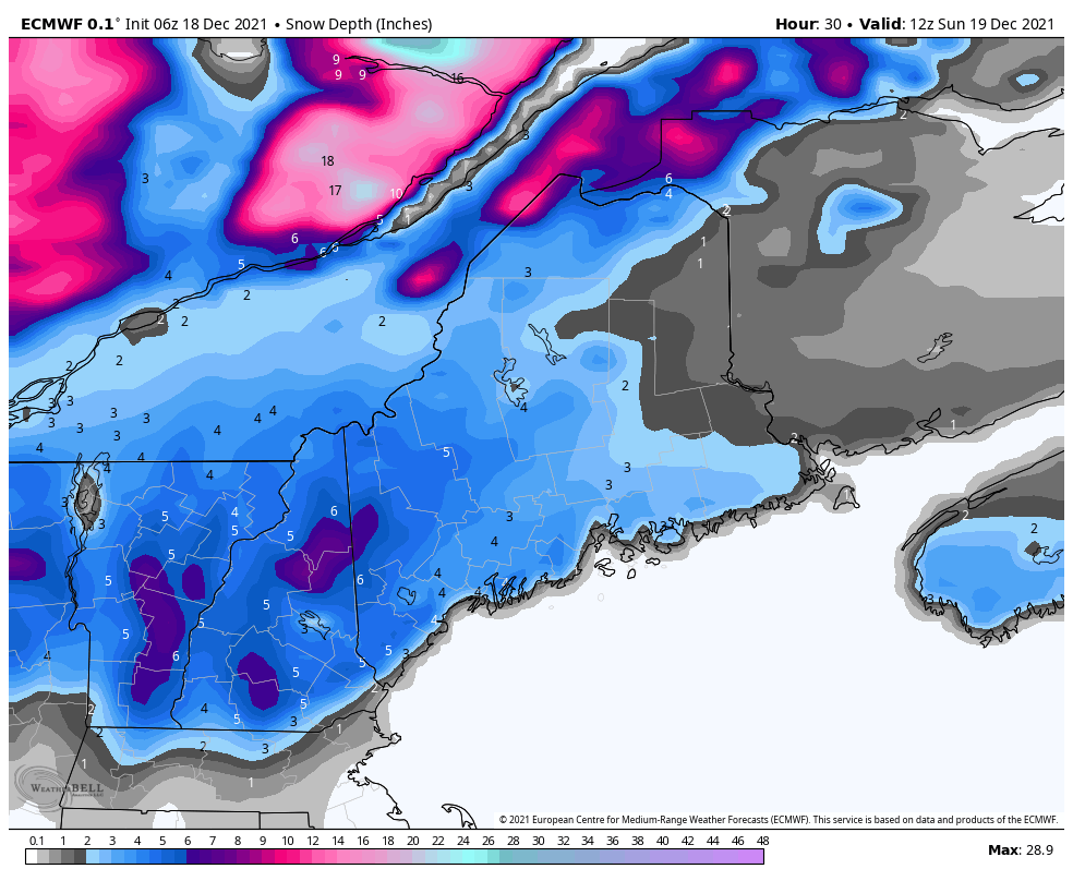
Still like a general 3-7” for NNE… liked that two days ago and still like it. Maybe a lolli to 8” somewhere near Dendrite? But overall it’s been or seemed to be a pretty easy forecast north of the mix line.
-
10 minutes ago, OceanStWx said:
I'd agree on the aggressive. We have only rain or snow in the forecast, which is why our totals are so high. The lowest ratio we have is about 6:1, but if it sleets it's going to be much lower than that (can probably halve your snow amount in that window).
Biggest red flag I'm seeing right now is that no matter where I click around for a sounding I'm seeing the DGZ around 500 mb. I prefer it around 700 mb because that's where lift tends to be maximized. When the DGZ is up at 500 mb it's a warm atmosphere and lift is poorer and ratios usually stink. I wouldn't be going with climo ratios with this one if it were my forecast.
That’s been my hold up… ratios. And getting widespread 6-8” will need a good 3/4ths inch QPF. Not sure if this has it in it. I like widespread 4-6” with maybe some spot 6-8”.
-
1
-
-
That 12z HRRR is juicy.

-
2
-
1
-
-
4 minutes ago, Greg said:
That map is a little aggressive from GYX but not surprising.
I feel like BTV and GYX went a little aggressive last night but it’ll be ratio dependent IMO. Splitting hairs as a bunch of 6.2” grids trigger 6-8” maps.
-
18 minutes ago, weatherwiz said:
18z GFS for Keene, NH but snow ratios fall more quickly than Urban Meyer

That’s why 8:1 is usually a good starting point for an event where the lift is largely due to mid level warming, unless it’s extreme cold in the antecedent air mass. Decent 700mb warm front lifts north ahead of the frontal wave… might start as ok ratios but we all know these events like needles and higher density flake types.
-
17 minutes ago, dendrite said:
It’d be funny if my avg high is lower than you this month with these days where I don’t mix out.
It's insane seeing the difference between those who mix out and those who don't when it's torching aloft. Like if that barrier breaks, it's off the races. If it doesn't, it's a whole other planet.
Feels like April with sunshine and warmth... reminds me of April when further southeast is locked in coastal mank at temps in the 40s while we are sunning on the Picnic Tables in t-shirts.
-
2 minutes ago, CoastalWx said:
There could be a mini Jack near the coastal front. It’s possible you get shit flakes just west of the front along with the sleet.
Yeah I don't know the climo down there as much, but the whole set-up just seems to be lower ratio snow when it's warming in the mid-levels and not overly cold to begin with. The QPF seems juiced but the dynamics don't seem to match those progs. I don't know, something about this system doesn't scream "take the over." Sort of like the 10:1 snow map 6" area really is the 4" area.
-
33 minutes ago, ORH_wxman said:
18z euro ticked warmer. Took CT out of the advisory snows except maybe far N CT.
I actually think it makes sense that the higher snowfall zone becomes more acute/shrinks and we see a more narrow zone as this gets zeroed in on (as compared to the ensembles which show a larger geographic area of heavier snowfall). I still think ratios will not be as high as 10:1 in the higher QPF snow zones... even up north. I like 8:1 flakes in these mid-level WAA events, taking everything down a notch from the snow maps.
3-7" is my call for CNE/NNE posters above RT 2. I guess localized areas could see a spot 8" amount in SVT/SNH. Tossing any 10" amounts. I like Dendrite's location.

-
3 minutes ago, jculligan said:
Incredible temperature ranges over very short distances this evening. This is the most extreme example I can find in New Hampshire:

At my location, we had slipped back to 36F but have since spiked back to 44F which is now the high for the day.
30s to 60s in such a short distance is incredible. What a map there. That's a saver.
-
Mansfield summit sitting 47F currently. Stake depth didn't take too much of a hit today though. Sitting at 16" depth.
The only thing missing from an April vibe is the lack of daylight.
-
I saw something flying in the flood light off my porch this evening... moth? Rare to see any insect flying around in mid-December here.
Today was like April climo. We started cooling off a little but then mixed out again and spiked into the upper 50s this evening. Pretty damn crazy. Shades of Dec 2015.
CLR skis all afternoon with mild temperatures, it was unbelievable. Such a nice day skiing. Soft snow, mild temperatures, everyone having a great time. Folks really do love sunny mild weather for skiing. Check out the MVL obs... mild, then cooling off, then spiking high as it mixes again with a 14F increase from 4-6pm.

Glorious hero turns in the soft snow though. Like I said, felt like April but with much less snowpack. We do enjoy these days though if Mother Nature is going to torch.

-
2 hours ago, CoastalWx said:
58 for the high here. Might mow again. Birds chirping in the air and forsythia blooming. I'm not kidding.

I saw something flying in the flood light off my porch this evening... moth? Rare to see any insect flying around in mid-December here.
Today was like April climo. We started cooling off a little but then mixed out again and spiked into the upper 50s this evening. Pretty damn crazy. Shades of Dec 2015.
CLR skis all afternoon with mild temperatures, it was unbelievable. Such a nice day skiing. Soft snow, mild temperatures, everyone having a great time. Folks really do love sunny mild weather for skiing. Check out the MVL obs... mild, then cooling off, then spiking high as it mixes again with a 14F increase from 4-6pm.
Glorious hero turns in the soft snow though. Like I said, felt like April but with much less snowpack. We do enjoy these days though if Mother Nature is going to torch.
-
54 minutes ago, greenmtnwx said:
They must be going with a more northerly solution
It’s weird because I also see this map, made same time as the other one. Shows a bit more 6”+ in spots down south too.

-
1
-


Overunning Mixed Event 12/18-12/19/21
in New England
Posted
Something just changed… snow growth got big. First real flakes.