

powderfreak
-
Posts
80,387 -
Joined
-
Last visited
Content Type
Profiles
Blogs
Forums
American Weather
Media Demo
Store
Gallery
Posts posted by powderfreak
-
-
1 minute ago, dryslot said:
He should be punished, I bet he still found some meh in that run.
You look good on that run. I like being where the QPF gradient is, that's often where mid-level banding finds itself for whatever reason. That QPF map leads one to envision a band paralleling the Maine coastline somewhere on the Plain, and then curling into SNE. Good slug of precip to it's east and a sharper than modeled drop off to its west.
-
 3
3
-
-
9 minutes ago, Baroclinic Zone said:
Does that exclude anything that just fell over the last 6hr here? Just had 0.66" fall in the last few hours.
Ah shit you’re right. Didn’t realize it was raining down there. My bad for sure. I’ll delete other post. Here’s the snow storm.

-
2
-
 1
1
-
 1
1
-
-
7 minutes ago, ORH_wxman said:
Yeah when you look at soundings, there’s a fairly deep area of lift and it goes into the SGZ…even the ugly solutions have that weenie band early in the storm…I think worst case scenario is prob 2-3” of blower fluff there. But there’s def some upside for higher amounts.
It's pretty cool that you can see a weenie band in the 18z EURO QPF progs. Looks like a finger of mid level fronto that develops on the front side and as the low passes that longitude.
H7 wind flow goes pretty much calm over the zone, which seems weird and maybe I'm not visualizing it correctly. I'd think there'd be more convergence vs divergence in the wind barbs.


-
1
-
-
21 minutes ago, ORH_wxman said:
Deeper into interior is a tougher call. I do think at least advisory snows are likely due to the weenie banding early in the event…but I’m not sure about later on. My gut is this ticks closer in near the vort and everyone ends up getting more than currently shown, but we’ll see. It’s a hard forecast…if I was forecasting for my old clients in ORH county and Union CT then I’d prob be saying 3-5” but telling them to look for updates as there is more uncertainty than usual with higher amounts possible.
I was thinking 2-5" for Woodstock area, so that fits. I think there's a low prob of 2" unless snow growth somehow is putrid and would lean more towards 12:1 and 4-5". Mid-level banding is always the wild card west of the best QPF.
-
4 minutes ago, dendrite said:
Can anyone else confirm this? I find this many strikes near the pole hard to believe.
https://www.cnn.com/2022/01/05/world/lightning-increased-north-pole-arctic-2021-climate/index.html
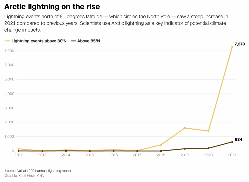
Sensor malfunction? I honestly have no idea how those lightning sensors work to begin with. We watch them a lot at the ski resort in the summer and they do seem to like phantom strikes sometimes. “Like well that one looks on top of us but no one heard or saw anything.” Then again they are correct a lot of the time.
-
1 hour ago, CoastalWx said:
We 50s. Luckily no pack so bring the mild weather.
50s and then a snowstorm? Sign me up.
High of 32F here today.
-
1 hour ago, Ginx snewx said:
Congrats NH DOT 1 hr after everyone knew about all the accidents in NY NYC Ct
That sh*ts wild… the stopped vehicles just slowly following gravity.
-
2
-
-
2 minutes ago, CoastalWx said:
Could see a weenie fronto band well NW before the initial surge of precip.
Early look 18z HRRR went wild on the south shore. Good banding from Long Island to Ginxy to you on the simulated radar.

-
10 minutes ago, Hitman said:
Yeah, well, more power to him, but I ain’t going anywhere near that wall of death. Yikes.
Haha I hear ya. I’d stand under it but wouldn’t jump on it from above
 .
.
-
3 minutes ago, TauntonBlizzard2013 said:
Snow maps FTL… unless you get under a good band, that’s a pretty light snowfall
You think ratios will suck?
-
2 minutes ago, TauntonBlizzard2013 said:
Euro is a general 1-3, 2-4….. mainly 1-2” for most
How do you look at that snow map and arrive at mainly 1-2”? That’s like DIT seeing it and saying 5-10”.
-
 4
4
-
-
Just now, mahk_webstah said:
That finishes it for many of us.
Until 18z.
-
2
-
-
52 minutes ago, Hitman said:
I'd be too scared to stand where that guy is.
The irony is that’s probably the safest place on the slope now that the hill’s energy has been released. There’s nothing trying to pull that top part down anymore, like the slope’s rubber band snapped and there’s zero tension.
-
These western avalanches have been insane. Here's one from the Wasatch in Utah. Death is certain if you get caught in anything remotely close to this size.

-
3
-
-
Still looks like high POPS for snow across SNE.
-
12 minutes ago, PhineasC said:
Oh yeah, I don't trust it, but sometimes it sniffs out some amped solutions like the NAM does from time to time.
You would've loved the SREFs and the ARW family back in the day up here.
-
1
-
-
I kind of like the 18z EURO Kuchie map for some reason.
A widespread 3-6" with locally 6-8" is just what this forum needs. It'll be interesting to see the snow growth potential the next couple of days. Ratios always matter... small flake vs deform dendrites. Kuchie runs fluffy when its cold.

-
12 minutes ago, dendrite said:
It's a long time for here. I usually get at least 1 single digit high every winter, but I've had none going back to Jan 19. I had 7 of them in those couple of weeks in late Dec 17 into early 18.
We almost got one yesterday with 24-hr max of 11F. It’s crazy how cold the last two days have felt despite it being fairly routine January fare. Body gets used to endless highs in the 30s.
-
3 minutes ago, eduggs said:
1. Smaller events are usually shorter events and that means you might not be able to enjoy them due to work or sleep.
2. In places that don't get snow events very often, there can be a feeling like you have to cash in on every chance that you get because you can't count or another to look forward to.
Good points, that feeling of needing to maximize every chance. I also see some views that if I had to commute into Boston with traffic, that 3” may not be worth an extra hour long sh*t show in a car to get home or whatever.
Anyway, I often draw the line at 3” as that’s the amount that often makes a visual difference that “it snowed.”
-
1
-
-
1 hour ago, HIPPYVALLEY said:
It’s just been tough because we’ve had a total of 4” since Nov 1st, spread over multiple events, there’s no ice on the ponds and Berkshire East has about 4 trails open.
I’m sure it can get better in a hurry but it’s been a tough start.You’ve had 4” total this winter? Wow I definitely thought it was a bit better down in the RT 2 area. Still knew it was bad but that’s worth b*tching about.
-
1
-
-
1 hour ago, CoastalWx said:
Soundings looked nice. I’ll take a 3-6” snow and run. Or any snow for that matter.
I don’t get the forum aversion to a 3-6” snowfall. Sure, it’s not a big bomb or as exciting, but 3” or more is where a landscape goes from perpetual autumn to “hey it’s winter.”
This winter 3-6” is a big deal too.
-
2
-
-
2 minutes ago, dendrite said:
jspin is going to pull 15" off of 0.05" in the upslope.
No bamboo damage there.
-
1
-
1
-
-
5 minutes ago, dryslot said:
I'm shocked, I'm speaking to terms up here, To PF's comment, Not for SNE.
I mean you did say "I like when it tracks...." We all know there are different tracks/angles for different locations.
-
Up to 14F at MVL after a min of -8F.
It's cold outside. This is mid-winter flavor cold the past two days.


Tracking Jan 7 coastal storm. Lingering compression/flow velocity has not lent to consensus, but it seems at 30 hours out.. finally?
in New England
Posted
1-3". Some upslope snow showers. Still snow on the trees has kept it wintry, high of 32F today helped. Much better than the single digits and below zero cold of recent days. We rely on some weak moisture and NW flow for this system on the backside. Ratios likely help as it's cold aloft. Maybe J.Spin and favored calm fluffer locations pull 4"?