

powderfreak
-
Posts
80,387 -
Joined
-
Last visited
Content Type
Profiles
Blogs
Forums
American Weather
Media Demo
Store
Gallery
Posts posted by powderfreak
-
-
Just now, TauntonBlizzard2013 said:
Yes… it’s a pretty hefty thump for everyone off the cape
Yeah the different grid sizes are worlds apart in terms of solutions, ha. That 3km was a nice thump to ice, ending as some rain for a good chunk of posters. Would likely end with white ground for many.
-
 1
1
-
-
1 minute ago, ORH_wxman said:
3km NAM was actually decently colder than the 12km on the 18z run.
Yeah I realize that’s what TauntBlizz must’ve been talking about.
-
4 minutes ago, TauntonBlizzard2013 said:
18z NAM doesn’t look much different… maybe a little beefier on snow totals across a wider area?
18z NAM:

Edit: you must mean the 3km one, my bad.
-
 1
1
-
-
At least no one is getting kicked with a “glad we don’t live there” when they are down.
-
 3
3
-
-
3 hours ago, Damage In Tolland said:
If what they’re saying on here about continued warming of models, this could end up all rain into SNH. Not just ORH south
6 minutes ago, Damage In Tolland said:How much snow is left at the condo now after the screamer ?
Zero. Zero before, zero after lol.
Folks are just busting your balls dude. You already tried it this morning by wondering if this rains straight up into New Hampshire once someone said something about south of the Pike.
-
1
-
-
3 minutes ago, Damage In Tolland said:
I’m not sure when I’ve ever rooted for other people to get plain rain while I get snow like this will turn out being But I will certainly be sure to remember this .
But when your snow melts you try to melt everyone else’s?
")
-
 1
1
-
-
That was a real nice Euro run at 6z… juicy.

-
1
-
-
Where is @PhineasC? Snow chances coming up. He's not around. If it's because he told Forky to get bent, yikes.
-
 2
2
-
-
1 minute ago, dryslot said:
Just looked at soundings, Something going on with the clown algorithm here, That was like 0.9"qpf and we were isotherm from the layers i could see.
Yeah usually by the time you get into NH/ME in that set up it’s pretty universal snowfall… not a lot of variation. Very little mesoscale variation with a slug of warm air advection.
-
11 minutes ago, CoastalWx said:
Maybe the GFS will be right after all. LOL.
Goal posts narrowing. RT 2 north with the classic SWFE area of southern Greens to Center Harbor to all of western Maine from Rangley to Tamarack to Dryslot. Don't care what the snow map says, Dryslot snows more than that shows. It's got the feel of a large area of 3-6", with 4-8" for the climo swath... sharp gradient on the south side but 1-4" with sleet then rain.
The trick is finding out where the gradient is but the overall vibe seems to be of narrowing goal posts towards SWFE climo.

-
1
-
-
12 minutes ago, CoastalWx said:
87kts at KRSL. Russell Kansas. That’s not from convection. WTF.
How do you get synoptic 87 knots? I can’t process that.
-
4 minutes ago, CoastalWx said:
New England weather is boring AF. Give me a break with the “harsh” New England weather nonsense. We have no severe, no canes, and ok some snow. Big deal compared to what these other places get. I know there is the one in 20 year cane and some nor’easters......but we have it easy when you think of it.
We were talking about that the other day in the office... how ice storms and occasional high wind or flash flooding is a "threat" here... but no matter what, those who experience TOR threats on the regular are on a whole other level. Tornadoes, high-end severe storms, and hurricanes are the apex predators of the weather world.
-
1
-
-
18z GEFS did tick south... it keeps increasing that RT 2 area in MA the past couple runs.
It is world's different than some other guidance though in terms of the warm air advection and precipitation amounts across the north country.

-
1
-
-
6 minutes ago, jculligan said:
Yes, I'm feeling cautiously optimistic about finally scoring my first 6"+ event of the season with this one. Two weeks later than last year, but unlike last year...it looks fairly likely we'll keep whatever we get through Christmas.
Yeah I’m just looking for 3”+ as usual, ha. Cover the grass, plowable… 3” is usually my number to hit to be considered “an event.” I do think 3-6” seems like a starting range here, in line with ensemble means.
-
30 minutes ago, DavisStraight said:
Nothing better than being with a beautiful lady while its S+ outside, best of both worlds.
Like walking back home in college at UVM in Burlington at 2am while it’s dumping with a girl….
”You seem cheery, you excited I invited you back to my place for the night?”
“Sure, but I’m also stoked the flow is blocked and the snow has backed up into the Champlain Valley…”
-
1
-
6
-
 1
1
-
-
1 minute ago, greenmtnwx said:
Will, What are your thoughts on the southern Greens for the weekend, Stratton/Mount Snow?
A good place to be. I feel like these like to be SVT-Dendy-Dryslot style events for a jackpot zone. Merely climo-wise.
-
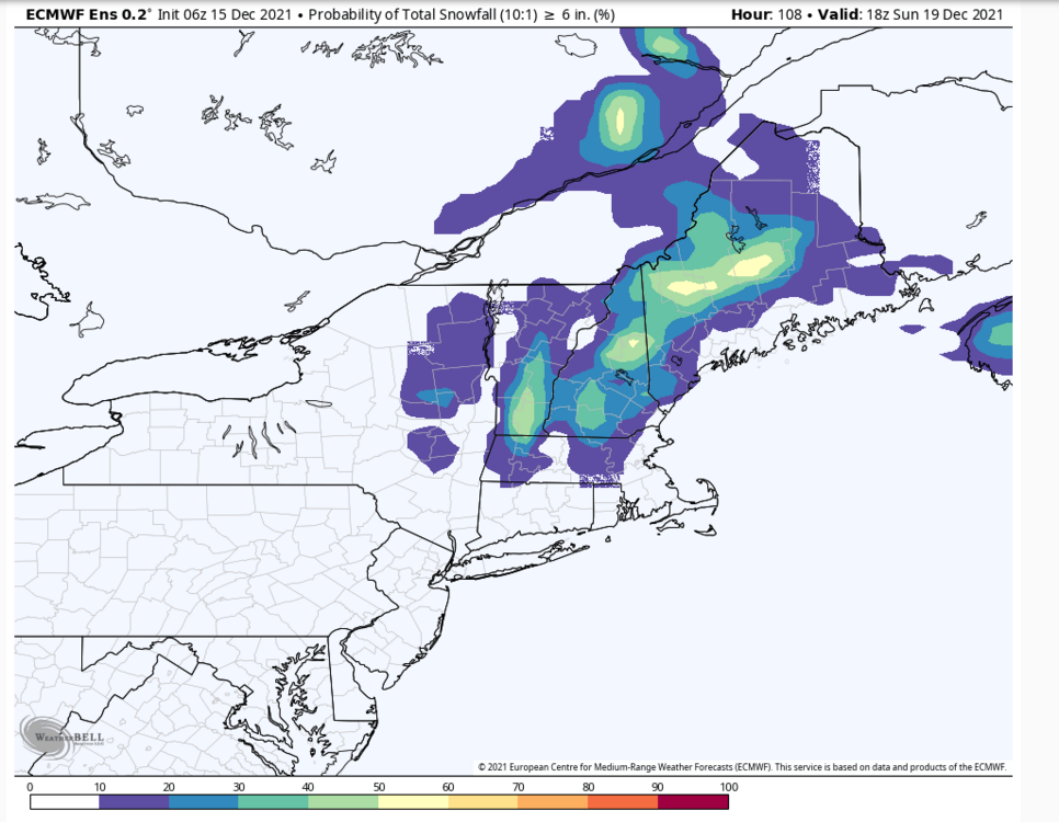
2 hours ago, jculligan said:
6"+ snowfall probabilities on the Euro ensembles in the 24-hour period from 18z Saturday to 18z Sunday:
This type of SWFE is right in your wheelhouse there climo-wise. SE low level flow under SW flow aloft.
-
1 minute ago, CoastalWx said:
East of the river, south of the pike, in and up.
As someone often on the edge of synoptic systems, I feel like an expert that can speak on plenty of systems where east/west is the discussion
 . Meanwhile folks in ORH don’t know what worrying about ticks east/west/north/south are like.
-
3
-
-
10 minutes ago, Baroclinic Zone said:
Love how it's always north or south on models and never east or west
Well SWFE vs coastal storm will be different. Plenty of conversations about east or west depending on the system.
-
Need some of that Sierra snow...
Mammoth Lakes down at town/lake level.

Palisades Tahoe... 5 feet storm total after the last round brought another 24" in like 12 hours.


-
7
-
-
2 minutes ago, rimetree said:
GFS is a decent hit here. Seems like that mainly snow line could be wobbling 10-20 miles north or south of the MA-NH border on models up until go time.
White Christmas for at least half of New England on that run.

-
1
-
-
17 minutes ago, DavisStraight said:
I thought you had a few inches on the ground.
The mountains have cover as the trails show, even at 1500ft where I usually spend all daylight hours, ha. We bare down low though.
But it’s a very sharp gradient and it has been mild as expected this week. We’ve had ground cover a lot of the time even if just a couple inches, several snowy evenings. But as we all expected, this week has been mild afternoons with warm 850s. Nights get crisp.
This well above normal period has been well advertised.
This was the December 11 - 18 (7-day) Euro ENS 850mb anomaly from a week ago on the 7th. Luckily we all knew this week was coming. Advertised and delivered.

-
1
-
-
5 minutes ago, greenmtnwx said:
All-time ratter potential here if some things don’t break right.
That seems premature. It can change in a hurry, but then again that’s breaking right. Maybe it snows 100” in February.
Its crisp outside now. 19F at local home PWS and 19F at the summit. I see some 15s northeast of here. Good for snowmaking. The cutters do hurt the appeal though when the ground cover has been light so far.
-
Dear Santa,
Please bring snow.
-Your friends in NNE
It has felt like we've been a few weeks behind climo all fall/early winter.
Walked the dog with a hoodie this afternoon. Had the vibe of mid-November.

-
2
-


Overunning Mixed Event 12/18-12/19/21
in New England
Posted
It’s a pretty damn BS reason he’s not posting. I need a northern cohort to balance the force.