ChescoWx
-
Posts
7,453 -
Joined
-
Last visited
Content Type
Profiles
Blogs
Forums
American Weather
Media Demo
Store
Gallery
Everything posted by ChescoWx
-

E PA/NJ/DE Spring 2024 OBS/Discussion
ChescoWx replied to Hurricane Agnes's topic in Philadelphia Region
So how does the last several months rank among the all-time wettest out here in Chesco? For the December thru February months this season ranked as the 3rd wettest the top 5 being: 1978-79 = 21.37" / 1901-2 = 19.80" / 2023-24 = 18.83" / 1898-99 = 18.24" / 1909-10 = 18.18" For the 4 month period December thru March this season ranked 2nd with the top 5 wettest being: 1898-99 = 25.90" / 2023-24 = 24.97" / 1993-94 = 24.86" / 1901-02 = 24.80" / 1978-79 = 22.88" -
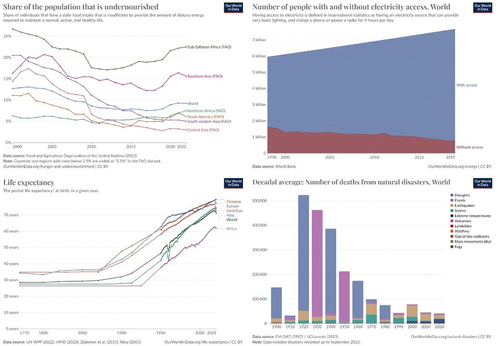
Don where is the problem again?? Life expectancy up....undernourished population down....deaths from natural disasters - down. How can all of this be happening in the world of climate alarmism? Where again is the crisis???
-
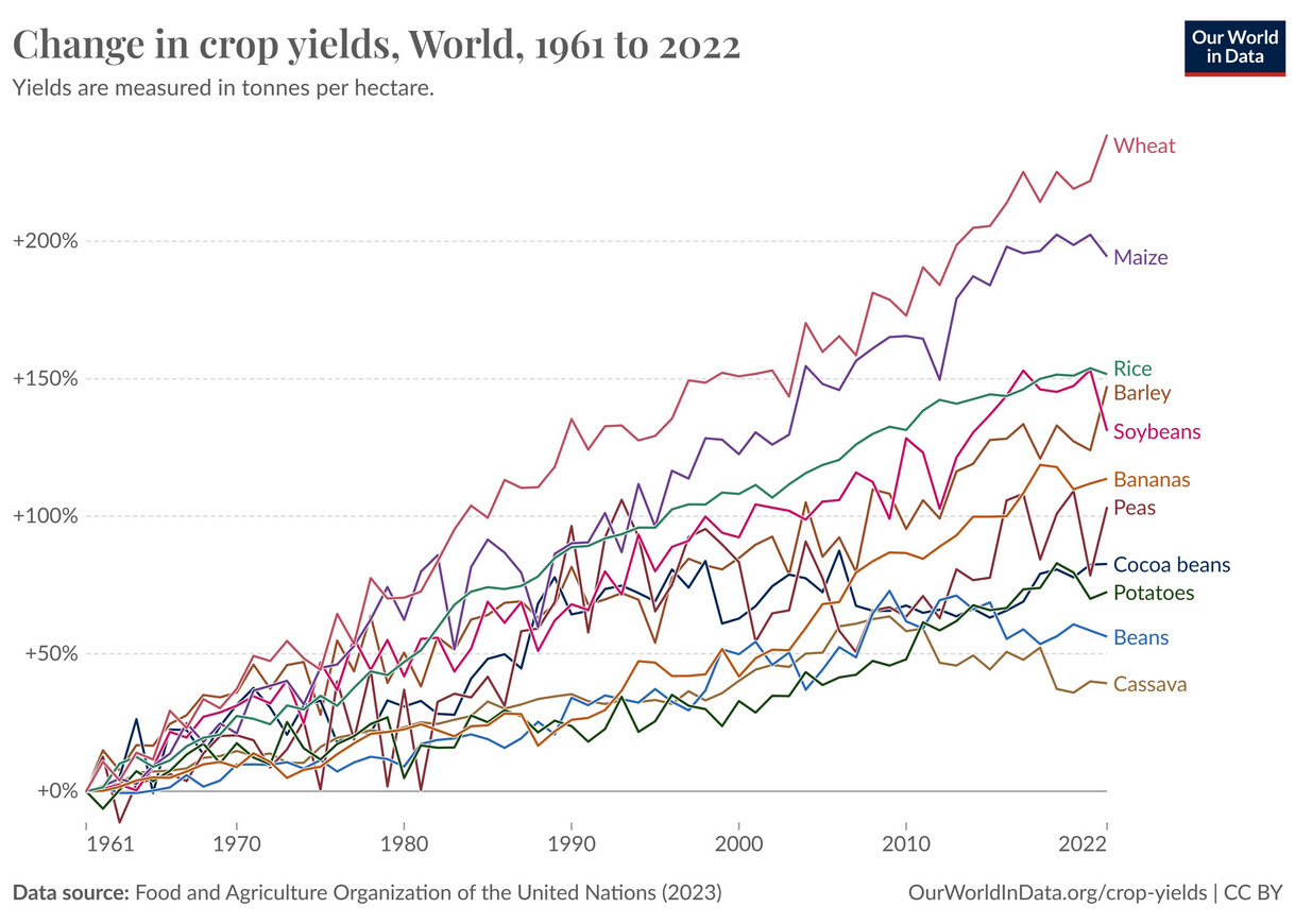
Looks like our current cyclical climate change is really hurting the world's crop production....
-
Don please provide some actual dates and events that have never happened before that are the result of climate change? Those places ravaged by fires and floods have of course been ravaged by fires and floods in the past. There is zero factual evidence....
-
Love the typical alarmist talking points - as usual Charlie shows us no facts like dates and storms that are attributable to climate change in this alarmist answer. Just the tired old bullet points that are alarmist talking points with not one shred of evidence.... you know like an actual date, storm, observation or fact. I will wait for you to list events that anyone can directly attribute to our current period of cyclical warming.
-
With the 0.11" that fell here in East Nantmeal since midnight we are now up to 4.01" of rain since the month began on Monday. Some other area totals so far: Atglen 3.71" / Chester Springs 4.05" / Devault 3.76"/ Glenmoore 4.10" / Kennett Square 4.66" / Longwood Gardens 4.11" / West Bradford 4.67" / Nottingham 3.61"/ West Chester 4.51" / West Grove 3.69" / Warwick Twp. 3.99". Should finally see some sun today and tomorrow but still a chance of some showers and maybe some thunder w/ hail mixed in especially later this PM. Our below normal temps look to continue through the weekend before we finally see some milder weather by next week.
-
E PA/NJ/DE Spring 2024 OBS/Discussion
ChescoWx replied to Hurricane Agnes's topic in Philadelphia Region
With the 0.11" that fell here in East Nantmeal since midnight we are now up to 4.01" of rain since the month began on Monday. Some other area totals so far: Atglen 3.71" / Chester Springs 4.05" / Devault 3.76"/ Glenmoore 4.10" / Kennett Square 4.66" / Longwood Gardens 4.11" / West Bradford 4.67" / Nottingham 3.61"/ West Chester 4.51" / West Grove 3.69" / Warwick Twp. 3.99". Should finally see some sun today and tomorrow but still a chance of some showers and maybe some thunder w/ hail mixed in especially later this PM. Our below normal temps look to continue through the weekend before we finally see some milder weather by next week.
-
So are we sure that climate change is bad or a problem? Or is it simply the cyclical nature of our climate. What exactly is our correct appropriate temperature or even range of temperatures? How much do you think we warm by the new climate regime in 2040? Can you or anyone identify even one catastrophic climate event in the world that has happened in the last 30 years due to our current cyclical warming cycle? Any one will do. Of course it must have never happened before. All weather events that we can measure to date have all happened before....what weather event has recently happened (last 50 years) that actually never took place before? Can you point to a solid real world actual event that you or anyone can attribute to man made climate change?
-
The earth long ago perfected the CO2 experiment and it has been around for a very long time. The actual geological record has proven negative feedbacks exist in nature. If negative feedbacks did not exist, we never would have survived. The only thing unusual about the CO2 concentration we have in the atmosphere is how little of it there is today!!
-
As always with alarmists like AdMc....just call him a name and cancel opposing views....swell!!
-
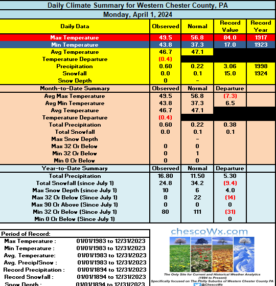
The rain just keeps on keeping on! Rain totals across Chester County over the first 3 days of the month of April: East Nantmeal 2.68" / Atglen 2.63" / Chester Springs 2.45" / Glenmoore 2.63" / Nottingham 2.39" / Warwick Township 2.57" / Devault 2.27" / Kennett Square 2.85" / Longwood Gardens 2.49" / West Chester 2.91" / West Grove 2.47" / Marshallton 2.90"
-
E PA/NJ/DE Spring 2024 OBS/Discussion
ChescoWx replied to Hurricane Agnes's topic in Philadelphia Region
The rain just keeps on keeping on! Rain totals across Chester County over the first 3 days of the month of April: East Nantmeal 2.68" / Atglen 2.63" / Chester Springs 2.45" / Glenmoore 2.63" / Nottingham 2.39" / Warwick Township 2.57" / Devault 2.27" / Kennett Square 2.85" / Longwood Gardens 2.49" / West Chester 2.91" / West Grove 2.47" / Marshallton 2.90" -
OHN CLAUSER, 2022 PHYSICS NOBEL PRIZE WINNER: "I can very confidently assert, there is NO climate emergency." “As much as it may upset many people, my message is the planet is NOT in peril. … atmospheric CO2 and methane have negligible effect on the climate. The policies government have been implementing are total unnecessary and should be eliminated. So far, [we] have totally misidentified what is the dominant process in controlling the climate, and all of the various models are based on incomplete and incorrect physics. The dominant process, is “the cloud-sunlight-reflexivity thermostat mechanism. Clouds are all bright white, and they reflected 90% of the sunlight back into space making them the most crucial yet most overlooked aspect of the climate system. Two-thirds of the Earth are ocean. The Pacific Ocean alone is half the Earth. The average cloud cover for the Earth is 67%; about 50% over land and 75% over oceans. I claim that the above conspicuous properties of clouds are the missing part of the puzzle.
-
The climate alarmists will tell you this lacks scientific merit even though many scientist supported these facts. They will tell you this is "settled" science....the truth is science is never settled and we do NOT have anywhere close to consensus. While AGW is of course real it certainly does not mean that AGW is a crisis or we are in any sort of "climate emergency". These two things can both be true. Do alarmist ever show empirical evidence to prove to us that extreme weather is worse now than it was 50 years ago? 200 yrs ago?? They will say well “experts say” or “science says.” or our model says....we want to see actual real world unadjusted climate data - where is the emergency? Oh and what exactly is the correct temperature of earth??

-
Here in Chester County PA this March was the 19th warmest average temp on record. . Four of the top 5 warmest March months were all before 1950 in rank order 51.7 (1945) / 51.4 (1921) / 50.0 (2012) / 49.1 (1946) / 48.1 (1903). Of note look how the National Center of Environmental Information (NCEI) chilled the average temperatures pre-1950 with post hoc cooling adjustments to mute the warmth we saw in those decades. 1945 Actual 51.7 - adjusted 49.6 / 1921 Actual 51.4 - adjusted 49.7 / 1946 actual 49.1 - adjusted 47.3 and 1903 actual 48.1 after adjustment 46.8. Interestingly not one available individual reporting station reported a number as low as these post hoc averages in any of these months.
-
E PA/NJ/DE Spring 2024 OBS/Discussion
ChescoWx replied to Hurricane Agnes's topic in Philadelphia Region
Here in Chester County PA this March was the 19th warmest average temp on record. . Four of the top 5 warmest March months were all before 1950 in rank order 51.7 (1945) / 51.4 (1921) / 50.0 (2012) / 49.1 (1946) / 48.1 (1903). Of note look how the National Center of Environmental Information (NCEI) chilled the average temperatures pre-1950 with post hoc cooling adjustments to mute the warmth we saw in those decades. 1945 Actual 51.7 - adjusted 49.6 / 1921 Actual 51.4 - adjusted 49.7 / 1946 actual 49.1 - adjusted 47.3 and 1903 actual 48.1 after adjustment 46.8. Interestingly not one available individual reporting station reported a number as low as these post hoc averages in any of these months. -
1.33" of rain so far since yesterday here in East Nantmeal with 0.73" falling since midnight. Our wet and chilly start to April continues through Thursday. Records for today across the county: High 86 degrees Coatesville (1967) / Low 16 degrees Phoenixville (1964) / Rain 3.48" Phoenixville (2005) / Snow 5.0" Devault (1965)
-
E PA/NJ/DE Spring 2024 OBS/Discussion
ChescoWx replied to Hurricane Agnes's topic in Philadelphia Region
1.33" of rain so far since yesterday here in East Nantmeal with 0.73" falling since midnight. Our wet and chilly start to April continues through Thursday. Records for today across the county: High 86 degrees Coatesville (1967) / Low 16 degrees Phoenixville (1964) / Rain 3.48" Phoenixville (2005) / Snow 5.0" Devault (1965)
-
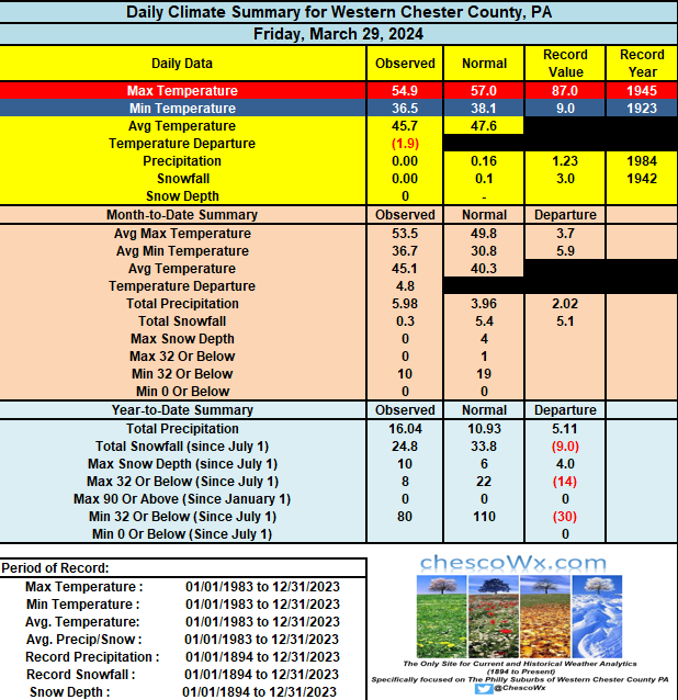
10 of the last 12 days have featured below normal temperatures....today and tomorrow will be close to normal before more below normal weather arrives to begin the month of April. After some sun today and shower chances this evening it should be a beautiful Easter Day tomorrow before a very rainy week sets in starting Monday till Thursday AM. We could see almost 3 inches of rain across parts of the area. Records for today: High temp 88 Coatesville (1998) / Low 12 Phoenixville (1921) 1.93" West Chester (2001) / Snow 4.5" West Grove (1942)
-
E PA/NJ/DE Spring 2024 OBS/Discussion
ChescoWx replied to Hurricane Agnes's topic in Philadelphia Region
10 of the last 12 days have featured below normal temperatures....today and tomorrow will be close to normal before more below normal weather arrives to begin the month of April. After some sun today and shower chances this evening it should be a beautiful Easter Day tomorrow before a very rainy week sets in starting Monday till Thursday AM. We could see almost 3 inches of rain across parts of the area. Records for today: High temp 88 Coatesville (1998) / Low 12 Phoenixville (1921) 1.93" West Chester (2001) / Snow 4.5" West Grove (1942)
-
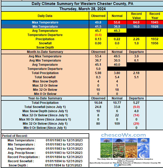
Happy Phillies Opening Day to all who of course should celebrate! Looks sunny but a bit chilly for the opener with gusty winds and temps in the mid 50's in philly and low 50's out here in Chesco. Milder by Sunday with temps well into the 50's in the county and in the lower 60's in philly. Some showers are possible again late tomorrow before a sunny Sunday. Another wet week looks likely starting Sunday night through Wednesday. With temps struggling to escape the 40's for much of the time it is raining. Records for today: High 88 Phoenixville (1945) / Low 9 above Coatesville (1923) / Rain 1.87" West Chester (2005) / Snow 3.0" Coatesville (1942)
-
E PA/NJ/DE Spring 2024 OBS/Discussion
ChescoWx replied to Hurricane Agnes's topic in Philadelphia Region
Happy Phillies Opening Day to all who of course should celebrate! Looks sunny but a bit chilly for the opener with gusty winds and temps in the mid 50's in philly and low 50's out here in Chesco. Milder by Sunday with temps well into the 50's in the county and in the lower 60's in philly. Some showers are possible again late tomorrow before a sunny Sunday. Another wet week looks likely starting Sunday night through Wednesday. With temps struggling to escape the 40's for much of the time it is raining. Records for today: High 88 Phoenixville (1945) / Low 9 above Coatesville (1923) / Rain 1.87" West Chester (2005) / Snow 3.0" Coatesville (1942)
-
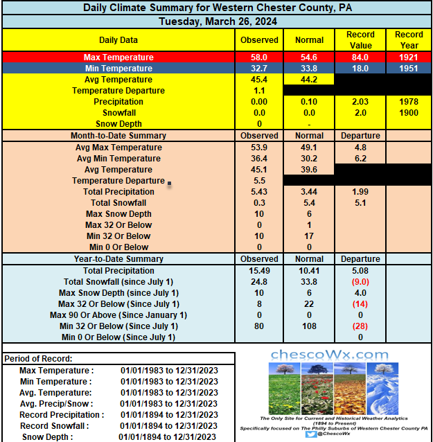
Cloudy day with showers arriving shortly. Chilly with temps remaining in the 40's in most locales. Steadier rain by later today and through tomorrow morning. For those who celebrate Opening Day of the baseball season (should be a national holiday IMHO) the Phightin Phillies game may be in a bit of trouble....Friday looks much better but breezy and chilly, Record High 85 degrees in Coatesville (1921) / Low 16 West Chester (2001) / Rain 2.54" Chadds Ford (1978) / Snow 2.0" Devault (1959)
-
E PA/NJ/DE Spring 2024 OBS/Discussion
ChescoWx replied to Hurricane Agnes's topic in Philadelphia Region
Cloudy day with showers arriving shortly. Chilly with temps remaining in the 40's in most locales. Steadier rain by later today and through tomorrow morning. For those who celebrate Opening Day of the baseball season (should be a national holiday IMHO) the Phightin Phillies game may be in a bit of trouble....Friday looks much better but breezy and chilly, Record High 85 degrees in Coatesville (1921) / Low 16 West Chester (2001) / Rain 2.54" Chadds Ford (1978) / Snow 2.0" Devault (1959)
-
Some lower spots in the county again fell to below freezing this morning - while higher spots like here in East Nantmeal remained just above freezing. We should now stay above freezing for at least the next week. Not much sun today through Thursday with rain chances ramping up by late tomorrow PM. County records for today: High 84 Coatesville (1921) / Low 11 Devault (1960) / Rain 2.03" Coatesville (1978) / Snow 4.0" Honey Brook (2013)