stockmanjr
-
Posts
277 -
Joined
-
Last visited
About stockmanjr

-
Moderate-High Impact Storm Noon Sun Dec 17, 2023 - 4PM Mon Dec 18. Flooding rain I95 corridor northwestward, coastal tidal flooding, brief periods of damaging 50 MPH+ wind gusts LI/CT Monday, ends as a little wet snow interior elevations Tue morning.
stockmanjr replied to wdrag's topic in New York City Metro
FFE's now being issued along the SC Coast. Flash Flood Statement National Weather Service Wilmington NC 131 PM EST Sun Dec 17 2023 SCC043-172215- /O.CON.KILM.FF.W.0013.000000T0000Z-231217T2215Z/ /00000.0.ER.000000T0000Z.000000T0000Z.000000T0000Z.OO/ Georgetown SC- 131 PM EST Sun Dec 17 2023 ...FLASH FLOOD EMERGENCY FOR EASTERN GEORGETOWN COUNTY... ...FLASH FLOOD WARNING REMAINS IN EFFECT UNTIL 515 PM EST THIS AFTERNOON FOR GEORGETOWN COUNTY... At 131 PM EST, Emergency management reported heavy rain across the warned area. Between 4.5 and 7 inches of rain have fallen. Flash flooding is already occurring. Water rescues have been reported. This is a FLASH FLOOD EMERGENCY for Eastern Georgetown County. This is a PARTICULARLY DANGEROUS SITUATION. SEEK HIGHER GROUND NOW! HAZARD...Life threatening flash flooding. Heavy rain producing flash flooding. SOURCE...Emergency management reported. IMPACT...This is a PARTICULARLY DANGEROUS SITUATION. SEEK HIGHER GROUND NOW! Life threatening flash flooding of low water crossings, small creeks and streams, urban areas, highways, streets and underpasses. Some locations that will experience flash flooding include... Georgetown, DeBordieu Colony, Pawleys Island, Yawkey South Island, Winyah Bay Entrance, Murrells Inlet, Graves, Oatland, Sampit, Plantersville, North Santee, Rhems, Litchfield Beach, Lambert and Georgetown Memorial Hospital. Sent from my CPH2451 using Tapatalk -
Moderate-High Impact Storm Noon Sun Dec 17, 2023 - 4PM Mon Dec 18. Flooding rain I95 corridor northwestward, coastal tidal flooding, brief periods of damaging 50 MPH+ wind gusts LI/CT Monday, ends as a little wet snow interior elevations Tue morning.
stockmanjr replied to wdrag's topic in New York City Metro
Surprised this didn't get posted. PDS FFW for Charleston, SC Flash Flood Statement National Weather Service Charleston SC 1039 AM EST Sun Dec 17 2023 SCC015-019-029-171800- /O.CON.KCHS.FF.W.0007.000000T0000Z-231217T1800Z/ /00000.0.ER.000000T0000Z.000000T0000Z.000000T0000Z.OO/ Berkeley SC-Charleston SC-Colleton SC- 1039 AM EST Sun Dec 17 2023 ...FLASH FLOOD WARNING REMAINS IN EFFECT UNTIL 1 PM EST THIS AFTERNOON FOR BERKELEY, CHARLESTON AND COLLETON COUNTIES... At 1035 AM EST, Doppler radar indicated moderate to heavy rainfall with a few thunderstorms impacting much of the lower South Carolina coast. The risk for significant flash flooding remains high with a major high tide in progress in the Charleston Harbor. The combination of heavy rainfall and extremely high tide levels will result in an enhanced risk for for both freshwater and saltwater flooding for locations along the immediate coast, Charleston Harbor and any other major waterways such as the Cooper, Wando and Ashley Rivers. Flooding may also develop along Church Creek in West Ashley. THIS IS A POTENTIALLY DANGEROUS SITUATION. HAZARD...Life threatening flash flooding. Heavy rain producing flash flooding. SOURCE...Radar. IMPACT...Life threatening flash flooding of creeks and streams, urban areas, highways, streets and underpasses. Some locations that will experience flash flooding include... North Charleston, Mount Pleasant, Goose Creek, Hanahan, McClellanville, Edisto Beach, Downtown Charleston, Daniel Island, Fort Sumter, James Island, I-26/I-526 Interchange, West Ashley, Johns Island, Hollywood, Isle Of Palms, Folly Beach, Ravenel, Sullivan`s Island, Seabrook Island and Kiawah Island. Sent from my CPH2451 using Tapatalk- 489 replies
-
- 1
-

-
- flooding rains
- coastal flooding
- (and 4 more)
-
Big Thunder Clamp in Stuy Town. Sent from my CPH2451 using Tapatalk
-
Someone on a travel message board insisted to me that the "Smart Money" was following a forecast 192hrs out...
-
Disney Character names for FL! What would be better than Hurricane Goofy!
-
"With all due respect, I believe this will be our finest hour."
-
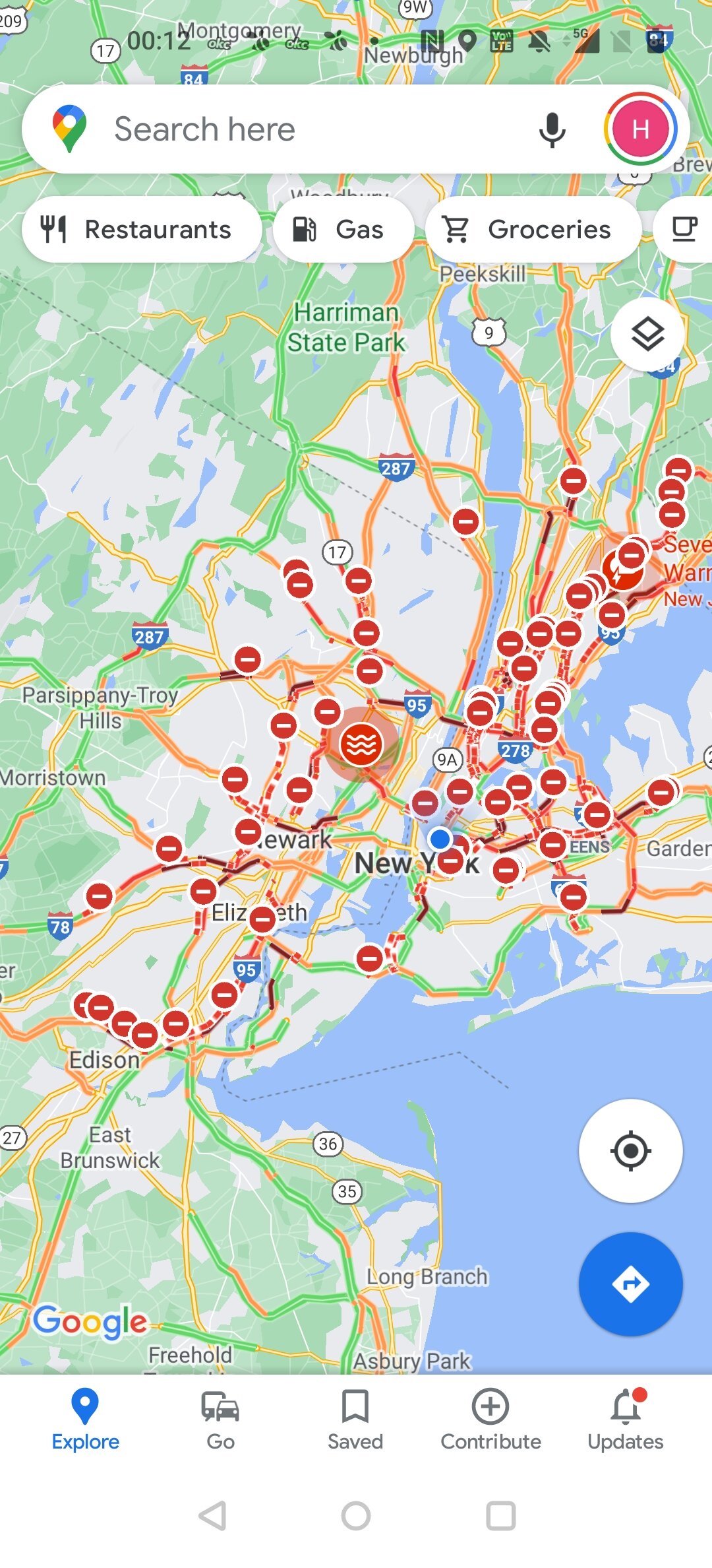
Current road situation....
-
Flash Flood Emergency until 330 for NYC
-
ABC7 just reported that they tried to call 911 for a water rescue and they are getting all circuits are busy in the Bronx...
-
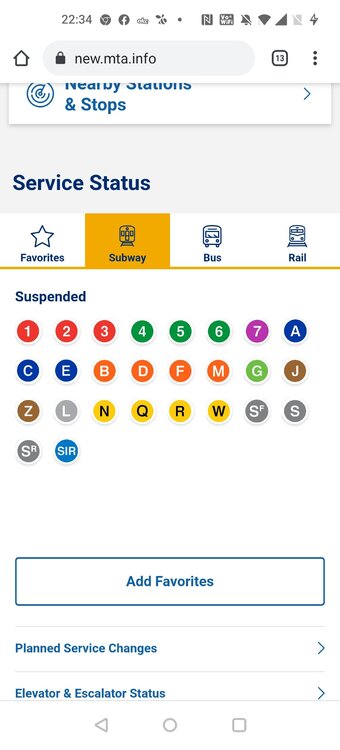
All NYC Subway Lines are suspended.
-
Amazing that the 10pm news spent less than 6 minutes on this.
-
They stupidly built Armstrong Stadiums with openings on the side. When you have wind driven rain it can rain inside.
-
Makes me think about what happened at the Georgia Dome during the SEC Tournament many years ago. Sorry for the banter.
-
Also, the grounds flood. I've been there in heavy rain events. Sure it's just the Jewish Mother in me over worrying though.