Stormpc
-
Posts
3,350 -
Joined
-
Last visited
Content Type
Profiles
Blogs
Forums
American Weather
Media Demo
Store
Gallery
Everything posted by Stormpc
-
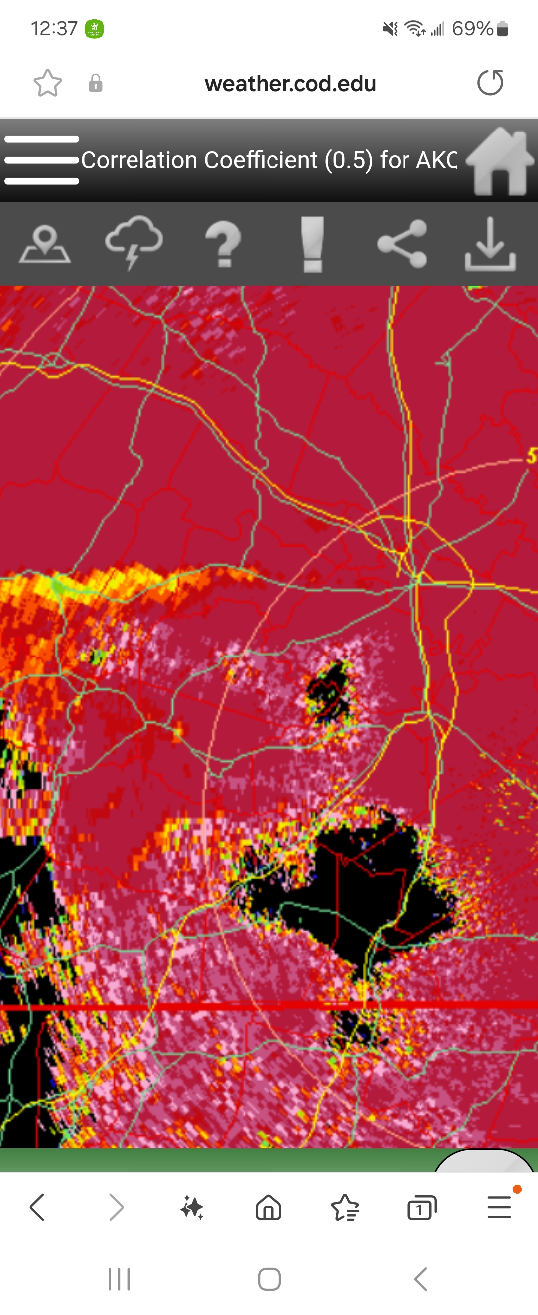
Euro is deadly at mid-range. Let's watch and see if all the other globals and shorter range mesos start falling in line. At least I hope so.
-
GFS still produces nothing for Hampton Roads Southside and North Carolina so I'd rather not pay attention except to look for the trends. I'm going to hug the snowiest models and go to sleep. Thank you CMC.
-
Well that looks pretty nice. Definitely a step further southeast.
-
Do tell!
-
Anybody have the GFS ens members? 18z...
-
Just took a look through the euro. Well. I don't think it would hurt too much in the Richmond area if this came another 50 miles south? Would you all mind if I can join the party a little bit? Even so I get some on both sides of the mix and end up with 3-6. That would be a huge score.
-
GEFS slightly southland push of snow but cut totals a smudge. I like the move. It's not going the other way at least for now
-
GFS nice move toward the euro. It almost feels like this is beginning to get locked in. At least the general idea. Vacillating on the southern end is going to be the issue for us. Well for richmond. Not much for me. I don't have much chance in this game but I'm all in on a peninsula and Central Virginia wipe out
-
30 of 50 EPS members bury you. Certainly not out of the game.
-
Newport News to Williamsburg to lower Eastern Shore special
-
GFS another slider that doesn't phase or turn the corner but still gets Richmond and Central parts of Virginia pretty good. More frozen into Hampton Roads from what it looks like. I don't have precipitation Maps yet
-
Ensembles are all over the place. From too far north. Too far south. A complete miss. Take that run with a grain of salt.
-
Both GFS and Euro have different variations and evolutions of what's going to happen next week on each run. No clue yet. There's going to be something big. From Richmond North is almost a certainty. 6z GFS looks impossible. Euro AI is still offshore.
-
GREAT videos thank you @RIC Airport
-
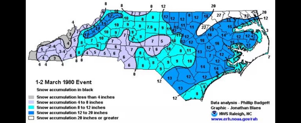
Looks a lot like the March 1980 North Carolina blizzard. Of course this is just for fun. Very little chance that's happening but an interesting comparison
-
18z GFS is a coastal shellacking
-
Anything I get the rest of the way this winter is a bonus. Already had our 7 plus inch event. Blew through climo. I just like to get a taste of some of that colorful snowmap through the tracking process. Doesn't even have to happen. I just like being in the game. I knew when I moved down there I wasn't getting much if anything. I'm surprised I got two events over 6 inches the past 4 years.
-
Don't say that yet. But I get you. I dare to say it's trending South the past two runs across the board. Let's see which way it goes the next two days. I think Richmond is looking good for something pretty significant either way
-
Really? Interesting. I saw the Euro was down but I didn't know it was a larger scale issue affecting other things. One of those Ashburn data centers is the possible culprit. Those buildings are hilarious. They're about a quarter mile long and wide and are six cars parked in the lot.
-
Agree. There's nothing good about ice. Serves zero purpose. Back in the mid-90s through early 2000s we used to get several ice events in NOVA. Nothing much the last 15 years. We can debate about why for days on end. Hopefully that storm next week gets a lot of people involved on this board, from the southeast through new england. Each of these storms have been very regional this year.
-
The big storm is still on the board on the GFS. Most of us would rather take the Canadian version which has a more offshore and southern track. Pretty nice winter storm for the Middle Atlantic the past 24 hours. Lot more ice than I thought. The snow did exactly what it was supposed to do, and where it was supposed to. We need that Saturday system to go through New England to see how it sets up next week's storm. Exciting times for sure.
-
Gonna be a LONG week tracking the next one. We should start seeing something consistent by Friday or Saturday, we should assume. Both majors have something on the table for next Wednesday Thursday. Starting to get into Euro's hot range. But give the GFS credit for being pretty good with yesterday's storm. Too far south to start with but it did adjust North but might have been 30 miles or so off on the southern end. That's not terrible. If I'm in Central Virginia away from the coast I'm feeling pretty good about next week at this time.
-
Very similar to what the Euro was showing as well. We need to keep that storm track south of us.
-
Yeah it's frustrating. Always were on the fence but looks like you're going to be 20 mi too far south for this one. Maybe the next big burst will cool the column enough to flip you back in the next 90 minutes. Whatever happens between now and four p.m. is the time. After that the column warms all the way. You might be looking at plain old rain by 6:00 p.m. sucks.
-