

Stormpc
-
Posts
3,345 -
Joined
-
Last visited
Content Type
Profiles
Blogs
Forums
American Weather
Media Demo
Store
Gallery
Everything posted by Stormpc
-
Yes. Looks like a wet microburst.
-
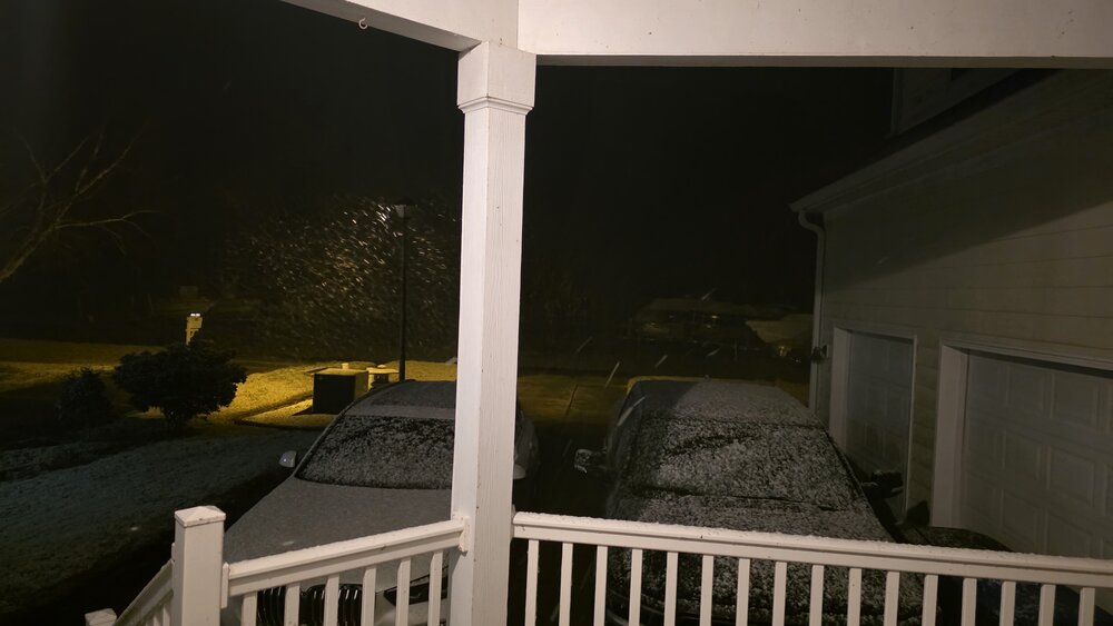
Frozen precipitation in the form of sleet made it all the way to my house. Crazy 24 hour turn of events. A few mangled flakes in there as well as we speak.
-
Agree. I've actually had more snow since I moved down here in 2018 than mild spot in Nova
-
Eh. Just light snow. But it's late February on the Northern Outer Banks and this is all I can ask for. A few good winters here since I've been down this way.
-
Was going to say the same thing. Radar is paltry over me but it's snowing very hard.
-
Doubtful. The winds at the surface at 3 inches are too variable. Can't get a good fetch because of it.
-
Yes it's drying out for us on the Southwest flank of the precipitation. As this thing pulls North. You might be right. We may be done.
-
The tail end of that band is rotating through. It did its job. Laid a solid coating down. Brought the temperatures down near 33. Let's see if this can go on a little longer. I see a little drying to my west.
-
Down to 33.6. Once we flipped to snow it's already starting to stick.
-
34.1. Need some rates or a couple ticks down to see anything on the ground. My cold air came quick. Lots of times it comes down from the Eastern Shore through Virginia Beach and into Northeast North carolina. A lot less land friction. Sometimes it works out this way.
-
I am all snow already. And it's not as wet as I thought it would be. Need some rates to accumulate however
-
Where are you? It's definitely transitioning now down here
-
Im NEXT!!! Definitely more snow mixed in now. Can actually hear it hitting the north side windows of the house
-
Same thing way down here in Currituck. 37/37 ain't going to get it done.
-
Much quicker than I thought. Mangled flakes mixing in with the rain.
-
Im 2 hours away from that!
-
It's coming. I was hovering around 42 for the past 3 hours. Suddenly winds picked up and in about 15 minutes we dropped to 37.
-
Same here. Someone told me you need to use the desktop version.
-
I've got partly sunny skies now. Lots of blue overhead. But it's loud and windy. It's going to be interesting to see how this thing develops and Who cashes in.
-
NYC 11.8 LGA 14.4 ISP 16.7 JFK 12.0 EWR 14.8
-
-
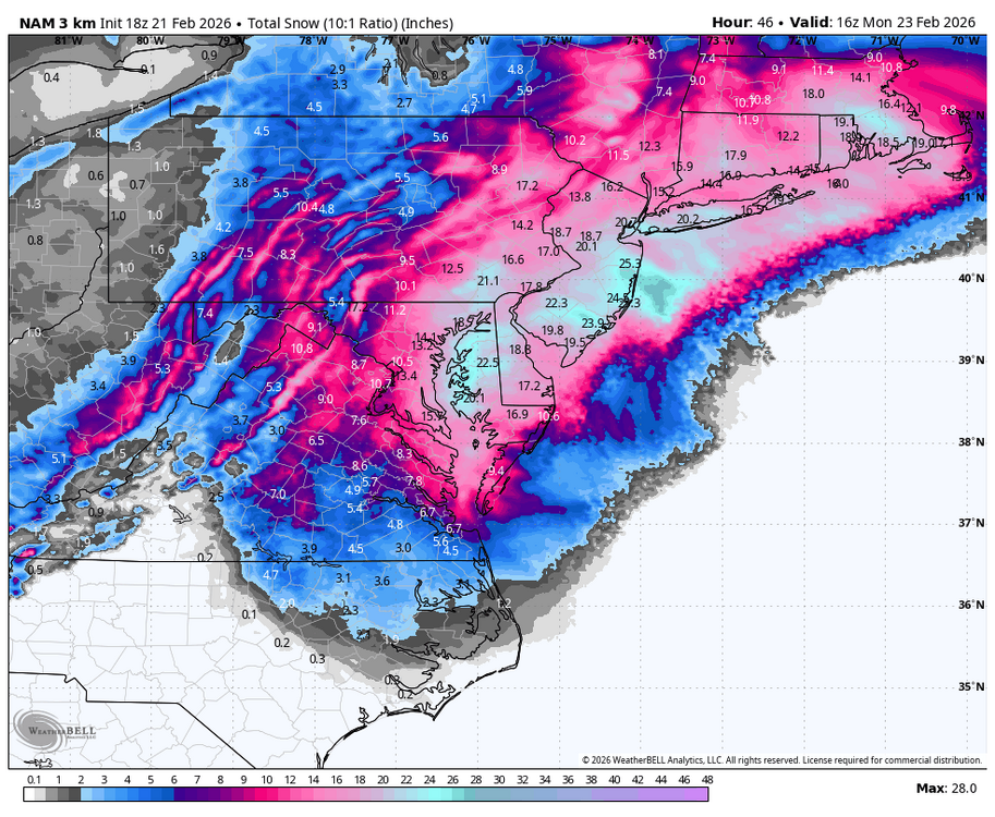
The 3K looks even better.
-
You're looking better and better each model suite now. You're definitely going to see flakes. At least a few inches. That was a great NAM run for RIC and east
-
They really classic big ones always throw a few surprises along the way. Let's see how far back to the Southwest the deform band can get. Will there be more movement west and south with the low? Can it bomb quicker? There's still time for adjustments.
-
I agree. I could see spots along the peninsulas on the East sides over toward the eastern shore of Virginia getting into warning snows easily. You are on the edge of all guidance but trending. I may even see a wet flake or two.


