

Stormpc
-
Posts
3,350 -
Joined
-
Last visited
Content Type
Profiles
Blogs
Forums
American Weather
Media Demo
Store
Gallery
Everything posted by Stormpc
-
-
The 3K looks even better.
-
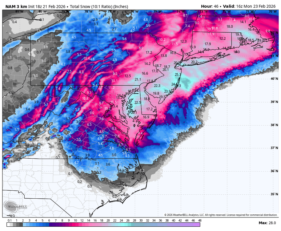
You're looking better and better each model suite now. You're definitely going to see flakes. At least a few inches. That was a great NAM run for RIC and east
-
They really classic big ones always throw a few surprises along the way. Let's see how far back to the Southwest the deform band can get. Will there be more movement west and south with the low? Can it bomb quicker? There's still time for adjustments.
-
I agree. I could see spots along the peninsulas on the East sides over toward the eastern shore of Virginia getting into warning snows easily. You are on the edge of all guidance but trending. I may even see a wet flake or two.
-
I think you're in the ball game for a surprise. You are so close from being in a jackpot zone. Matthews is not too far from you and they can get up to 10 in.
-
4 days out. Not so long range anymore. Definitely some interesting Solutions in there. CMC is just ridiculous.
-
Radar looks exactly like the 18z 12k NAM from yesterday that I mentioned. You always looking for that one inch or bust. Well you got it!!
-
18z 12k NAM brings a nice refresher to Central Virginia and Hampton Roads tomorrow.
-
Snow in Va Beach
-
34.1/31.9 light rain. Occasional ginger. Hopefully this translates to more snow to my north.
-
35.5/32 light rain with a bit of sleet.
-
Light rain to start. 35.4/32.
-
INCOMING.... not sure if it's rain, sleet or snow. Probably rain at least to start but it may be snow further north into Hampton roads.
-
Speaking of OT, big ISLES win last night!
-
Thats a Bob Chill special.
-
The few encouraging 12z high resolution model runs puts everybody in the game.
-
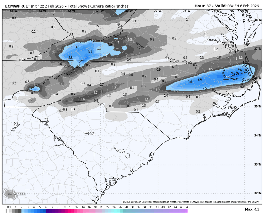
RGEM brings a widespread 3-5 on the south side. 2-4 across most all Hampton roads.
-
EURO!!
-
12z CMC is a hit along the border of North Carolina and Va
-
12Z RGEM giving us a little something to look at Wednesday night after that front goes through. Models are starting to catch on by developing a wave along the front. We'll see.
-
Just came in from outside and have roughly 10 inches. Crazy. Some places well over a foot. Others four inches. Just because of the wind here. But it's been ripping and we're going to get at least four or five more inches. So it's going to be really hard to pinpoint the exact snowfall
-
About 7 inches... could be five. Could be nine. Who the hell knows because of the driting but I think it's about 7.
-
January 30th- Feb 1st ULL and coastal storm obs
Stormpc replied to JoshM's topic in Southeastern States
6+ in Currituck but it's very hard to measure since it's blowing around so much. I have a little spot on the southwest side of my house that is away from the wind and that's what I have so far. -
Its ripping. Sideways snow. Wind is bad. Around 50mph


