

CoastalWx
-
Posts
176,153 -
Joined
-
Last visited
Content Type
Profiles
Blogs
Forums
American Weather
Media Demo
Store
Gallery
Everything posted by CoastalWx
-
Yep. Hopefully it’s not a striated mess on radar.
-
There is a cross hair sig so it could come down good for a couple of hours .
-
Even below that. The cold from 925 up and eroding rather quickly from SW-NE. Maybe far NW CT gets some. Wouldn't shock me if Kevin started as snow or mix.
-
We'd take that.
-
I noticed that too.
-
I'm wondering if the low skirts the CT coastline (maybe just south of you) to SE MA. That limits the warm sector, although still may kiss 50ish.
-
41.6 so far. 39.8 now with east wind. Where’s my AN temps that I was told would happen?
-
I feel like nrn ORH county probably could use an advisory. Maybe not everyone reaches it, but temps are like 34/24 in many spots. It won't get much warmer and may fall a couple after dark. Seems like a quick 2-4 near and above 1K isn't outrageous.
-
Whatever happened to Colonel Lieutenant Ice Warrior Commander?
-
Yep. Looks like after the 15-18th or so. Maybe post 20th to be safe.
-
Iceman cometh.
-
Might be some around. Could really pound paste there.
-
@ineedsnow Goes to your GF's parents place at 1400'. Could be fun there.
-
Might be a combo that delivers a GOAK trough for a time. But I don't see this as Dec '15 like Ray said earlier. Should be workable overall, especially interior.
-
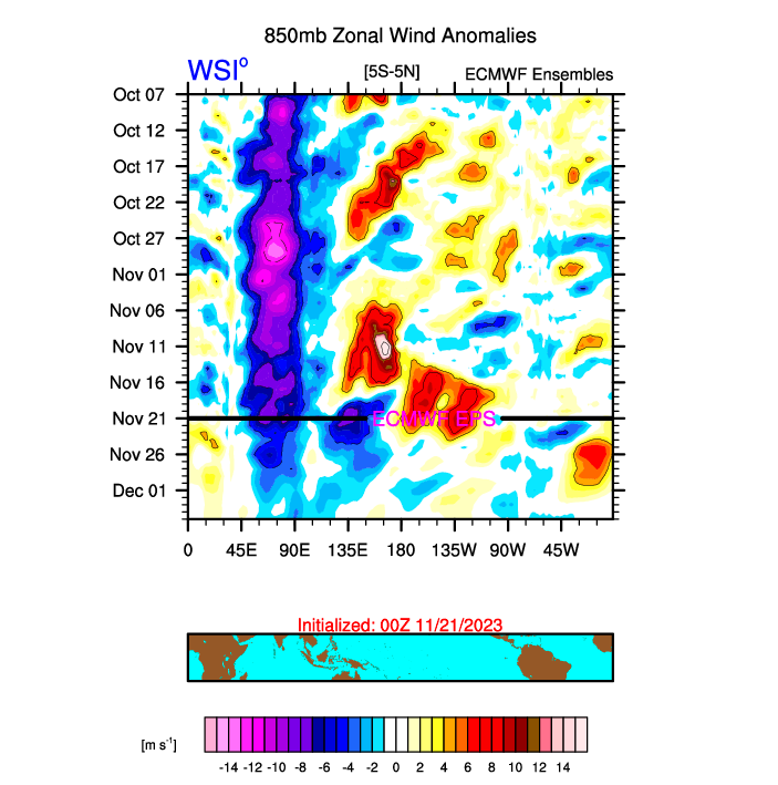
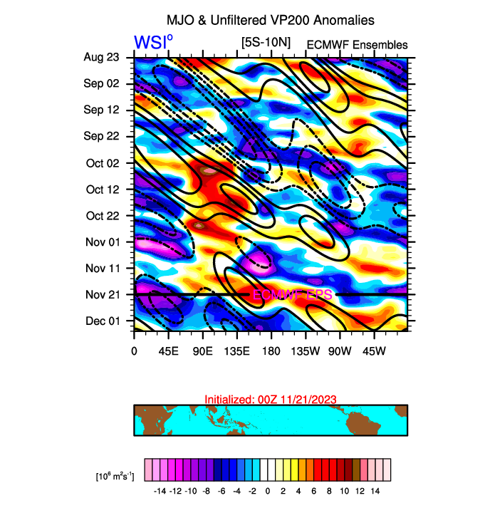
Interesting developments IMO. The current WWB should migrate and weaken with time. After that, I don't see anything notable for the next few weeks so my guess is this peak will be coming soon and if guidance is right, probably peak within the next few weeks? Also note the IO dipole weakens considerably as forecasted. As far as the MJO goes, that has been the main driver of the pattern. If we assume the euro is correct, it looks like we get another wave into the area near and just west of the dateline later on during the first week of December. That probably would mean towards mid December the east may cool off again.
-
I agree
-
I’d put an advisory in SW NH too.
-
Is still keep an eye out next week, but nothing exciting at the moment.
-
Hate to read it.
-
Good thing nobody did.
-
Also with this being MJO driven, some signs maybe this changes mid December. Just some early speculation. Still think sometime before Christmas we try to make a run.
-
I’m just giving my thoughts. I know how models work. It still seems low chance.
-
BOX should have nrn ORH county in an advisory but that’s my opinion. First of the year, travel season for holiday etc. I know it’s late at night, but they’ll probably meet the criteria.
-
Some ensembles still try for a coastal graze next week, but not a high prob thing it seems.
-
Definitely a more Nino December look there at the end of ensembles sometime during the first week of December. Prior to that I don’t see any wintry events, but still possible some S/w flies by and gives a little.


