

CoastalWx
-
Posts
176,041 -
Joined
-
Last visited
Content Type
Profiles
Blogs
Forums
American Weather
Media Demo
Store
Gallery
Everything posted by CoastalWx
-
October Discussion: Bring the Frost-Hold the Snow
CoastalWx replied to 40/70 Benchmark's topic in New England
-
October Discussion: Bring the Frost-Hold the Snow
CoastalWx replied to 40/70 Benchmark's topic in New England
-
That gradient seems intense. It's not like the weather near the notch has been 20 degrees colder compared to where you are. It must be the species of trees too.
-
October Discussion: Bring the Frost-Hold the Snow
CoastalWx replied to 40/70 Benchmark's topic in New England
-
October Discussion: Bring the Frost-Hold the Snow
CoastalWx replied to 40/70 Benchmark's topic in New England
Euro caving. He's gonna save us all. -
October Discussion: Bring the Frost-Hold the Snow
CoastalWx replied to 40/70 Benchmark's topic in New England
Outdoor lunch today. Clothes optional. What a day. -
October Discussion: Bring the Frost-Hold the Snow
CoastalWx replied to 40/70 Benchmark's topic in New England
Tossed -
October Discussion: Bring the Frost-Hold the Snow
CoastalWx replied to 40/70 Benchmark's topic in New England
But you live in the big apple? -
We tried to tell 'em.
-
October Discussion: Bring the Frost-Hold the Snow
CoastalWx replied to 40/70 Benchmark's topic in New England
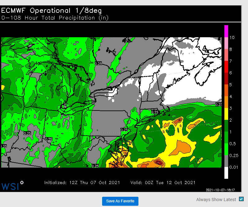
The euro guidance (especially 6z runs) is trying to screw up late Sunday into Monday morning. But even that is mostly a night event. All other guidance is dry. So if one assumes some sort of compromise, my guess is maybe a some shwrs near srn areas..but I don't buy a soaker. Hey if I'm wrong, bump this post. I'll somehow move on. -
October Discussion: Bring the Frost-Hold the Snow
CoastalWx replied to 40/70 Benchmark's topic in New England
Beer? -
Ray walking through his backyard when he gets back.
-
October Discussion: Bring the Frost-Hold the Snow
CoastalWx replied to 40/70 Benchmark's topic in New England
Not sure why Kevin has a fetish to ruin weekends with rain. -
October Discussion: Bring the Frost-Hold the Snow
CoastalWx replied to 40/70 Benchmark's topic in New England
EPS much wetter but focused on Sunday night. Even so, if we can salvage most of Sunday and Monday, it's a win. -
October Discussion: Bring the Frost-Hold the Snow
CoastalWx replied to 40/70 Benchmark's topic in New England
LOL one grid point gets close. What a salesman. -
October Discussion: Bring the Frost-Hold the Snow
CoastalWx replied to 40/70 Benchmark's topic in New England
Couple of light shwrs down by you Sunday night. -
October Discussion: Bring the Frost-Hold the Snow
CoastalWx replied to 40/70 Benchmark's topic in New England
That's half inch to the pike? Barely a quarter. Anyways, now 6z euro is more wet. I'm tossing. -
October Discussion: Bring the Frost-Hold the Snow
CoastalWx replied to 40/70 Benchmark's topic in New England
I won't rule out some shwrs, but for now I am selling a soaker near pike. I hope. -
October Discussion: Bring the Frost-Hold the Snow
CoastalWx replied to 40/70 Benchmark's topic in New England
Might be a little Sunday night your way, but I'm hoping for him to come and squash south. -
October Discussion: Bring the Frost-Hold the Snow
CoastalWx replied to 40/70 Benchmark's topic in New England
Not even sticky. Just a great stretch of weather. -
October Discussion: Bring the Frost-Hold the Snow
CoastalWx replied to 40/70 Benchmark's topic in New England
Seriously though, maybe later Sunday and Monday have clouds and a few showers.....overall a heck of a stretch. Just stop bitching about needing cold and enjoy it. -
October Discussion: Bring the Frost-Hold the Snow
CoastalWx replied to 40/70 Benchmark's topic in New England
No it doesn't. Maybe they'll be some shwrs on south coast. Overall not bad. -
October Discussion: Bring the Frost-Hold the Snow
CoastalWx replied to 40/70 Benchmark's topic in New England
EPS will succumb to Stein too. -
October Discussion: Bring the Frost-Hold the Snow
CoastalWx replied to 40/70 Benchmark's topic in New England
Let’s go -
October Discussion: Bring the Frost-Hold the Snow
CoastalWx replied to 40/70 Benchmark's topic in New England
Gfs ftw


