CoastalWx
-
Posts
176,996 -
Joined
-
Last visited
Content Type
Profiles
Blogs
Forums
American Weather
Media Demo
Store
Gallery
Everything posted by CoastalWx
-
Yeah that probably would blossom nicely overhead.
-
Will you be issuing a first call for the Greens and Whites?
-
Just Dutch ovening weenies since 2008.
-
I was saying yesterday wait until Friday. Although I still feel there isn’t a lot of room for huge deepening, but we shall see.
-
Might even be a few inches above 1K in the Monads.
-
NAM and HRRR still look wintry tomorrow with flakes in the air tomorrow evening and maybe even some coatings in spots.
-
Once it moves over Tolland, CT.
-
I think they’ll be a lot of flakes in the air. Was hoping 00z nam stuff was real, but probably a little too far south for the good stuff.
-
And yes I am jelly, but hopefully a kick start to ski season. We joke about the fake.
-
You throwing out watches?
-
December 2021 Obs/Disco...Dreaming of a White-Weenie Xmas
CoastalWx replied to 40/70 Benchmark's topic in New England
Guidance from Monday through maybe the following Monday has a ton of s/w’s embedded in the flow. Maybe one of them can bring some -SN. I could see that. -
December 2021 Obs/Disco...Dreaming of a White-Weenie Xmas
CoastalWx replied to 40/70 Benchmark's topic in New England
At least Ray has no family home to witness the violence when his December forecast goes up in flames. -
December 2021 Obs/Disco...Dreaming of a White-Weenie Xmas
CoastalWx replied to 40/70 Benchmark's topic in New England
I’m with ya Wolfie. Whatever happens happens. Maybe it improves a bit. -
Lady you’re scaring us.
-
“You kids like em schloppy don’t ya?”
-
Happy Thanksgiving! Enjoy the fake snow.
-
December 2021 Obs/Disco...Dreaming of a White-Weenie Xmas
CoastalWx replied to 40/70 Benchmark's topic in New England
-
The ridge out west has little amplitude. So I guess it’s not a surprise the s/w can’t dig on current guidance. Kind of progressive.
-
Euro actually likes NE Ma tomorrow.
-
December 2021 Obs/Disco...Dreaming of a White-Weenie Xmas
CoastalWx replied to 40/70 Benchmark's topic in New England
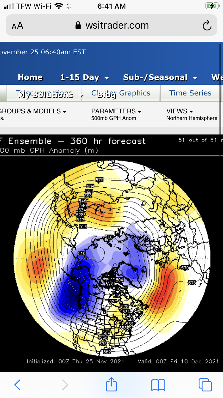
I think there is truth to the EPS unfortunately. Hopefully it starts to reverse a bit. -
December 2021 Obs/Disco...Dreaming of a White-Weenie Xmas
CoastalWx replied to 40/70 Benchmark's topic in New England
Death Star
-
Maybe some flakes.
-
December 2021 Obs/Disco...Dreaming of a White-Weenie Xmas
CoastalWx replied to 40/70 Benchmark's topic in New England
The GEFS are much less of a mess so we hope they are closer to being correct. Maybe that means we compromise. -
Happy Thanksgiving!
-
Models backed away from the snow.