RitualOfTheTrout
-
Posts
3,687 -
Joined
-
Last visited
Content Type
Profiles
Blogs
Forums
American Weather
Media Demo
Store
Gallery
Everything posted by RitualOfTheTrout
-
 Color me skeptical right now, I don't doubt we get colder and have a brief period of NW flow "events" but we are getting to the point in the season where typical Nina response (Western trough, SE Ridge) conflicts with big cold in the East. Maybe the SSW reshuffles the deck so to speak or provides a resurgence of blocking but I'd bet the big cold look is muted as we get closer in time. If we keep the blocking it would probably setup a gradient type pattern with storms riding along the gradient as it wobbles N to South coinciding with -NAO / SE Ridge strength. Maybe some overrunning WAA type storms. This would probably be more towards the end of the month and if it sets up to far north of your desired location it's a warm wet / cold dry type of setup. One could argue we haven't really had the typically expected Enso response in the past few years due to other factors so the entire base for my argument may be moot anyways. Just throwing some gueses out there right now to stir debate since we will be quiet weatherwise for a bit.
 -
Agree, Still some chance we could see minimal precipitation Tuesday but more like the confluence rips it apart. Seems pretty likely we twiddle our thumbs for another week. Glad Winter came in like a lion with a big December or wasting these first two weeks of January would be more frustrating.
-
No discrete threats to follow yet, but looks like we should have a period with a more favorable pattern coming up. That could change (the no discrete threat part) in short notice though with all the short waves flying around. I wouldn’t mind some clippers with some enhancement off the still relatively warm lakes as appetizers for some bigger storms later in the month either. I do think we enter a period where misses South / East are more likely when blocking peaks.
-
Happy New Year everyone! Looks like some solid blocking is showing up on the models. Here's to hopefully more tracking and more importantly big hits in our near future!
-
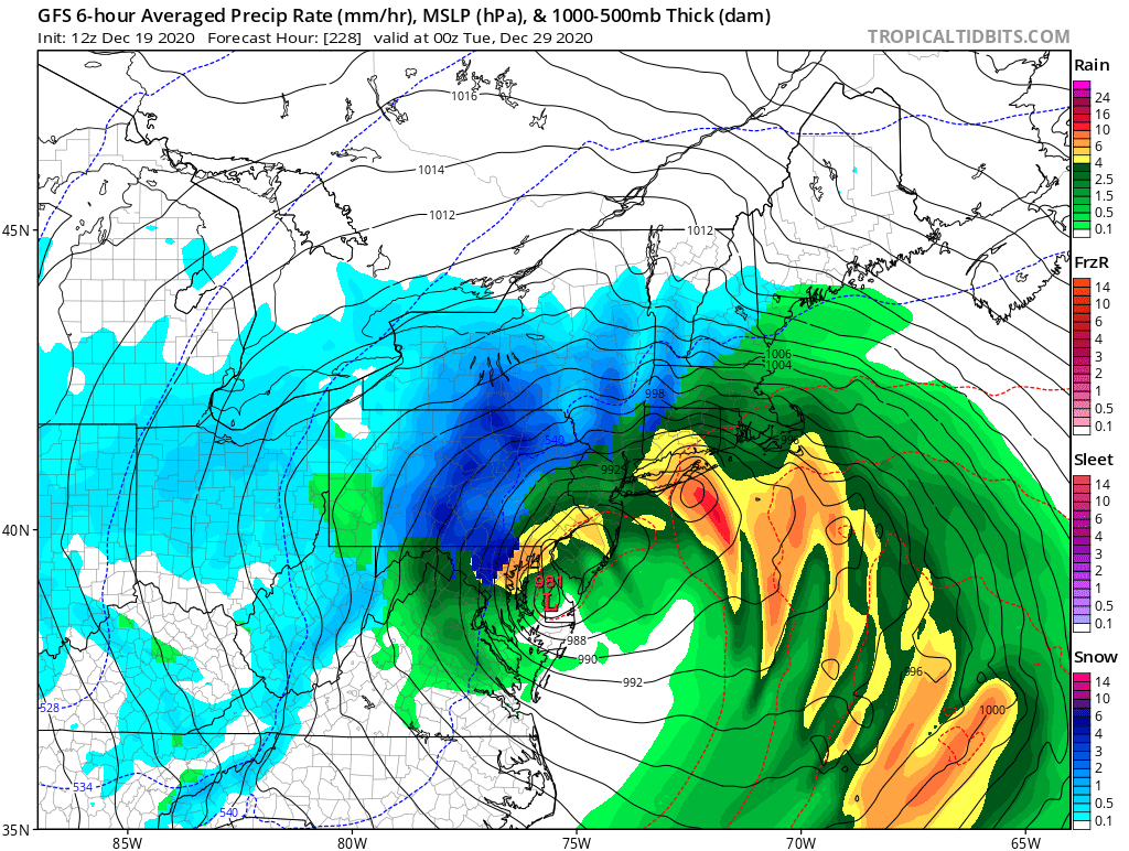
Not terribly informative but a "fun" read while we wait for the next snow threat to track: https://pittsburgh.cbslocal.com/2020/12/29/pittsburgh-weather-snow-winter/?utm_campaign=trueAnthem Manual&utm_medium=trueAnthem&utm_source=facebook&fbclid=IwAR2M6BlBRt27u7OKOMsfswAWa5TvFsAgbDNHj_Pz7SKTf8e-4Mdw4ZkLkzk
-
I'm seeing alot of discussions / debate on whether the higher heights in Greenland are really due to a "true" NAO or just the result of way above normal temperatures inflating past average 500mb heights for this time of year. Still more data says that the precursor to a SSW / PV split is typically above average temperatures for us. All above my pay grade but what I do see is a general lack of cold air. It's odd to see rain on the NW side of a low pressure in early January anywhere let alone up into Canada. I think we just need more time to see how this evolves. Do we end up with the typical Nina response the rest of winter (Nina's are usually front loaded) or does some other factor combined with the a hopefully weakening Nina yield different results. As always expect models to struggle during any change.
-
Next window to watch for sure although 00z Euro and 12z Canadian ops don't really support and even GFS has shifted west. Still 6-7 days out so who knows how it will play out.
-
Still snowing, nothing beats an all day snow, what a perfect Christmas Day weather wise. Snow is picking up again with temperatures in the teens. All out winter right now.
-
Heavy wind driven sleet changing over to snow now. Hoping for 4 but will be happy with 2. Merry Christmas all.
-
It would be for sure, I think it being Christmas day and we will at least salvage a white one helps too. That being said I'm still tad aggravated to see 6-8 so close.
-
I was thinking the same thing, NAM had change to snow between 9 and 10 and that looks pretty good. It's crazy how Allegheny always seems to have such a gradient North to South or East to West and this storm looks to be the same.
-
Not a great setup for LES in our area, the flow tomorrow will turn more WSW which should cut off lake moisture for us.
-
This 100%. Baring a total failure in models we should all at a minimum have a fresh 2 inches on the ground for Christmas day as well as flakes in the air and cold temperatures throughout. Hallmark movie scenery should be had by all. I do think areas east of the city but outside the ridges will be on the lower end which includes my yard. Further West you go from the city towards Ohio stand a better chance to bust high but models will struggle nailing down a 25 mile shift one way or the other.
-
NWS PBZ pretty bullish too, 4-6 inches: Timing for the change over looks to be sometime between 6pm-11pm With the GFS being quicker and NAM / Canadian a bit slower. Part of me is actually hoping for a later switch (assuming it doesn't affect totals). I think it will be an awesome transformation from bare ground to winter wounder land when the kids wake up.
-
GFS seems to have sped up the front, now coming through Thursday morning, seems it doesn’t really spin up a wave along the front until later which is probably why it’s a bit faster. Is it right, who knows?
-
Just had to lol when I saw SWPA rain while it snows in every other direction.

-
GFS (and other models) are showing a wave of low pressure develop and ride up along the strong cold front projected to move through. It's all heavily timing dependent, front has to clear just as the wave moves past your latitude then deepen and slow the progression of the front to see those big totals. Don't get invested in anything you see with this, it won't be resolved until very short lead times. As for a white Christmas, (I'm just going with the ground is covered, not the official 1 inch of new snow mark) odds are better than normal looking ahead. I think our current snow pack stands a good chance of holding up at least until Wednesday. We have generally overcast, with temperatures in the low to mid 30s with potentially reinforcing shots of light snow added on top Sunday / Monday. If we can drop below freezing overnight combined with weakest sun angle of the year practically and a higher liquid equivalent snow pack we should be good. My only concern is Wednesday, we could make a run into the mid 40s maybe 50. A screaming SW wind with high dew points will eat a snow pack fast. Even if that does happen though, there is a chance with post frontal snow (even if the best case scenario doesn't happen) and some LES behind we could add enough new snow to recover the ground if it came to that. Just my 2 cents..
-
Well I went to work Wednesday planning to only work a half day but some things came up and ended up working 18 hours and missing the whole storm practically outside of looking out the window every half hour or so. Driving home at midnight was fun lol It was a nice storm for us, driving back in today it was so picturesque like a Bob Ross painting.
-
It's crazy when you think about it but true. Can we get another storm and make it a December to remember?
-
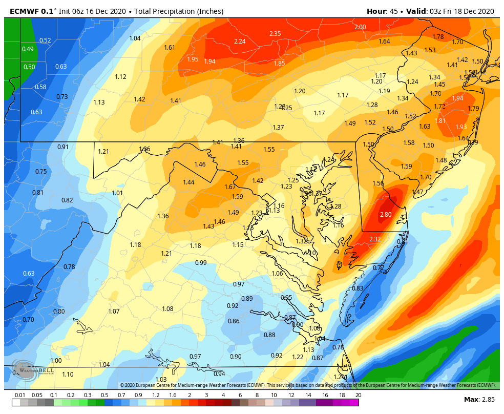
It is tough to gauge these maps with various snow algorithms when trying to ascertain what has changed one run to another etc. Here is 6z Euro total qpf. Looks like Allegheny ranges from about .6 - .8 from east to west across the county. Obviously snow growth / ratios will determine what that equates to on the ground but seems pretty reasonable imho the city should end up with around 6-7 inches. GFS is a tenth or so less .5-.7 across the county and the 3k NAM is probably right in the middle of the two. If this holds for 12z runs we are game on. The trend we saw in my opinion had a little bit to do with both the storm moving a bit SE and the models coming down to earth on qpf amounts due to getting a better handle on where the CCB sets up, which they all tend to be high at range. I personally never bought into any of those maps showing 10+, for something like that we really need the closed low feature. I think that was one of Joe Denardo's rules of thumb for big snows for our area, if you aren't on the northern periphery of a closed 700mb low be very careful forecasting big snows.

-
NWS upped totals in the warning from 5-8 to 6-9 I see.
-
I'm busy pouring blood over my snow idol statue, conducting a seance to conjur the snow gods and various other paranormal rituals of the ocult to give me temporary control over mother nature to keep any east trends at bay. Oh yeah.. I mean me too.. just eating some dinner.
-
Central PA - Winter 2020/2021
RitualOfTheTrout replied to MAG5035's topic in Upstate New York/Pennsylvania
Good, I'll have my lawyers ready the contract for signature. -
For now the 18z NAM is well within the envelope of tracks. If we see a similar issue in the rest of 18z data and a continuation in 00z then you could argue a trend back SE is underway but we are running out of time and the goal posts should be fairly narrow at this point.
-
Looks pretty similar to Euro. We are getting close enough now I fully expected the NAM to come back down to earth. Honestly 14 is still probably overdone.