-
Posts
3,673 -
Joined
-
Last visited
Content Type
Profiles
Blogs
Forums
American Weather
Media Demo
Store
Gallery
Everything posted by RitualOfTheTrout
-
Western PA/Pittsburgh Winter 2021/22 Discussion
RitualOfTheTrout replied to meatwad's topic in Upstate New York/Pennsylvania
Everything I've seen the FRAM method is way more accurate (still not perfect) in forecasting ice accretion so I'm glad you posted a map that's utilizing that. If anyone needs any bed time reading, here is agreat article on the science of freezing rain: https://journals.ametsoc.org/view/journals/wefo/31/4/waf-d-15-0118_1.xml -

Western PA/Pittsburgh Winter 2021/22 Discussion
RitualOfTheTrout replied to meatwad's topic in Upstate New York/Pennsylvania
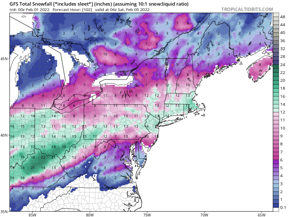
I hope so... but not because anyone really expects to get 10 clean inches of snow out of this in our local area.. If so I can already hear the crying. -

Western PA/Pittsburgh Winter 2021/22 Discussion
RitualOfTheTrout replied to meatwad's topic in Upstate New York/Pennsylvania
It looks like at least on the GFS between 4pm - 7pm the front will be sliding across Allegheny county, NAM is more like 7pm - 10pm. GFS did tick slightly faster at 12z than 6z but still slower than 00z, we are really talking like 25-50 miles differences here which is probably just run to run noise but if you are on the eastern edge it makes a difference. -

Western PA/Pittsburgh Winter 2021/22 Discussion
RitualOfTheTrout replied to meatwad's topic in Upstate New York/Pennsylvania
Draw a line from City of Pittsburgh to Clarion, the further North / West you go will be rapidly increasing impacts. South and East of that line rapidly decreasing impacts. That's my take based on looking at all the 6z data / 12z NAM. Still almost 36 hours until we get into the part of the storm we are all interested in, so any minor adjustments one way or the other will have big influence on sensible weather. Slower / Less amped look of that wave is what we want, but the trends have been slightly in the opposite direction on the GFS / NAM so lots of stuff to track / analyze. The front really slows down as I mentioned before, and there is some warm nose influence as the freezing line even bumps NW a little bit. Looks like the counties NWS has highlighted in the watch currently is a good call although I could see an expansion eastward with advisories. Most counties currently in the watch would hit warning criteria based on freezing rain. -

Western PA/Pittsburgh Winter 2021/22 Discussion
RitualOfTheTrout replied to meatwad's topic in Upstate New York/Pennsylvania
So I compared when the 2M temperatures fell below 32 on the 6z GFS to 6z Euro, both have it through Allegheny County by 00z Friday (7PM Thursday) with about .75 - 1 inch of qpf over the next 24 hours afterwards. NAM is similar but about 6 hours slower. That's going to be my benchmark for comparing whether we see the front slow down more. Euro has been speeding it up and GFS slowing it down, but they are both about the same so that might have just been the goalposts narrowing. The frustrating part is the front makes decent progress, then gets hung up right before it passes through Allegheny county Thursday afternoon. I think if that second wave slows down the front probably clears sooner. The upper levels are really going to come down to nowcast time, using the surface freezing temperature as a benchmark to see how this is trending should give some insight. -

Western PA/Pittsburgh Winter 2021/22 Discussion
RitualOfTheTrout replied to meatwad's topic in Upstate New York/Pennsylvania
I'm with you on this, pretty zen on the whole situation. It's like we are a last place underdog that had no business making the playoffs yet here we are. -

Western PA/Pittsburgh Winter 2021/22 Discussion
RitualOfTheTrout replied to meatwad's topic in Upstate New York/Pennsylvania
Best run of the Euro yet since it jumped way North a couple days ago. GFS didn't "cave" from what I saw, was maybe 25 mile NW, well within any error at this range, and the NAM well it's the NAM. Let's see what 00z does, if things keep going the wrong way then you start to think maybe it's not going to work out. I really don't get all the melting in this thread earlier. -

Western PA/Pittsburgh Winter 2021/22 Discussion
RitualOfTheTrout replied to meatwad's topic in Upstate New York/Pennsylvania
Wait…. So we have the GFS and Euro came in faster with the cold and would be impactful with sleet and freezing rain but we are burning it all down and killing the rest of FEB over one 18z NAM run!? Lol Im by no means discounting a slower push of cold and we plain rain, it’s been on the table and honestly the more likely scenario but a bit premature reaction off one run of one cycle. If we see the others go North then yeah it’s game over but it’s still not like we lost 18in of snow in 6 hours. -

Western PA/Pittsburgh Winter 2021/22 Discussion
RitualOfTheTrout replied to meatwad's topic in Upstate New York/Pennsylvania
This is what I thought too, yes the wave is slightly weaker more strung out, but the whole thing is more progressive too, so those areas that were getting hit by both waves had higher totals now there is a larger swath of decent snow. In any event if we have to sacrifice someone else's snow to have an interesting event here I'll throw that baby into the volcano everytime, we have like 8 - 9 months out of the year for plain rain. Give me something wintry over plain rain any day in mid winter. -

Western PA/Pittsburgh Winter 2021/22 Discussion
RitualOfTheTrout replied to meatwad's topic in Upstate New York/Pennsylvania
Probably also means the Canadian won't be making any big jumps towards the GFS. Man, what a battle, something is going bust pretty badly and I hope it's not the one that gives us the most snow. -

Western PA/Pittsburgh Winter 2021/22 Discussion
RitualOfTheTrout replied to meatwad's topic in Upstate New York/Pennsylvania
Wouldn't it be nice for the cold air to win out and come in faster than modeled like what usually happens to us with the warm nose? If it's going to happen this is probably the type of setup to do it with a strong arctic boundary pressing and a decent 1040+ high in a good position to the north. I'd feel better being west / north of the city right now but I wouldn't be too upset over 2-4 inches of sleet either, that is something pretty unusual. One can hope. Sure looks like your move is paying off this winter eh? -

Western PA/Pittsburgh Winter 2021/22 Discussion
RitualOfTheTrout replied to meatwad's topic in Upstate New York/Pennsylvania
Yeah comparing hour to hour vs previous run it's maybe ever so slightly colder / faster with the cold push but for someone that's going to make a big difference. I hope we can get like the Canadian and Euro to get closer to the GFS, that would instill a lot of confidence that this is turning the right way. At least the NAM is making the move. -

Western PA/Pittsburgh Winter 2021/22 Discussion
RitualOfTheTrout replied to meatwad's topic in Upstate New York/Pennsylvania
Yes, big jump towards the GFS, gets the cold in much faster ahead of that second wave. Now watch the GFS go North at 12z. -

Western PA/Pittsburgh Winter 2021/22 Discussion
RitualOfTheTrout replied to meatwad's topic in Upstate New York/Pennsylvania
I feel like it's been awhile since I looked at the BUFKIT tables, but here is the big difference, GFS gets KPIT almost 7 inches of snow and like a tenth of ice, NAM gets KPIT almost .9 of ice, but its all with temperatures between 29-32 6z GFS StnID: kpit Profile Thermal Adjust: 0.0 Cloud RH threshold: 85% Average Hourly Sounding: NO Date/hour FHr Wind SfcT Ptype SR |Snow||Sleet|| FZRA|| QPF CumSR|TotSN||TotPL||TotZR|| TQPF S%| I%| L% ============================================================================================================================ 220202/2300Z 41 16007KT 36.9F RAIN 0:1| 0.0|| 0.00|| 0.00|| 0.032 0:1| 0.0|| 0.00|| 0.00|| 0.03 0| 0|100 220203/0000Z 42 16008KT 37.5F RAIN 0:1| 0.0|| 0.00|| 0.00|| 0.059 0:1| 0.0|| 0.00|| 0.00|| 0.09 0| 0|100 ----------------------------------------------+----++-----+-------------++--------------++-------------++-----------+---+--- 220203/0100Z 43 16008KT 38.2F RAIN 0:1| 0.0|| 0.00|| 0.00|| 0.052 0:1| 0.0|| 0.00|| 0.00|| 0.14 0| 0|100 220203/0200Z 44 17007KT 38.2F RAIN 0:1| 0.0|| 0.00|| 0.00|| 0.016 0:1| 0.0|| 0.00|| 0.00|| 0.16 0| 0|100 220203/0300Z 45 17006KT 38.0F RAIN 0:1| 0.0|| 0.00|| 0.00|| 0.016 0:1| 0.0|| 0.00|| 0.00|| 0.17 0| 0|100 220203/0400Z 46 18006KT 37.8F RAIN 0:1| 0.0|| 0.00|| 0.00|| 0.026 0:1| 0.0|| 0.00|| 0.00|| 0.20 0| 0|100 220203/0500Z 47 19005KT 38.2F RAIN 0:1| 0.0|| 0.00|| 0.00|| 0.046 0:1| 0.0|| 0.00|| 0.00|| 0.25 0| 0|100 220203/0600Z 48 23003KT 37.3F RAIN 0:1| 0.0|| 0.00|| 0.00|| 0.034 0:1| 0.0|| 0.00|| 0.00|| 0.28 0| 0|100 ----------------------------------------------+----++-----+-------------++--------------++-------------++-----------+---+--- 220203/0700Z 49 32003KT 35.3F RAIN 0:1| 0.0|| 0.00|| 0.00|| 0.040 0:1| 0.0|| 0.00|| 0.00|| 0.32 0| 0|100 220203/0800Z 50 34006KT 32.1F FZRA 0:1| 0.0|| 0.00|| 0.00|| 0.026 0:1| 0.0|| 0.00|| 0.00|| 0.35 0| 0|100 220203/0900Z 51 33006KT 29.4F FZRA 0:1| 0.0|| 0.00|| 0.01|| 0.014 0:1| 0.0|| 0.00|| 0.01|| 0.36 0| 0|100 220203/1000Z 52 34007KT 27.9F SNPL 1:1| 0.0|| 0.03|| 0.00|| 0.015 1:1| 0.0|| 0.03|| 0.01|| 0.38 17| 83| 0 220203/1100Z 53 34006KT 27.0F SNPL 2:1| 0.0|| 0.03|| 0.00|| 0.022 2:1| 0.1|| 0.06|| 0.01|| 0.40 31| 69| 0 220203/1200Z 54 35007KT 26.7F FZRA 0:1| 0.0|| 0.00|| 0.02|| 0.020 2:1| 0.1|| 0.06|| 0.04|| 0.42 0| 0|100 ----------------------------------------------+----++-----+-------------++--------------++-------------++-----------+---+--- 220203/1300Z 55 35007KT 26.0F SNPL 1:1| 0.0|| 0.05|| 0.00|| 0.029 1:1| 0.1|| 0.11|| 0.04|| 0.45 12| 88| 0 220203/1400Z 56 35008KT 25.6F SNPL 1:1| 0.0|| 0.03|| 0.00|| 0.020 1:1| 0.1|| 0.14|| 0.04|| 0.47 14| 86| 0 220203/1500Z 57 36007KT 25.2F FZRA 0:1| 0.0|| 0.00|| 0.02|| 0.015 1:1| 0.1|| 0.14|| 0.05|| 0.48 0| 2| 98 220203/1600Z 58 35008KT 25.6F 0:1| 0.0|| 0.00|| 0.00|| 0.000 1:1| 0.1|| 0.14|| 0.05|| 0.48 0| 0| 0 220203/1700Z 59 36007KT 25.1F SNPL 5:1| 0.1|| 0.03|| 0.00|| 0.026 2:1| 0.3|| 0.17|| 0.05|| 0.51 46| 54| 0 220203/1800Z 60 01008KT 24.7F PL 0:1| 0.0|| 0.15|| 0.00|| 0.074 2:1| 0.3|| 0.32|| 0.05|| 0.58 5| 95| 0 ----------------------------------------------+----++-----+-------------++--------------++-------------++-----------+---+--- 220203/1900Z 61 36008KT 24.9F SNPL 2:1| 0.1|| 0.10|| 0.00|| 0.055 2:1| 0.3|| 0.41|| 0.05|| 0.64 12| 88| 0 220203/2000Z 62 01008KT 24.3F ZRPL 0:1| 0.0|| 0.04|| 0.05|| 0.072 2:1| 0.3|| 0.45|| 0.11|| 0.71 0| 28| 72 220203/2100Z 63 01008KT 24.0F SNPL 2:1| 0.2|| 0.13|| 0.00|| 0.078 2:1| 0.5|| 0.58|| 0.11|| 0.79 19| 81| 0 220203/2200Z 64 01009KT 23.1F SNOW 13:1| 0.9|| 0.00|| 0.00|| 0.067 5:1| 1.4|| 0.58|| 0.11|| 0.85 100| 0| 0 220203/2300Z 65 01009KT 22.2F SNOW 10:1| 1.0|| 0.00|| 0.00|| 0.104 6:1| 2.4|| 0.58|| 0.11|| 0.96 100| 0| 0 220204/0000Z 66 01010KT 21.5F SNOW 10:1| 0.7|| 0.00|| 0.00|| 0.076 6:1| 3.2|| 0.58|| 0.11|| 1.03 100| 0| 0 ----------------------------------------------+----++-----+-------------++--------------++-------------++-----------+---+--- 220204/0100Z 67 01010KT 20.9F SNOW 8:1| 0.6|| 0.00|| 0.00|| 0.065 7:1| 3.7|| 0.58|| 0.11|| 1.10 100| 0| 0 220204/0200Z 68 01010KT 20.0F SNOW 8:1| 0.6|| 0.00|| 0.00|| 0.073 7:1| 4.3|| 0.58|| 0.11|| 1.17 100| 0| 0 220204/0300Z 69 01010KT 18.9F SNOW 7:1| 0.5|| 0.00|| 0.00|| 0.064 7:1| 4.7|| 0.58|| 0.11|| 1.24 100| 0| 0 220204/0400Z 70 01010KT 18.4F SNOW 11:1| 0.6|| 0.00|| 0.00|| 0.052 7:1| 5.3|| 0.58|| 0.11|| 1.29 100| 0| 0 220204/0500Z 71 02010KT 18.0F SNOW 10:1| 0.4|| 0.00|| 0.00|| 0.044 7:1| 5.8|| 0.58|| 0.11|| 1.33 100| 0| 0 220204/0600Z 72 02008KT 18.0F SNOW 9:1| 0.4|| 0.00|| 0.00|| 0.043 7:1| 6.1|| 0.58|| 0.11|| 1.38 100| 0| 0 ----------------------------------------------+----++-----+-------------++--------------++-------------++-----------+---+--- 220204/0700Z 73 01008KT 17.9F SNOW 7:1| 0.4|| 0.00|| 0.00|| 0.053 7:1| 6.5|| 0.58|| 0.11|| 1.43 100| 0| 0 220204/0800Z 74 02008KT 17.7F SNOW 7:1| 0.3|| 0.00|| 0.00|| 0.038 7:1| 6.7|| 0.58|| 0.11|| 1.47 100| 0| 0 220204/0900Z 75 01008KT 17.5F SNOW 9:1| 0.3|| 0.00|| 0.00|| 0.035 7:1| 7.1|| 0.58|| 0.11|| 1.50 100| 0| 0 220204/1000Z 76 02008KT 17.1F SNOW 5:1| 0.2|| 0.00|| 0.00|| 0.036 7:1| 7.2|| 0.58|| 0.11|| 1.54 100| 0| 0 220204/1100Z 77 02007KT 17.0F SNOW 6:1| 0.1|| 0.00|| 0.00|| 0.009 7:1| 7.3|| 0.58|| 0.11|| 1.55 100| 0| 0 220204/1200Z 78 02007KT 16.6F SNOW 13:1| 0.1|| 0.00|| 0.00|| 0.011 7:1| 7.5|| 0.58|| 0.11|| 1.56 100| 0| 0 ----------------------------------------------+----++-----+-------------++--------------++-------------++-----------+---+--- 220204/1300Z 79 01007KT 16.6F SNOW 6:1| 0.1|| 0.00|| 0.00|| 0.014 7:1| 7.5|| 0.58|| 0.11|| 1.57 100| 0| 0 220204/1400Z 80 01007KT 17.3F SNOW 8:1| 0.1|| 0.00|| 0.00|| 0.008 7:1| 7.6|| 0.58|| 0.11|| 1.58 100| 0| 0 6Z NAM StnID: kpit Profile Thermal Adjust: 0.0 Cloud RH threshold: 85% Average Hourly Sounding: NO Date/hour FHr Wind SfcT Ptype SR |Snow||Sleet|| FZRA|| QPF CumSR|TotSN||TotPL||TotZR|| TQPF S%| I%| L% ============================================================================================================================ 220203/0000Z 42 13006KT 38.9F RAIN 0:1| 0.0|| 0.00|| 0.00|| 0.017 0:1| 0.0|| 0.00|| 0.00|| 0.02 0| 0|100 ----------------------------------------------+----++-----+-------------++--------------++-------------++-----------+---+--- 220203/0100Z 43 15006KT 39.1F RAIN 0:1| 0.0|| 0.00|| 0.00|| 0.033 0:1| 0.0|| 0.00|| 0.00|| 0.05 0| 0|100 220203/0200Z 44 15009KT 39.5F RAIN 0:1| 0.0|| 0.00|| 0.00|| 0.070 0:1| 0.0|| 0.00|| 0.00|| 0.12 0| 0|100 220203/0300Z 45 16009KT 39.6F RAIN 0:1| 0.0|| 0.00|| 0.00|| 0.024 0:1| 0.0|| 0.00|| 0.00|| 0.14 0| 0|100 220203/0400Z 46 17008KT 39.6F RAIN 0:1| 0.0|| 0.00|| 0.00|| 0.009 0:1| 0.0|| 0.00|| 0.00|| 0.15 0| 0|100 220203/0500Z 47 18007KT 39.6F RAIN 0:1| 0.0|| 0.00|| 0.00|| 0.031 0:1| 0.0|| 0.00|| 0.00|| 0.19 0| 0|100 220203/0600Z 48 18007KT 39.8F RAIN 0:1| 0.0|| 0.00|| 0.00|| 0.019 0:1| 0.0|| 0.00|| 0.00|| 0.20 0| 0|100 ----------------------------------------------+----++-----+-------------++--------------++-------------++-----------+---+--- 220203/0700Z 49 19007KT 40.2F RAIN 0:1| 0.0|| 0.00|| 0.00|| 0.012 0:1| 0.0|| 0.00|| 0.00|| 0.22 0| 0|100 220203/0800Z 50 21005KT 40.5F RAIN 0:1| 0.0|| 0.00|| 0.00|| 0.008 0:1| 0.0|| 0.00|| 0.00|| 0.22 0| 0|100 220203/0900Z 51 24003KT 40.4F RAIN 0:1| 0.0|| 0.00|| 0.00|| 0.012 0:1| 0.0|| 0.00|| 0.00|| 0.24 0| 0|100 220203/1000Z 52 29004KT 39.6F RAIN 0:1| 0.0|| 0.00|| 0.00|| 0.020 0:1| 0.0|| 0.00|| 0.00|| 0.26 0| 0|100 220203/1100Z 53 32007KT 35.9F RAIN 0:1| 0.0|| 0.00|| 0.00|| 0.021 0:1| 0.0|| 0.00|| 0.00|| 0.28 0| 0|100 220203/1200Z 54 34008KT 31.0F FZRA 0:1| 0.0|| 0.00|| 0.01|| 0.008 0:1| 0.0|| 0.00|| 0.01|| 0.28 0| 0|100 ----------------------------------------------+----++-----+-------------++--------------++-------------++-----------+---+--- 220203/1300Z 55 34007KT 28.8F FZRA 0:1| 0.0|| 0.00|| 0.02|| 0.017 0:1| 0.0|| 0.00|| 0.03|| 0.30 0| 0|100 220203/1400Z 56 35006KT 28.5F FZRA 0:1| 0.0|| 0.00|| 0.05|| 0.050 0:1| 0.0|| 0.00|| 0.08|| 0.35 0| 0|100 220203/1500Z 57 36006KT 28.8F FZRA 0:1| 0.0|| 0.00|| 0.04|| 0.041 0:1| 0.0|| 0.00|| 0.12|| 0.39 0| 0|100 220203/1600Z 58 01006KT 29.4F FZRA 0:1| 0.0|| 0.00|| 0.05|| 0.052 0:1| 0.0|| 0.00|| 0.18|| 0.44 0| 0|100 220203/1700Z 59 36007KT 29.4F FZRA 0:1| 0.0|| 0.00|| 0.05|| 0.046 0:1| 0.0|| 0.00|| 0.23|| 0.49 0| 0|100 220203/1800Z 60 01007KT 29.4F FZRA 0:1| 0.0|| 0.00|| 0.04|| 0.042 0:1| 0.0|| 0.00|| 0.27|| 0.53 0| 0|100 ----------------------------------------------+----++-----+-------------++--------------++-------------++-----------+---+--- 220203/1900Z 61 02007KT 29.4F FZRA 0:1| 0.0|| 0.00|| 0.03|| 0.024 0:1| 0.0|| 0.00|| 0.29|| 0.56 0| 0|100 220203/2000Z 62 03008KT 29.7F FZRA 0:1| 0.0|| 0.00|| 0.04|| 0.039 0:1| 0.0|| 0.00|| 0.34|| 0.60 0| 0|100 220203/2100Z 63 02008KT 30.6F FZRA 0:1| 0.0|| 0.00|| 0.08|| 0.072 0:1| 0.0|| 0.00|| 0.41|| 0.67 0| 0|100 220203/2200Z 64 01010KT 31.0F FZRA 0:1| 0.0|| 0.00|| 0.11|| 0.106 0:1| 0.0|| 0.00|| 0.52|| 0.77 0| 0|100 220203/2300Z 65 03010KT 29.4F FZRA 0:1| 0.0|| 0.00|| 0.08|| 0.081 0:1| 0.0|| 0.00|| 0.61|| 0.85 0| 0|100 220204/0000Z 66 05009KT 30.1F FZRA 0:1| 0.0|| 0.00|| 0.05|| 0.051 0:1| 0.0|| 0.00|| 0.66|| 0.91 0| 0|100 ----------------------------------------------+----++-----+-------------++--------------++-------------++-----------+---+--- 220204/0100Z 67 01008KT 31.5F FZRA 0:1| 0.0|| 0.00|| 0.16|| 0.154 0:1| 0.0|| 0.00|| 0.82|| 1.06 0| 0|100 220204/0200Z 68 35009KT 32.1F FZRA 0:1| 0.0|| 0.00|| 0.00|| 0.121 0:1| 0.0|| 0.00|| 0.82|| 1.18 0| 0|100 220204/0300Z 69 35010KT 29.2F FZRA 0:1| 0.0|| 0.00|| 0.04|| 0.043 0:1| 0.0|| 0.00|| 0.87|| 1.22 0| 0|100 220204/0400Z 70 35010KT 27.9F ZRPL 0:1| 0.0|| 0.01|| 0.03|| 0.033 0:1| 0.0|| 0.01|| 0.90|| 1.26 0| 15| 85 220204/0500Z 71 35010KT 26.9F ZRPL 0:1| 0.0|| 0.05|| 0.04|| 0.062 0:1| 0.0|| 0.06|| 0.93|| 1.32 0| 42| 58 220204/0600Z 72 35009KT 26.5F ZRPL 0:1| 0.0|| 0.09|| 0.02|| 0.063 0:1| 0.0|| 0.16|| 0.95|| 1.38 0| 74| 26 ----------------------------------------------+----++-----+-------------++--------------++-------------++-----------+---+--- 220204/0700Z 73 35009KT 25.6F PL 0:1| 0.0|| 0.10|| 0.00|| 0.051 0:1| 0.0|| 0.26|| 0.95|| 1.43 0|100| 0 220204/0800Z 74 35009KT 24.0F PL 0:1| 0.0|| 0.05|| 0.00|| 0.026 0:1| 0.0|| 0.31|| 0.95|| 1.46 0|100| 0 220204/0900Z 75 35009KT 22.5F SNPL 2:1| 0.0|| 0.02|| 0.00|| 0.018 2:1| 0.0|| 0.33|| 0.95|| 1.48 48| 52| 0 220204/1000Z 76 35008KT 21.3F SNOW 7:1| 0.1|| 0.00|| 0.00|| 0.014 4:1| 0.1|| 0.33|| 0.95|| 1.49 100| 0| 0 220204/1100Z 77 35008KT 20.2F SNOW 10:1| 0.3|| 0.00|| 0.00|| 0.031 7:1| 0.4|| 0.33|| 0.95|| 1.52 100| 0| 0 220204/1200Z 78 35008KT 19.7F SNOW 7:1| 0.0|| 0.00|| 0.00|| 0.005 7:1| 0.5|| 0.33|| 0.95|| 1.53 100| 0| 0 ----------------------------------------------+----++-----+-------------++--------------++-------------++-----------+---+--- 220204/1300Z 79 35007KT 19.3F SNOW 8:1| 0.1|| 0.00|| 0.00|| 0.010 7:1| 0.6|| 0.33|| 0.95|| 1.54 100| 0| 0 220204/1400Z 80 34007KT 19.8F 0:1| 0.0|| 0.00|| 0.00|| 0.000 7:1| 0.6|| 0.33|| 0.95|| 1.54 0| 0| 0 -

Western PA/Pittsburgh Winter 2021/22 Discussion
RitualOfTheTrout replied to meatwad's topic in Upstate New York/Pennsylvania
Once we get into 3k NAM territory start paying attention to how it does with 2m temperatures etc. It's not great with precipitation amounts but it does seem to do pretty well depicting warm layers etc and has a better handle on p-type with its higher resolution. I think part of this will depend how much surfaces warm today and tomorrow with highs getting above freezing ground temperatures will warm up some so that may be overcome as well but if we keep snow cover maybe that won't matter much. I'm trying to remember the last time we had rain changing to freezing rain, I think it was probably 4 years ago with an arctic front approaching. We did get ice but it transitioned to sleet faster than forecast, that's what I'm hoping for with this. Part of me wouldn't mind seeing a sleet bomb and if that's your expectation its not the same as expecting a big all snow storm then hearing pinging 3 hours into it. This time I'll be hoping to hear it unless by some miraculous turn of events we can get more snow. -

Western PA/Pittsburgh Winter 2021/22 Discussion
RitualOfTheTrout replied to meatwad's topic in Upstate New York/Pennsylvania
Taken in isolation, the 6z GFS basically held, the little NW trend could just be considered noise. 6z NAM also looks to be closer to the GFS now. However for those especially east and south of the city, not seeing all the other models make a significant jump towards the GFS makes me think we might end up seeing something more in between. I think it's going to be painful as locations 20 miles away might be reporting heavy sleet etc while it rains at 31.5 degrees in my yard. Even the NWS WSW doesn't include Armstrong / Westmoreland. If I was in NW Allegheny SW Butler I'd feel pretty good about seeing some interesting weather vs my location given current models. Will need to see how things evolve as we get closer, if the GFS continues to hold its ground and we keep seeing incremental adjustments towards it I'd start to feel a bit better and expect WSW to expand eastward some. -

Western PA/Pittsburgh Winter 2021/22 Discussion
RitualOfTheTrout replied to meatwad's topic in Upstate New York/Pennsylvania
There’s a ton of sleet probably counted as snow but still. Something’s got to start caving one way or the other soon you’d think. -

Western PA/Pittsburgh Winter 2021/22 Discussion
RitualOfTheTrout replied to meatwad's topic in Upstate New York/Pennsylvania
Alright…wtf… who stole the GFS super computer cluster and is running it in their basement with modified physics code? It can’t be this different from the rest and be correct can it? Lol -

Western PA/Pittsburgh Winter 2021/22 Discussion
RitualOfTheTrout replied to meatwad's topic in Upstate New York/Pennsylvania
Well, I expected GFS to make a move towards the more NW models, but it’s actually coming in SE with the boundary at 00z. -

Western PA/Pittsburgh Winter 2021/22 Discussion
RitualOfTheTrout replied to meatwad's topic in Upstate New York/Pennsylvania
Interesting. Crazy what happened there. Amazing nobody was killed. I'll be interested to hear from an engineering perspective why it failed and whether inspections really conveyed the state it was in and it was ignored / overlooked or the inspection was lacking. Anyways 18z GEFS have several good members. This setup is clear as mud right now. Would be nice to see the Euro make a move towards the GFS. As it stands GFS is a very impactful storm, but we still need faster frontal passage for more snow. -

Western PA/Pittsburgh Winter 2021/22 Discussion
RitualOfTheTrout replied to meatwad's topic in Upstate New York/Pennsylvania
Oh wow, what do they have you doing there? -

Western PA/Pittsburgh Winter 2021/22 Discussion
RitualOfTheTrout replied to meatwad's topic in Upstate New York/Pennsylvania
I'm interested to see what happens here. I had all but given up on anything but mainly rain with some mostly inconsequential wintry precipitation on the back end, then I saw the 6z/12z GFS. None of the models look like the GFS, its a SE outlier even among it's own ensembles. I have a feeling it's miss handling something. It seems to be the only one slowing down the ejection of the energy in the south west and having it come out in weaker pieces vs a more consolidated system. If it keeps holding through 18z / 00z tonight it will really be setting up a fairly big fail for either itself or the rest of the gang. We still don't know much about any new biases that may have been introduced since the last upgrade so who knows. It did alright with the blizzard but I think it ended up being to far east granted it was more right in the day 4 range with it and the MLK storm so.. grab a bowl of popcorn and see what happens. -

Western PA/Pittsburgh Winter 2021/22 Discussion
RitualOfTheTrout replied to meatwad's topic in Upstate New York/Pennsylvania
GFS is the new Master of all things forecasting right? The other models are a few cycles behind and just need to catch up.. That's what I'm going with lol, anything to have the positive vibes. -

Western PA/Pittsburgh Winter 2021/22 Discussion
RitualOfTheTrout replied to meatwad's topic in Upstate New York/Pennsylvania
I actually thought the Canadian was a bit worse early on with the front having a more North to South orientation, then towards the end looked a bit better and we ended with more snow on the end. -

Western PA/Pittsburgh Winter 2021/22 Discussion
RitualOfTheTrout replied to meatwad's topic in Upstate New York/Pennsylvania
I'm with you, I'll gladly take a slop storm in reverse progression... rn to zr to ip to sn+ lol


