Voyager
-
Posts
13,317 -
Joined
Content Type
Profiles
Blogs
Forums
American Weather
Media Demo
Store
Gallery
Everything posted by Voyager
-

Central PA Summer 2026 Discussion/Obs Thread
Voyager replied to Voyager's topic in Upstate New York/Pennsylvania
Out of area, but I'm at work. The sun came out here in Allentown, and it got instantly hot and humid... -
Central PA Summer 2026 Discussion/Obs Thread
Voyager replied to Voyager's topic in Upstate New York/Pennsylvania
Well, hopefully those who saw them this past weekend won't see them again. -
Central PA Summer 2026 Discussion/Obs Thread
Voyager replied to Voyager's topic in Upstate New York/Pennsylvania
It seems to be shaping up to be the roller coaster summer I thought it would be. The severity of the storms I didn't expect, though. -
Central PA Summer 2026 Discussion/Obs Thread
Voyager replied to Voyager's topic in Upstate New York/Pennsylvania
As did me. I got .26" overnight. Parts of Berks and Luzerne Counties got pummeled... -
Central PA Summer 2026 Discussion/Obs Thread
Voyager replied to Voyager's topic in Upstate New York/Pennsylvania
I was wondering, all the maps and discussions are and were focused on central and eastern PA, and right now all the action is out west. -
Central PA Summer 2026 Discussion/Obs Thread
Voyager replied to Voyager's topic in Upstate New York/Pennsylvania
Bright overcast (no sun) all day here in both Allentown and Tamaqua. The humidity is awful though. -
E PA/NJ/DE Summer 2026 Obs/Discussion
Voyager replied to PhiEaglesfan712's topic in Philadelphia Region
Has the Jordan Creek ever come close to flooding route 100 by Hoffman's garage or the KOA turnoff? -
Central PA Summer 2026 Discussion/Obs Thread
Voyager replied to Voyager's topic in Upstate New York/Pennsylvania
I guess I should apologize for my rant last night. A lot of you had damage and I'm sure some are still without power this morning. That sucks. I guess I just love good, solid storms, and for some reason Tamaqua is protected from getting them, so it's frustrating to miss out on so many highly anticipated storm outbreaks. -
Central PA Summer 2026 Discussion/Obs Thread
Voyager replied to Voyager's topic in Upstate New York/Pennsylvania
And it was another nothingburger here. Rain has already tapered off, wind and lightning nearly non-existent. Same as it ever was... -
Central PA Summer 2026 Discussion/Obs Thread
Voyager replied to Voyager's topic in Upstate New York/Pennsylvania
I'll be very surprised if we don't end up with just a garden variety shower till all is said and done. The air already cooled to 80 from everyone else's storms. I think we end up getting robbed today. -
Central PA Summer 2026 Discussion/Obs Thread
Voyager replied to Voyager's topic in Upstate New York/Pennsylvania
Massive Tamaqua Split at the moment. Storms up in Scranton and Williamsport and down Harrisburg way. My only hope is what's out by State College and Altoona getting here intact, but as it appears it would be after 9pm, I doubt it. -
Central PA Summer 2026 Discussion/Obs Thread
Voyager replied to Voyager's topic in Upstate New York/Pennsylvania
Only 94 here today. It's looking, at the moment anyway, that any storms my way are going to come after 8pm. I wonder how much energy they'll lose after sunset... -
Central PA Summer 2026 Discussion/Obs Thread
Voyager replied to Voyager's topic in Upstate New York/Pennsylvania
So I see a watch is up for Western PA. I thought it was Eastern PA that was under the gun for storms again tonight. Did I miss something? -
Central PA Summer 2026 Discussion/Obs Thread
Voyager replied to Voyager's topic in Upstate New York/Pennsylvania
The last two days we hit 90 before 10am. Today at 1pm were only at 89. I wonder how much last night's storm is playing into the slightly cooler temp today. -
Central PA Summer 2026 Discussion/Obs Thread
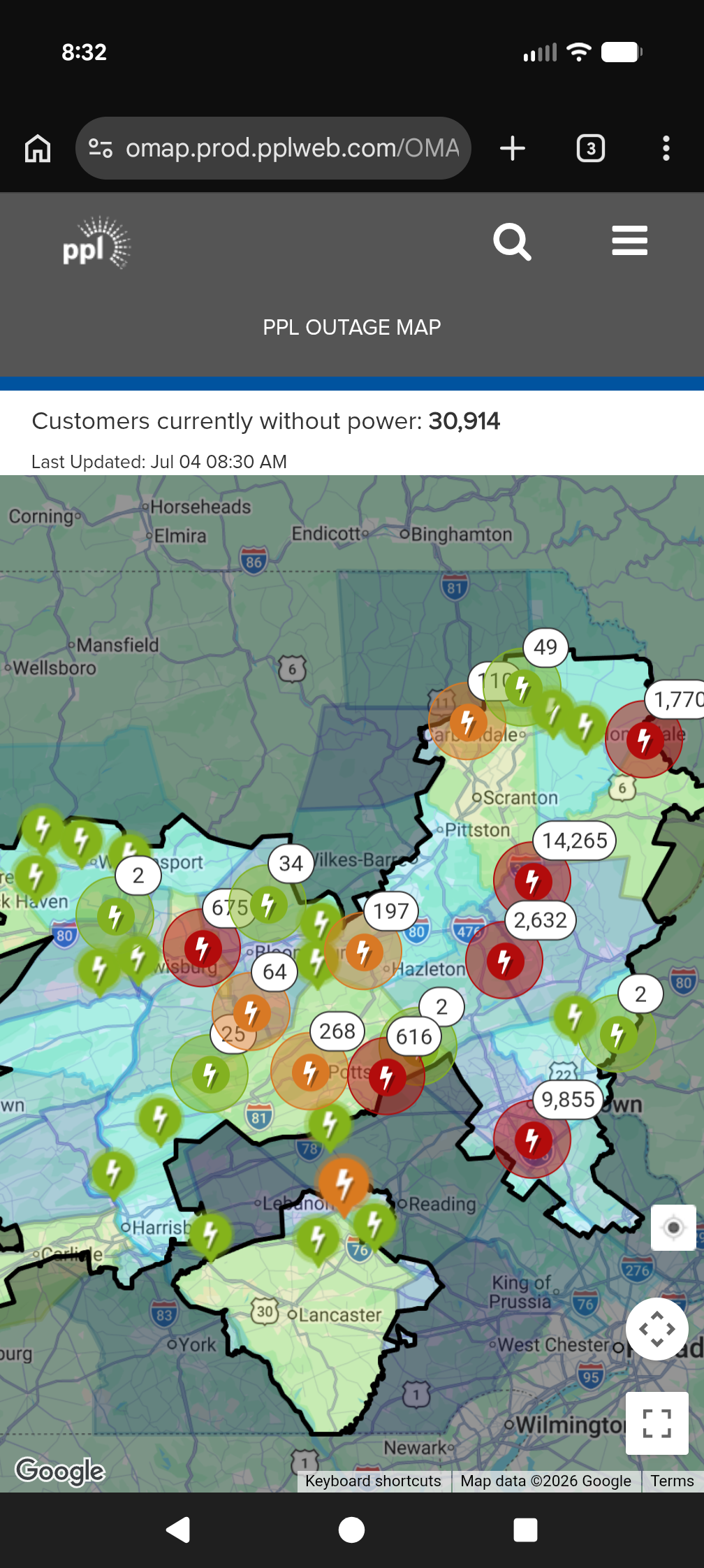
Voyager replied to Voyager's topic in Upstate New York/Pennsylvania
Storms blew up east of I-81 yesterday late afternoon/evening and caused quite a bit of damage in various locations as I posted about last night. 31,000 people are still without power this morning.
-
Central PA Summer 2026 Discussion/Obs Thread
Voyager replied to Voyager's topic in Upstate New York/Pennsylvania
Facebook post with lots of damage photos. https://www.facebook.com/share/p/1Bu5gWgPKs/ -
Central PA Summer 2026 Discussion/Obs Thread
Voyager replied to Voyager's topic in Upstate New York/Pennsylvania
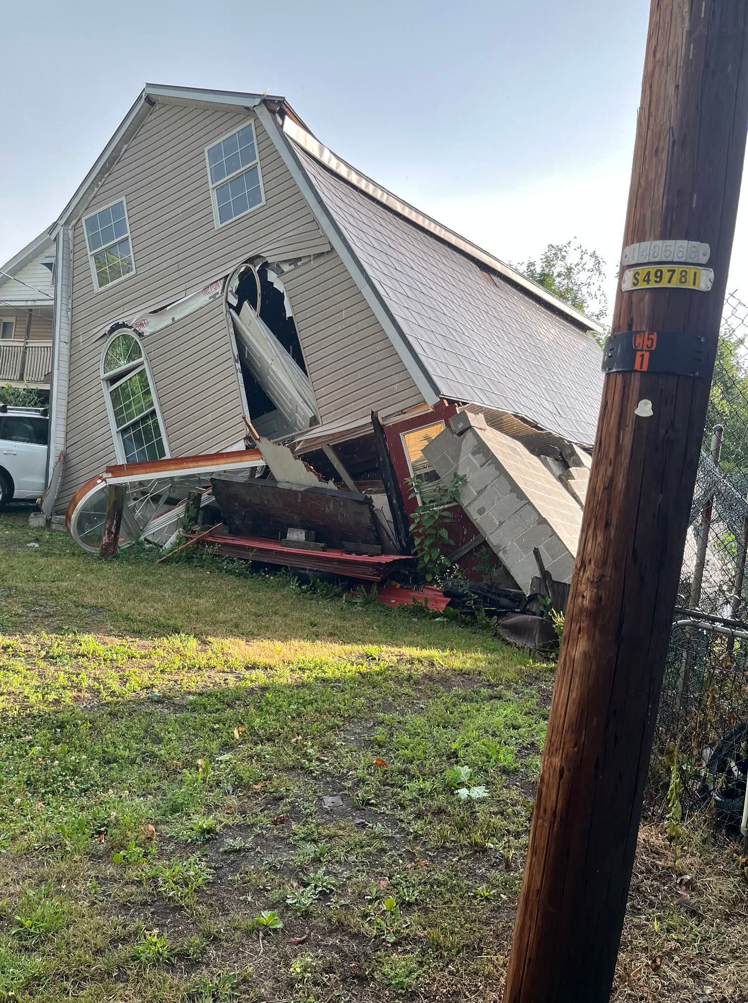
The house/building in New Ringgold.
-
Central PA Summer 2026 Discussion/Obs Thread
Voyager replied to Voyager's topic in Upstate New York/Pennsylvania
Just found out New Ringgold, southwest of Tamaqua got hit hard as well. Saw a photo as well as verified reports of a building collapse. Pic looked like it was a house. -
Central PA Summer 2026 Discussion/Obs Thread
Voyager replied to Voyager's topic in Upstate New York/Pennsylvania
And it did just that. Lehighton got walloped. Trees and wires down everywhere. Here, hardly anything. -
Central PA Summer 2026 Discussion/Obs Thread
Voyager replied to Voyager's topic in Upstate New York/Pennsylvania
Things are starting to get interesting with regard to storms. Looks like some good cells are popping from Williamsport to Bloomsburg moving southeast. -
E PA/NJ/DE Summer 2026 Obs/Discussion
Voyager replied to PhiEaglesfan712's topic in Philadelphia Region
When I lived in Arizona, 115+ was somewhat common in Phoenix, but the hottest temperature I've ever experienced was 128 in Bullhead City. That was just crazy hot, and pretty much too hot for even this summer loving warmanista. The heat radiating up from the asphalt parking lots almost literally burned my legs. -
Central PA Summer 2026 Discussion/Obs Thread
Voyager replied to Voyager's topic in Upstate New York/Pennsylvania
It's why I have the guy on ignore. Him posting his climate stats and obs here, would be the equivalent of me doing it in the Mid Atlantic forum. Now I do post from time to time in the Philly thread, but I'm five miles from Carbon and 8 miles from Lehigh, so sometimes I cross over. Plus...I was born and raised in Bethlehem, so I feel a kindred spirit with those guys down there. -
Central PA Summer 2026 Discussion/Obs Thread
Voyager replied to Voyager's topic in Upstate New York/Pennsylvania
Exactly. That's why I went. Of course it wasn't as bad at 11am in Tamaqua as it was in the afternoon farther south toward Reading and beyond. -
E PA/NJ/DE Summer 2026 Obs/Discussion
Voyager replied to PhiEaglesfan712's topic in Philadelphia Region
I was lucky the train came through Tamaqua around 11am, before peak heating, but it was still plenty hot. There were a handful of heat emergencies here, though, too. -
Central PA Summer 2026 Discussion/Obs Thread
Voyager replied to Voyager's topic in Upstate New York/Pennsylvania
Yup. The 4012 is up there on static display. For a bit, they parked the operating Big Boy next to the static one.