Voyager
-
Posts
13,276 -
Joined
Content Type
Profiles
Blogs
Forums
American Weather
Media Demo
Store
Gallery
Everything posted by Voyager
-

Central PA Summer 2026 Discussion/Obs Thread
Voyager replied to Voyager's topic in Upstate New York/Pennsylvania
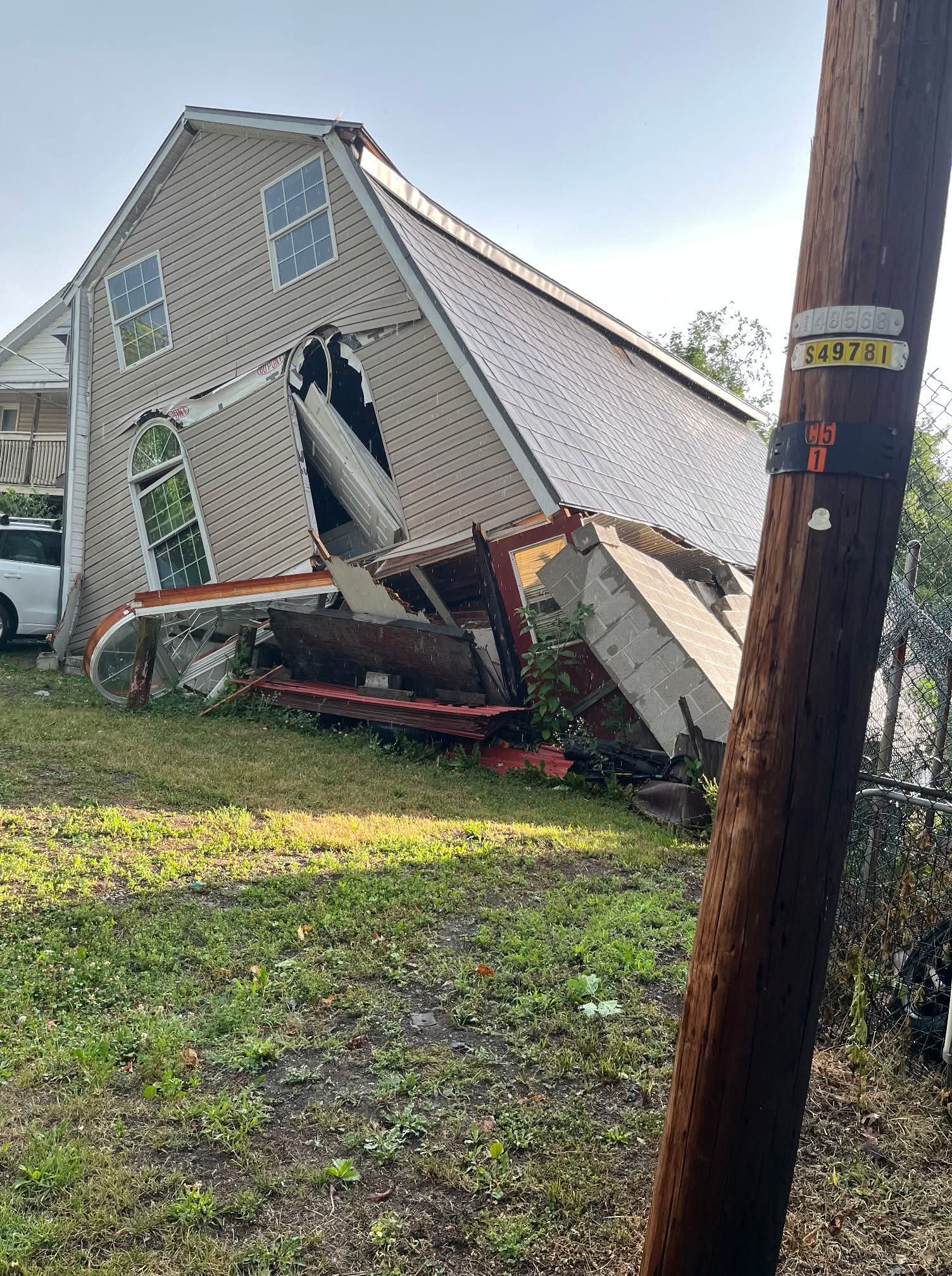
The house/building in New Ringgold.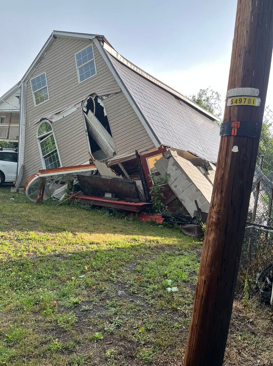
-
Central PA Summer 2026 Discussion/Obs Thread
Voyager replied to Voyager's topic in Upstate New York/Pennsylvania
Just found out New Ringgold, southwest of Tamaqua got hit hard as well. Saw a photo as well as verified reports of a building collapse. Pic looked like it was a house. -
Central PA Summer 2026 Discussion/Obs Thread
Voyager replied to Voyager's topic in Upstate New York/Pennsylvania
And it did just that. Lehighton got walloped. Trees and wires down everywhere. Here, hardly anything. -
Central PA Summer 2026 Discussion/Obs Thread
Voyager replied to Voyager's topic in Upstate New York/Pennsylvania
Things are starting to get interesting with regard to storms. Looks like some good cells are popping from Williamsport to Bloomsburg moving southeast. -
E PA/NJ/DE Summer 2026 Obs/Discussion
Voyager replied to PhiEaglesfan712's topic in Philadelphia Region
When I lived in Arizona, 115+ was somewhat common in Phoenix, but the hottest temperature I've ever experienced was 128 in Bullhead City. That was just crazy hot, and pretty much too hot for even this summer loving warmanista. The heat radiating up from the asphalt parking lots almost literally burned my legs. -
Central PA Summer 2026 Discussion/Obs Thread
Voyager replied to Voyager's topic in Upstate New York/Pennsylvania
It's why I have the guy on ignore. Him posting his climate stats and obs here, would be the equivalent of me doing it in the Mid Atlantic forum. Now I do post from time to time in the Philly thread, but I'm five miles from Carbon and 8 miles from Lehigh, so sometimes I cross over. Plus...I was born and raised in Bethlehem, so I feel a kindred spirit with those guys down there. -
Central PA Summer 2026 Discussion/Obs Thread
Voyager replied to Voyager's topic in Upstate New York/Pennsylvania
Exactly. That's why I went. Of course it wasn't as bad at 11am in Tamaqua as it was in the afternoon farther south toward Reading and beyond. -
E PA/NJ/DE Summer 2026 Obs/Discussion
Voyager replied to PhiEaglesfan712's topic in Philadelphia Region
I was lucky the train came through Tamaqua around 11am, before peak heating, but it was still plenty hot. There were a handful of heat emergencies here, though, too. -
Central PA Summer 2026 Discussion/Obs Thread
Voyager replied to Voyager's topic in Upstate New York/Pennsylvania
Yup. The 4012 is up there on static display. For a bit, they parked the operating Big Boy next to the static one. -
Central PA Summer 2026 Discussion/Obs Thread
Voyager replied to Voyager's topic in Upstate New York/Pennsylvania
-
Central PA Summer 2026 Discussion/Obs Thread
Voyager replied to Voyager's topic in Upstate New York/Pennsylvania
It's looking like 98 is going to be my high for today. -
Central PA Summer 2026 Discussion/Obs Thread
Voyager replied to Voyager's topic in Upstate New York/Pennsylvania
As Canderson said, I have the Tempest station. I like it a lot, but with the hepatic rain gauge, you're not going to get accurate winter precipitation readings, as the snowflakes aren't heavy enough to trip the sensors. You'll need a separate gauge to melt and record snow. -
Central PA Summer 2026 Discussion/Obs Thread
Voyager replied to Voyager's topic in Upstate New York/Pennsylvania
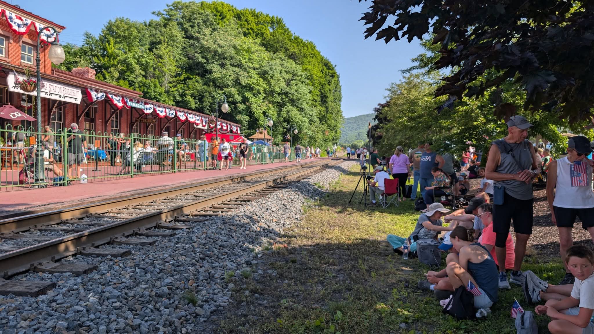
Still an hour from train time, and Tamaqua is full of people trackside already...
-
Central PA Summer 2026 Discussion/Obs Thread
Voyager replied to Voyager's topic in Upstate New York/Pennsylvania
If I can get some good stuff, I will! -
Central PA Summer 2026 Discussion/Obs Thread
Voyager replied to Voyager's topic in Upstate New York/Pennsylvania
Oh, I most certainly will! I took a vacation day because the Union Pacific Big Boy is coming through Tamaqua today. I live so close to the tracks that it's practically going through my backyard. I could sit on my back patio and watch it go by, but it's doing a 15 minute photo stop at the train station, so I'll be walking down there to see it, and hopefully get some good pics and video. -
Central PA Summer 2026 Discussion/Obs Thread
Voyager replied to Voyager's topic in Upstate New York/Pennsylvania
Facebook certainly has a warped sense of humor. Look at this ad that showed up in my feed just now...
-
Central PA Summer 2026 Discussion/Obs Thread
Voyager replied to Voyager's topic in Upstate New York/Pennsylvania
Looks like 96.3 is going to be the high for today here. -
Central PA Summer 2026 Discussion/Obs Thread
Voyager replied to Voyager's topic in Upstate New York/Pennsylvania
I might have to go into the witness protection program after posting this...
-
Central PA Summer 2026 Discussion/Obs Thread
Voyager replied to Voyager's topic in Upstate New York/Pennsylvania
My total for June was 4.35". -
Central PA Summer 2026 Discussion/Obs Thread
Voyager replied to Voyager's topic in Upstate New York/Pennsylvania
Even here, Thursday and Friday are 99 and 98 respectively. On top of that, I can't ever remember Schuylkill County being included in an Extreme Heat Warning, let alone for multiple days. Back in 2011, we hit 103, unofficially, on my weather station. It'll be interesting to see what I register with this one. -
Central PA Summer 2026 Discussion/Obs Thread
Voyager replied to Voyager's topic in Upstate New York/Pennsylvania
Why couldn't today have been yesterday's weather? I needed a morale booster so bad, and instead, I got the opposite. -
Central PA Summer 2026 Discussion/Obs Thread
Voyager replied to Voyager's topic in Upstate New York/Pennsylvania
What an f'n miserable day. I haven't felt good, physically or mentally, for the past 6 months, and needed a nice day out. Instead mother nature, or God, or whomever, doubled down and just made things worse. I just can't seem to win anymore... -
Central PA Summer 2026 Discussion/Obs Thread
Voyager replied to Voyager's topic in Upstate New York/Pennsylvania
Today is the wife's employer's annual Knoebels summer picnic. Of course the worst weather a week before and week after would be today. And by that I mean the rain. The overcast and moderate temperatures would make for a nice, comfortable day otherwise. -
Central PA Summer 2026 Discussion/Obs Thread
Voyager replied to Voyager's topic in Upstate New York/Pennsylvania
We did well here, too. 0.83" overnight. The "storm" after midnight must have had a pretty good wind component to it, because I registered an 18.6mph gust at 12:35am, which, for my station and it's protected location, is quite impressive. Even on the windiest of days, I rarely record a gust over 15mph. -
Central PA Summer 2026 Discussion/Obs Thread
Voyager replied to Voyager's topic in Upstate New York/Pennsylvania
Well, I am a water hauler, so maybe as snow begets snow, water begets water...lol