

wxsniss
-
Posts
5,523 -
Joined
-
Last visited
Content Type
Profiles
Blogs
Forums
American Weather
Media Demo
Store
Gallery
Posts posted by wxsniss
-
-
This run also a tick warmer at 925 especially east...
Agree 4-10" is a safe range this far ahead for much of eSNE.
Still think there is a shot at >10" somewhere 128-495 or interior southeast depending on timing of interaction. But we need to see more support for that tomorrow, otherwise today's most bullish runs were a flash in the pan.
-
 1
1
-
-
Definite step back from 12z Euro... interaction with trailing energy occurred too late
But, we at least appear to be stabilizing the floor of a solid region-wide warning event, which appears on all guidance.
The double-digit ceiling is critically dependent on that infusion of trailing wave, and on this 0z Euro the lead wave scoots east / that interaction is delayed. This will fluctuate and definitely still on the table.
Ironic that GFS is now the most robust (at least for SNE).
-
Shifted east with lead wave compared to 12z... the mitigating factor mentioned earlier if trailing wave interacts later
-
4 minutes ago, ORH_wxman said:
NAM was prob gonna go apeshit the next frame with that potent vort trying to crash the party.
That gonna be a feature to watch…if there’s going to be a decent swath of double digits, that trailer vort is likely the key. We’ve seen several model runs do it already. But as Tip and others mentioned, it’s still delicate…if the trailer vort doesn’t quite get it done or the timing is slightly off then it won’t work and you’re left with a good, but not major event.
Yeah pieces look perfectly positioned on that 84h NAM for injection of the trailing vort and capture for a big hit eSNE.
That scenario is shown on most global guidance at this point. The main mitigating factor on current guidance is if it happens too late... 6z GFS is a good example where the trailing energy arrives too late and the system bombs out too far east
-
2
-
-
Fwiw nice hit clown range 0z NAM, much improved from 18z NAM
-
Energy is entering CA 18z-0z tonight, so this 18z GFS (and definite step towards Euro with more robust initial wave and capture by trailing wave) is a very promising trend to start the evening
-
1
-
-
925mb -4 to -5C much of pike region / eastern SNE throughout event
-
18z GFS definite step towards Euro
That infusion of trailing shortwave gets us to double digits in eSNE
-
 1
1
-
-
Some #s from 12z GFS... this is warmest point 90hr for KBOS... I don't think easterly fetch is strong or prolonged enough to spoil this... when we've struggled in the past we were kissing 0C 950
Station: KBOS
Latitude: 42.37
Longitude: -71.02
Elevation: 47.82
Press Height Temp Dewpt Dir Spd
SFC 1010.3 48 0.8 -0.3 72 14
M 1000.0 130 -0.1 -1.1 74 20
S 950.0 539 -2.8 -3.0 79 29
S 900.0 965 -5.6 -5.8 88 32
M 850.0 1411 -7.7 -8.1 108 25
S 800.0 1882 -8.2 -13.4 130 14
S 750.0 2383 -7.9 -8.5 182 17
M 700.0 2922 -7.1 -7.7 209 22
-
32 minutes ago, OceanStWx said:
Capital H hate going with a deterministic snowfall forecast at this range. We know it's going to change, we've shown we have low skill getting amounts right this far out, and we just don't have a lot of data to build that forecast with. I have to think this accidentally slipped out to the winter page. We aren't even required to have QPF this far out, and WPC doesn't even provide the probability information to produce the rest of the graphics on the winter page.
100%, might have been a mistake.
But someone made it, so wonder how this compares to the NBM, because doesn't seem supported by Euro/EPS or GFS/GEFS.
And agree with others that the marine influence (especially once you approach 128) is probably factored too heavily.
-
Growing confidence from EPS/Euro we see double digits somewhere in SNE, finally get this monkey off our back...
Pike vs. NE MA vs. NH-MA border vs. SE MA jack tbd, but outside 128 belt Foxboro to Fitchburg looks great atm
Opening bid from NWS... seems they are heavily factoring marine influence... the low-res Euro soundings are plenty cold 925 on up, so probably see that gradient closer to coast:

-
3
-
 2
2
-
 1
1
-
 1
1
-
-
Ironically the actual pieces of shortwave energy looked a bit better at 0z, but more ridging on this run brought this further north... great run for NEMA
-
Sweet spot for SNE that we discussed on 0z Euro last night:
lead shortwave stronger but slightly more delayed, while not strong enough to push baroclinic zone too far southeast + trailing shortwave a tick faster so more likely to invigorate a parting CCB... if all this holds, that last component could push parts of E/SE SNE to 5-10 or more
Great to see 12z GFS trending towards this
-
2 minutes ago, STILL N OF PIKE said:
Hate to ask (heading off to work ) . Is there a weenie map for 0z EPS

-
2
-
1
-
-
6z GFS slightly improved over 0z GFS but nowhere like Euro/UK… benefits from late infusion of trailing shortwave energy

-
1
-
-
Interesting concordances of the moment at 0z:
Euro ≈ 110% UK: jack southeast NY-CT-Pike-BOS
vs.
CMC ≈ 110% GFS: jack northern MD-southeast PA-NJ
-
Things I'm seeing that improved this Euro run:
more shortwave energy overall + slower lead wave + faster trailing wave allowing more interaction
Great to see to buck the GFS trends!
-
1
-
-
Holy cow... one of the better runs yet for SNE... 12z Sun (hour 108):

-
Good disco all. Agree with too many middling chefs being a key impediment and setting a 4-8" ceiling. And not much CCB has chance to develop early enough as we saw in the bigger runs earlier today.
Quick glance at 12z vs 18z GFS, why the jump?
Was wondering if it was different intensity vorticity depicted early in the run and/or a more destructive interaction? I'm still not sure, but you can see differences already at 72hr 12z vs. 66hr 18z on shortwave energy in western Texas. Let's see shortly if that is an early prognostic at 60hr 0z. In any case, doubt we have much certainty before Wednesday PM / Thursday AM.
-
4 hours ago, weathafella said:
We booked a place in San Antonio and plan to drive to as near Eagle Pass as possible for the eclipse. I'm not risking the frequent cloudiness in April in the northeast.
Agree, I'd fly in a heartbeat. Eagle Pass is a great call, 4m 23.6s totality.
I'm sure you've seen this: https://www.chooseeaglepass.com/eclipse
But with a 1- and 4-year-old in tow, my wife and I thought a 4-5 hour drive from home might be easier and more flexible.
The 2017 Gallatin TN event you found was incredible. While we found an isolated grass field inside the venue, hearing the shrieks and wave of amazement sweep through the crowds nearby added to the thrill.
-
2 hours ago, WxWatcher007 said:
Really looking forward to this. I think New England can be tricky in April but I’m willing to drive a long distance for this. I saw the one a few years ago by traveling to SC and it was one of the greatest events I’ve ever witnessed. It is beyond profound.
Beyond profound is a great way to put it... can't think of anything else that is so out of the ordinary, so directly experienced, and so quickly reminds us how small we really are.
For anyone here who hasn't seen one, don't extrapolate from partial eclipses... 99% and 100% are a completely different experience.
-
1
-
-
Happy holidays everyone!
Thought I'd start a thread to consolidate any trip suggestions / associated weather discussions / obs related to the April 8, 2024 total solar eclipse.
Months in advance may seem silly, but some viewing options might take advance planning. With 2 toddlers, I thought a drive somewhere NNE would be easier than a flight.
I flew to Nashville, Tennessee to see the 2017 total eclipse. Easily one of the most breathtaking natural events I've ever experienced. Thanks to a tip by @weathafella, we drove to Gallatin where there was a huge free eclipse event of thousands from all over the world, live music, open unobstructed fields, and ~2 min 40 seconds of awe.
The next total solar eclipse over contiguous US will be in 2044, so this may be a once-in-a-lifetime opportunity for many.
Totality will cross NNE ~3:20-3:30pm Monday April 8 depending on location.
Anyone know of any events or planning to drive somewhere in NNE?
Links / Info:
LocationPartial BeginsTotality BeginsMaximumTotality EndsPartial EndsDallas, Texas12:23 p.m. CDT1:40 p.m. CDT1:42 p.m. CDT1:44 p.m. CDT3:02 p.m. CDTIdabel, Oklahoma12:28 p.m. CDT1:45 p.m. CDT1:47 p.m. CDT1:49 p.m. CDT3:06 p.m. CDTLittle Rock, Arkansas12:33 p.m. CDT1:51 p.m. CDT1:52 p.m. CDT1:54 p.m. CDT3:11 p.m. CDTPoplar Bluff, Missouri12:39 p.m. CDT1:56 p.m. CDT1:56 p.m. CDT2:00 p.m. CDT3:15 p.m. CDTPaducah, Kentucky12:42 p.m. CDT2:00 p.m. CDT2:01 p.m. CDT2:02 p.m. CDT3:18 p.m. CDTEvansville, Indiana12:45 p.m. CDT2:02 p.m. CDT2:04 p.m. CDT2:05 p.m. CDT3:20 p.m. CDTCleveland, Ohio1:59 p.m. EDT3:13 p.m. EDT3:15 p.m. EDT3:17 p.m. EDT4:29 p.m. EDTErie, Pennsylvania2:02 p.m. EDT3:16 p.m. EDT3:18 p.m. EDT3:20 p.m. EDT4:30 p.m. EDTBuffalo, New York2:04 p.m. EDT3:18 p.m. EDT3:20 p.m. EDT3:22 p.m. EDT4:32 p.m. EDTBurlington, Vermont2:14 p.m. EDT3:26 p.m. EDT3:27 p.m. EDT3:29 p.m. EDT4:37 p.m. EDTLancaster, New Hampshire2:16 p.m. EDT3:27 p.m. EDT3:29 p.m. EDT3:30 p.m. EDT4:38 p.m. EDTCaribou, Maine2:22 p.m. EDT3:32 p.m. EDT3:33 p.m. EDT3:34 p.m. EDT4:40 p.m. EDT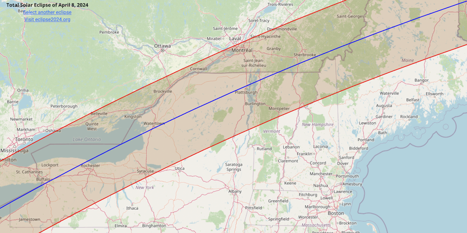
-
2
-
-
1 hour ago, Chrisrotary12 said:
1 run is an aberration, 2 is a coincidence, 3 is a trend. Forecasters shouldn’t flinch because 1 suite of models shifted 50-100 miles at day 4.
Agree.
But in fact this was several days across multiple models (alternately GFS and Euro, and their ensembles) variably showing a track inside of 100 miles from Cape.NHC did a good job with this. The mode of guidance tracks (which was on left edge of cone for several days) never changed their mean.
-
1
-
-
5 minutes ago, 40/70 Benchmark said:
This was always a trivial ordeal in my mind.
Yeah you were solid with this.
I think I opened with a 10% chance of SNE landfall last weekend iirc, but the trends of the past 2 days made me nervous (of home damage, not of being wrong!)
Surf will be spectacular regardless.
Hoping for sake of Maine and NS that this could tick even further east.
-
1
-


Monitoring first regional significant winter impact event. Magnitude likely tempered. At this time NE PA/SE NY and SNE primarily. Jan 7/8.
in New England
Posted
Maybe the biggest change on this 0z vs. 12z Euro run is lead wave seems to move faster... vortmax is ~100-150 miles further east by 0z Sunday.
And so the surface low is east. For example, 18z Sunday, ~50 miles east instead of over Nantucket.
I don't think we have enough to call this a definitive trend vs. impactful wobbles.