

wxsniss
-
Posts
5,788 -
Joined
-
Last visited
Content Type
Profiles
Blogs
Forums
American Weather
Media Demo
Store
Gallery
Posts posted by wxsniss
-
-
At least for inside 128, not feeling a surprise >3" snow:
DPs:
Still an 850 tongue on 0z NAM
6z:
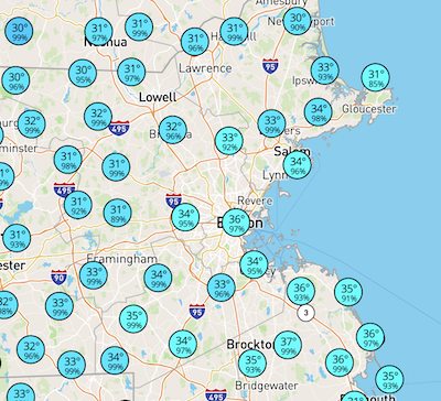
Station: KBOS
Latitude:   42.37
Longitude: -71.02
Elevation:  37.29
     Press    Height   Temp    Dewpt     Dir    Spd
SFC  1023.6       37      0.5     0.1      51     13
M    1000.0      224     -0.8    -1.1      57     26
S     950.0      633     -1.7    -2.0      86     32
S     900.0     1065     -0.2    -0.5      87     22
M     850.0     1523      0.3     0.0     112     13
S     800.0     2009     -0.1    -0.4     147      9
S     750.0     2526     -0.4    -0.7     201     16
M     700.0     3077     -1.9    -2.3     229     25
9z:
     Press    Height   Temp    Dewpt     Dir    Spd
M    1000.0      214     -0.7 -9999.0      53     24
S     950.0      624     -0.4    -0.7      91     28
S     900.0     1057     -0.1    -0.4      96     23
M     850.0     1515      0.2    -0.1     123     13
S     800.0     2001     -0.5    -0.7     158      9
S     750.0     2517     -0.7    -1.0     239     16
M     700.0     3067     -2.2    -2.5     261     25
-
 1
1
-
-
6z Friday on NAM:
Station: KBOS Latitude: 42.37 Longitude: -71.02 Elevation: 37.36 Press Height Temp Dewpt Dir Spd SFC 1024.1 37 0.1 -0.4 51 13 M 1000.0 227 -1.0 -1.4 57 27 S 950.0 636 -2.9 -3.4 83 33 S 900.0 1066 -1.2 -1.6 96 25 M 850.0 1523 -0.0 -0.3 119 20 S 800.0 2008 -0.7 -1.0 139 20 S 750.0 2524 -1.1 -1.4 181 16 M 700.0 3073 -2.6 -3.1 219 22 S 650.0 3658 -5.1 -5.9 234 28 S 600.0 4284 -8.2 -9.2 243 35 S 550.0 4955 -11.7 -13.1 248 45 M 500.0 5679 -16.0 -17.8 251 54 -
Did not expect these heavy rates (admittedly didn't really pay attention to guidance on this event)... roads are almost completely white with cars crawling near Fenway, briefly has the look of a moderate snowstorm
-
42 dBz over Boston, all snow
-
1
-
-
Massive flakes almost like the SWFE finale Jan 26... all snow near Fenway
-
2
-
-
Pounding great dendrites occasional quarters... roads starting to whiten near Fenway
-
1
-
-
< 1/2 mile now in Boston... wish this would last
CC has mix line to south shore? (further west looks down by CT/MA border)
-
20 minutes ago, The 4 Seasons said:
what site/software is that with that radar and all those overlays etc? Something private, in house stuff or is that from a paywalled site you think?
No idea either… you might want to DM the original tweet by @weathernut27
Would be amazing to archive a searchable library of storms in this way
(and something I’ve long wanted to do but never have time: archive how all the main models performed for each storm)
-
One of the better timelapses I've seen overlaying H5 + surface + radar, showing cyclogenesis and capture:
https://x.com/WeatherNut27/status/2026280880675913988?s=20
https://twitter.com/WeatherNut27/status/2026280880675913988?s=20
(and if anyone knows, let me know how I can get these to embed)
-
1
-
 1
1
-
-
Funny, classic New England:
https://x.com/FallRiverReport/status/2026010622186442928?s=20
-
1 hour ago, CoastalWx said:
Watching WCVB. Man from something that was a brush two days out and then what happened….Christ. Wow.
If this was at the benchmark, HFD, ORH and BOS would
have been smoked.
Yeah. Boston area was literally 40 miles from 40 inches. Benchmark track would've been a top 3 storm of all time for pike region. Like 2015-level complete-grid-shutdown no-school-for-week.
As is, still easily a SNE HECS considering impacts south shore to coast.
-
Drone video from Scituate at peak, really impressive... no wonder 100% without power:
https://twitter.com/accuweather/status/2026316284682760389?s=20
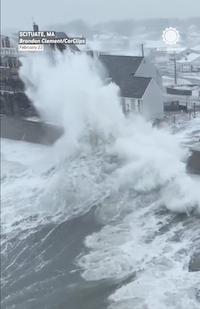
> 200k in EMA still without power on Eversource
-
2
-
-
1 hour ago, BRSno said:
Really thought BOS was gonna easily pass 24". But not too shabby at all.
Yeah I was sure we'd hit 18. We were close... got a little robbed with subsidence in the closing hours while adjacent south shore was a 1-2"/hr assembly line. Obviously not complaining... there were much bigger losers in this storm.
-
1 hour ago, Hoth said:
I don't know about you guys, but I always feel a little melancholy when a big storm is coming to an end. You just know it could be many years before you experience something like it again.
1 hour ago, HoarfrostHubb said:I definitely feel that way at times. The build up is amazing... sometimes almost as good as the actual event.
And then... withdrawal...
Every time.
Funny how random strangers can share the same intense emotions, and conversely feel estranged from people immediately around them who don't get it.
The chase, the exhilaration as the unlikely breaks our way, the thrill of the event, the sleep deprivation... then it's over and mundane reality returns. I jokingly warned my wife earlier tonight that I'm having post-storm dopamine withdrawal.
Part of what keeps us coming back every year.
-
4
-
-
16 minutes ago, weathafella said:
Some pretty heavy snow here from that one. Should add at least an inch or 2.
Some of the best snowgrowth too with that last band, maybe because winds have subsided
Let's see if remnant fronto can congeal to give us another moderate+ band
20z HRRR has snow falling until 8-9pm
Brookline schools closed Tuesday
-
Back to heavy rates in Boston with this band setting up
We continue this for several hours Logan will break 18"
-
1
-
-
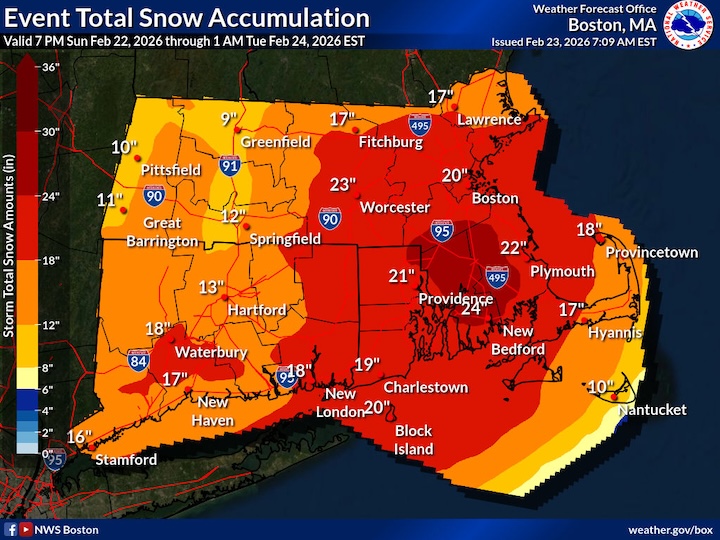
0100 PM     Snow             Logan AP                42.36N 71.01W
02/23/2026  M14.4 Inch       Suffolk            MA   Official NWS Obs
-
1
-
-
7 minutes ago, RI Rob said:
Does Boston cross the 12" mark?
Brookline just west of city was at least 10" at 9am... no way Logan hasn't already topped 12", and little doubt they reach 16"+ by end
-
230k+ power outages on Eversource Eastern MA
most of Cape Cod 90-100% out
Plymouth 72% out and rising
-
3 minutes ago, Boston Bulldog said:
Similar conditions here. Just on the fringe of an all-timer, but still a fantastic storm
Always appreciate your posts, nice to have some hyperlocal validation and analysis
Wonder how @weathafella's doing
I'm hoping we're in decent position for the pivot and can also benefit from farther west fronto
3k NAM keeps us in decent rates noon through 7pm, hopefully at least another 6-8"
-
3 minutes ago, CoastalWx said:
Band just keeps coming. This is surreal.
Wish it was just like 10 miles further west but we're still getting 1"/hr+ at minimum
What are your totals? I have no idea precisely what we have, shoveled earlier guesstimating 10-12" around 9am
-
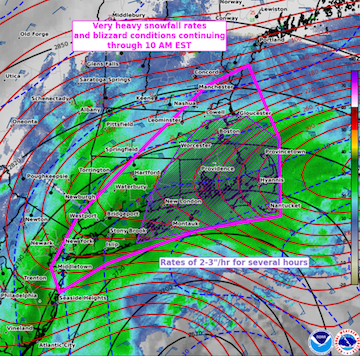
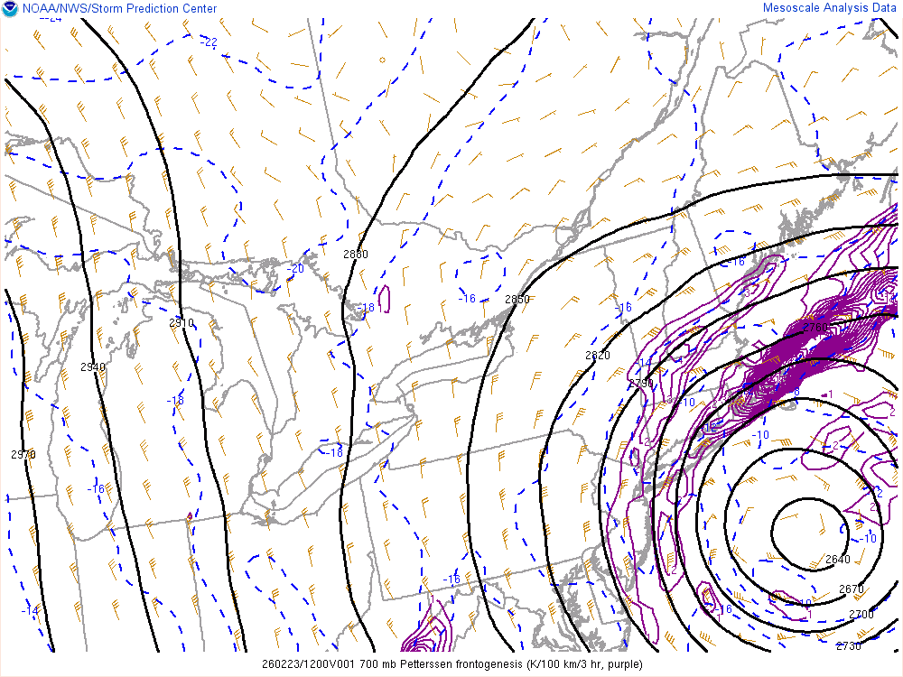
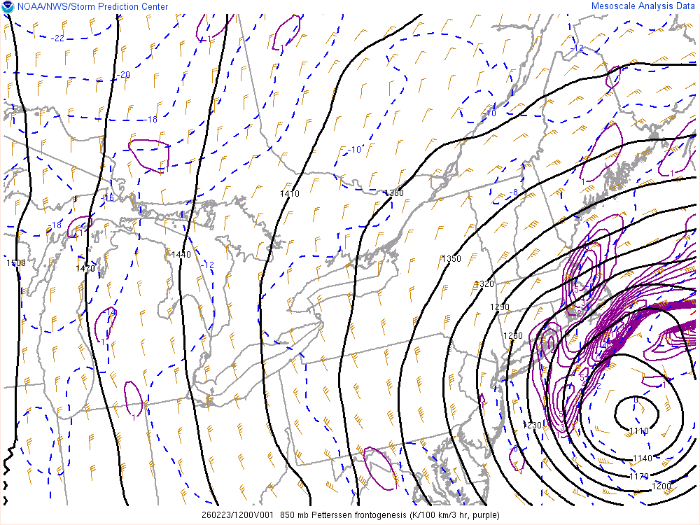
Meso Discussion from a few hours ago:
   Mesoscale Discussion 0117
   NWS Storm Prediction Center Norman OK
   0413 AM CST Mon Feb 23 2026

   Areas affected...parts of the Northeast and southern New England

   Concerning...Blizzard

   Valid 231013Z - 231515Z

   SUMMARY...Very heavy snowfall rates of 2-3 inches per hour and
   widespread blizzard conditions should persist across Long Island and
   southern New England through 10 AM EST.

   DISCUSSION...Classic bomb cyclone/nor'easter off the Northeast coast
   will slow its deepening over the next few hours as it tracks
   northeastward off the southern New England coast through midday. As
   this occurs, multiple bands of very heavy snow from NJ to southeast
   MA should consolidate into one primary band across Long Island to
   eastern MA through mid-morning. Extremely enlarged low-level
   hodographs are indicative of the impressive warm conveyor north of
   the cyclone. In addition, very high KDP values detected within and
   somewhat below the dendritic growth zone amid base reflectivity
   values around 35 dBZ all point to highly prolific snowfall rates of
   2-3 in/hr. From eastern Long Island through eastern MA, this appears
   likely to persist for several hours. Measured severe wind gusts
   should persist in this same region, supporting widespread blizzard
   conditions.

   The aforementioned slowing of cyclogenesis and northeastward track
   will eventually yield a more progressive tapering of very heavy
   snowfall rates from the southwest towards late morning.

   ..Grams.. 02/23/2026
-
1
-
 1
1
-
-
-
Incredible blizzard conditions
Located in Brookline just outside Boston
Windows caked, can barely see a few hundred yards, must be at least 2/hr, occasional wind roar
@weathafella hope you’re loving this and don’t lose power
> 100,000 in Eastern Mass lost power and rapidly rising
March Madness
in New England
Posted
KBOS 170554Z 19029G54KT
62mph