

wxsniss
-
Posts
5,444 -
Joined
-
Last visited
Content Type
Profiles
Blogs
Forums
American Weather
Media Demo
Store
Gallery
Posts posted by wxsniss
-
-
-5F at 10pm
This is really impressive
Went for a walk... can't really be outside barehanded for more than a minute
I poured water down a driveway apron out of curiosity... the streams froze at ~1 foot length before they reached the bottom of the apron
-
 1
1
-
-
That ORH ASOS is such a debacle on a potential record night.
As expected from 925mb, some of the most intense gusts and fastest plummet in past 2 hours. Should abate a bit after 10pm
4F 6:50
2F 7:27pm
1F 7:40pm
0F 7:55pm
-1F 8:20pm
-2F 8:33pm
MBY probably plateaus somewhere -10-12
In case wasn't posted earlier:
Record Low Temps Fri Feb 3...
Boston-5 in 1881
Hartford-9 in 1961
Providence-3 in 1955
Worcester-7 in 1971Record Low Temps Sat Feb 4...
Boston-2 in 1886
Hartford -8 in 1965
Providence -2 in 1918
Worcester -4 in 1934Record Low Maximum Temps Sat Feb 4...
Boston 11 in 1886
Hartford 12 in 1996
Providence 13 in 1996
Worcester 8 in 1908-
1
-
 1
1
-
-
1 hour ago, wxsniss said:
4F 6:50pm
Close to 3/hr
0 by 8:30pm?
2F 7:27pm
1F 7:40pm
0F 7:55pm
-
46 minutes ago, wxsniss said:
4F 6:50pm
Close to 3/hr
0 by 8:30pm?
2F 7:27pm
1F 7:40pm
-
37 minutes ago, wxsniss said:
4F 6:50pm
Close to 3/hr
0 by 8:30pm?
2F 7:27pm
-
4F 6:50pm
Close to 3/hr
0 by 8:30pm?
-
8F
At least we can say we've reached rates of 1-2 / hr for something this winter
-
 3
3
-
-
12F to 9F in past hour, we're plummeting
Delayed arrival definitely helping
Steepest 925 advection looks incoming over next 4 hours
-
14F to 12F in last 45 min
-
KMWN 1849Z 290 78G92KT –37/–37
..."Winds will continue to increase through the rest of the day, with winds speeds reaching 80-100 mph by Friday afternoon. Model guidance is also indicating that the tropopause could dip below the summit Friday night. As a result, winds will become more compressed in the lowest levels of the atmosphere, leading wind speeds to increase even further overnight Friday. The highest wind speeds will occur sometime between Friday night into Saturday morning as wind speeds ramp up to 100-115 mph with gusts up to 135 mph. Higher gusts are not completely out of the question, with the possibility for winds to peak as high as 140 mph very early Saturday morning.
Wind chills will be incredibly low and very dangerous, particularly above treeline. Wind chill values will start around 60 below to 70 below Friday morning and will continue to fall even further over the rest of the day. The coldest air from the center of the polar vortex will move through the region Friday night which will also coincide with the period of strongest winds. As a result, wind chill values will drop to a range of 100 to 110 degrees below zero Friday night.I want to emphasize the danger of this cold. In these brutally cold conditions, the risk of hypothermia and frostbite will be exponential. These frigid cold conditions will quickly rob you of body heat, with the possibility that frostbite could develop on exposed skin in under a minute. Even small mistakes can prove deadly, with a simple slip or fogged goggles leading to a potentially life-threatening situation. In this type of weather, rescue services will have a difficult time responding to any emergency effectively."
https://www.mountwashington.org/experience-the-weather/mount-washington-weather.aspx
-
1
-
-
4 hours ago, Ginx snewx said:
Name that storm.

~12am-4am 1/27/2015?
Consolidated into a more meridional megaband later that morning
-
Opening bid from Box…
looks like a 70:30 GFS:NAM blend
Almost a redux of today’s totals, with more of a latitude component and no CCB jack east

-
2
-
-
KBOS still holds futility record over 1936-37
As we anticipated, North Shore cleaned up with that band
PNS excerpts:
...Suffolk County...
Logan AP                     2.1 in    0717 PM 01/23   ASOS
...Essex County...
2 ESE Peabody                6.5 in    0645 PM 01/23   Amateur Radio
Gloucester                   6.0 in    0654 PM 01/23   Trained Spotter
1 SE Lynn                    6.0 in    0600 PM 01/23   Amateur Radio
Newburyport                  5.0 in    0535 PM 01/23   Trained Spotter
...Middlesex County...
Ashby                        6.3 in    0545 PM 01/23   Amateur Radio
1 WNW Pepperell              5.6 in    0505 PM 01/23   Trained Spotter
Lexington                    5.2 in    0545 PM 01/23   Public
1 ESE Framingham             5.0 in    0610 PM 01/23   Public
1 SW Lexington               4.7 in    0601 PM 01/23   Trained Spotter
...Plymouth County...
1 SE Cohasset                2.5 in    0640 PM 01/23   Public
...Worcester County...
4 NW Ashburnham              7.5 in    0638 PM 01/23   Amateur Radio
Ashburnham                   6.3 in    0621 PM 01/23   CO-OP Observer
2 ENE Fitchburg              6.1 in    0618 PM 01/23   Public
1 NE Lunenburg               6.0 in    0614 PM 01/23   Public
...Providence County...
2 ENE Burrillville           3.0 in    0542 PM 01/23   Trained Spotter
1 S Smithfield               2.5 in    0624 PM 01/23   Public
...Tolland County...
1 SSW Coventry               1.9 in    0635 PM 01/23   Public
5 E Rockville                1.8 in    0400 PM 01/23   Amateur Radio
2 NNW Bolton                 1.5 in    0400 PM 01/23   Amateur Radio
-
3
-
-
Awaiting PNS, wonder if KBOS passed 1936-37 (all time ratter) total today… still ahead of 2011-12 in futility
-
5 minutes ago, ORH_wxman said:
Funny I posted that and literally liken5 min later we are pounding perfect dendrites again. Awesome snow growth…must be a deeper area of lift punching the DGZ in this band here.
Nice! Hoping that propagates downstream, visibilities currently > 1 mile closer to Boston
The crappy BL temps are more apparent when snowgrowth and rates are poor
Metro area might pull off another 0.5-1" as this last band rotates in
-
By far, the best report I just received related to this snowstorm: "he refuses to fall asleep for his nap, he is too excited about the snow" (referring to my 2.5-year-old son)
-
5
-
-
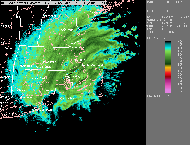
10 minutes ago, ORH_wxman said:
Snow growth isn't pristine like it was in that first monster band, but vis is down again and it "Feels" like a snowstorm in this stuff.
Agree
I posted about that earlier... looks like best lift is now below DGZ vs. better crosshair earlier
And correlated with KBOS ticking up to 33.8 (an effect, not a cause)... and streets clearing up quickly
-
I think North Shore has a shot at >4"
Snowgrowth in Boston metro (now in between the best bands) not as good now and visibilities have increased... KBOS ticked up to 33.8/32
Anticipating at least another 0.5-1", band over ORH will rotate through
-
1
-
-
0.25 mile vis KBOS!!!
Mesos ftw, the heavy rates overcame the crappy BL
Roads are whitening
Positive bust of yore to buck the season tenor
-
Best snowfall of season for Boston metro, 0.5-0.75 mile visibility
Hours of this ahead
-
~0.75 mile visibility in Boston
and in a first for the season for the city: roads are actually starting to whiten
-
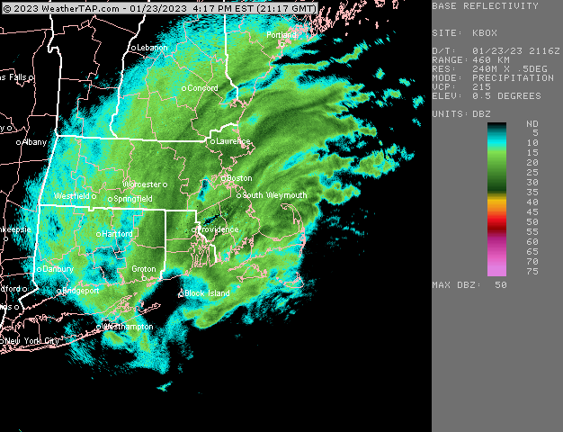
32 / 30 KBOS, just in time for best rates entering for next few hours!
-
Mesos ftw
2-4pm window consistently advertised for metrowest / Boston area
-
30-35 dBZ entering 495 belt strong finish in the making

The event of the season - 2 days of hell!
in New England
Posted
Pour out some water onto an incline or pole... pretty cool, it's a rare night