

wxsniss
-
Posts
5,788 -
Joined
-
Last visited
Content Type
Profiles
Blogs
Forums
American Weather
Media Demo
Store
Gallery
Posts posted by wxsniss
-
-
16 minutes ago, Patfan1987 said:
Anyone want to track wild fires in CA until it snows again?
I posted in Banter, but I guess this thread is basically that until the Miracle of 0z... check out this reverse LES:

-
 2
2
-
-
11 minutes ago, WxWatcher007 said:
The precision it takes to smoke Dallas, Atlanta, the upper south, central Plains, Ohio Valley (Cincinnati), western NY, DC, most of Virginia, the Mid-Atlantic coast, and northern NJ (in December) while simultaneously porking virtually all of non elevated New England is truly extraordinary.
Well said. On Sunday I was bullish and tossed the Euro because it was "threading the needle to a non-event here"... I underestimated.
Pretty sure this is correct looking at climod2: for KBOS and probably multiple SNE sites, 2022-2025 so far the worst 3 year snowfall in recorded history. And nothing comes close.
-
Almost looks like LES in reverse…

-
55 minutes ago, ORH_wxman said:
All different flavors of meh/non-events on these runs. It's still close to something bigger, but we need a bump now....00z needs something notable to keep this threat alive. We're almost administering CPR here....not quite yet, but soon.
14 minutes ago, 40/70 Benchmark said:Yea, that is my take...this is a great illustration of why I was in on this over the weekend and yesterday...wasn't worried about the N stream, but didn't expect the s stream to reverse to shit 4 days out.
Haunts me that I wrote "Euro is threading the needle to a non-event" on Sunday... the way these streams were positioned and take-your-pick of vorticity boluses, this looked so promising over the weekend... now it's variations of a theme of fail
Non-zero chance we get improvements with better sampling of northern energy, but yeah that S stream backing out makes this such a gut-wrenching miss... what a stretch for SNE
-
0z EPS not improved vs. 12z... initially looked better at H5 through 96hrs but ultimately surface low members largely OTS... there's a handful of 960s-970s members in there so seems phase does eventually happen but too late for impact
A negative sweep at 0z is definitely concerning and bucks the model momentum today.
Northern stream energy is the critical variable, so there's still room to trend back to a better phase with improved sampling, but that's gotta happen in the next ~24-36 hours (looks like energy enters BC coast ~12z Wednesday)
-
 1
1
-
-
Definite step back
Weaker northern stream energy + less proficient phase --> more progressive trough --> scraper and less intense surface low.
But not sure I'd call this a cave to Euro... Euro multiple cycles has a low far OTS and barely latitude of Delaware... GFS / many GEFS members have had multiple runs deeper low vicinity of BM
-
1
-
-
19 hours ago, wxsniss said:
I’m relatively bullish on this.
Feels like there’s multiple ways to have some impact… longwave pattern is decent, stronger northern energy and/or the slightest stream interaction gets at least some impact to 95 corridor/SNE…Usual caveats, nothing is guaranteed at this point and details tbd… but the “thread the needle” outcome is OTS imo.
Continued big improvement with 18z GEFS at H5 and surface members
Model momentum today favors a huge impact, details tbd... I maintain what I said yesterday:
Euro/EPS is the one threading the needle to a non-event. Won't be surprised if it abruptly jumps in one cycle to a big hit between tonight - Tuesday 12z.
-
2
-
-
I’m relatively bullish on this.
Feels like there’s multiple ways to have some impact… longwave pattern is decent, stronger northern energy and/or the slightest stream interaction gets at least some impact to 95 corridor/SNE…Usual caveats, nothing is guaranteed at this point and details tbd… but the “thread the needle” outcome is OTS imo.
-
1
-
-
Today's cold snowless winter day ≈ Pats win #4... useless and unwanted by winter/Pats fans.
Just looked GFS 18z/6z vs. 12z H5 so hugely different... especially northern stream energy dives down better on 18z/6z instead of getting lost over Manitoba. Unfortunately I don't think we'll be confident with that variable until closer, but I'm not so discouraged by the 12z suite. When the outcome is so sensitive to just the slightest stream interaction, I actually lean against OTS with zero impacts as depicted at 12z.
-
2
-
-
3 hours ago, weathafella said:
We actually went to the movies to see the new Dylan flick-A Complete Unknown. It was very well done! That was followed by some pretty bad Chinese food.
All somehow related ways to mark the holiday
")
Merry Christmas and Happy Hanukah all!
Here’s to some region-wide crushings of yore in January…
-
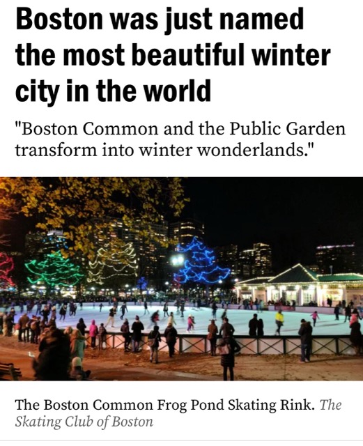
2 hours ago, ORH_wxman said:
The common really is awesome when there’s snow during Christmas season. Next few nights are gonna be really awesome for skating on Frog Pond with all the lights and snow.
1 hour ago, mreaves said:It has nothing on Quebec City though.
4 hours ago, moneypitmike said:That's a sad statement about the world.
Cobblestoned lamp-lit Beacon hill is pretty iconic too
Anyway, not necessarily agreeing with this list (methodology was by showing people photos), but here were top cities:

-
1
-
-
And while we have a fresh example, put me in the column of folks who are a little delighted (relieved?) to see that Euro-AI was completely useless this last event.
Wonder how the Google GenCast that received all this media hype a few weeks ago did…
-
1
-
-
6 hours ago, CoastalWx said:
Comm ave in the city with all the lights and snow looked like something from a post card. I got engaged 16 years ago under deep snow in the common. Nothing beats wintry Boston.
-
2
-
 2
2
-
-
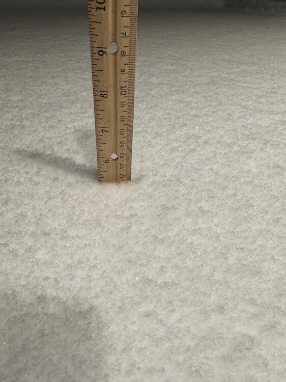
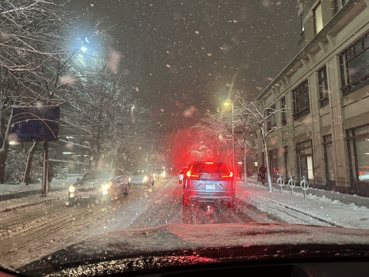
Took a weenie drive... almost a foreign feeling, it looks like WINTER... finally!
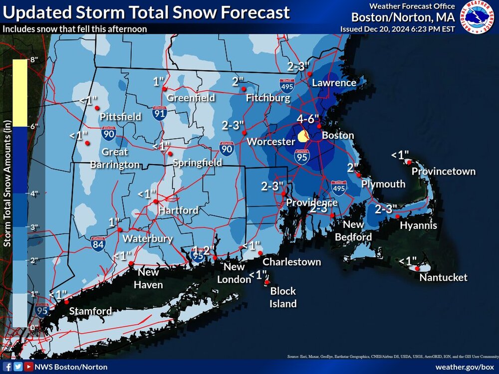
~5-5.2" measurements near Coolidge Corner
Amazing how a positive bust (and for a change one where we're not futilely waiting to wetbulb) can partly heal the famished, even if it was just a few inches.
-
3
-
-
14 minutes ago, CoastalWx said:
Just have to laugh. What a beat down these last 3 years.
Completely sympathize.
I was fully expecting mostly white rain in the city with C-1" to finish, par for the past 3 years.
Literally 5 mile of CF placement made all the difference for you guys further east.
Still have a few hours and CF looks over/past you, hopefully you pick up a few:
-
13 minutes ago, 78Blizzard said:
That band is literally stuck right over my hood. Visibility lowest its been here.
Westwood jack?
-
I'm trying to figure out... was this truly a NAM coup, or was it right for the wrong reasons i.e., OES + slightly further east CF (the larger synoptic snowfall from CCB in fact remained well offshore) that achieved the higher amounts in Boston / southwestern burbs...
-
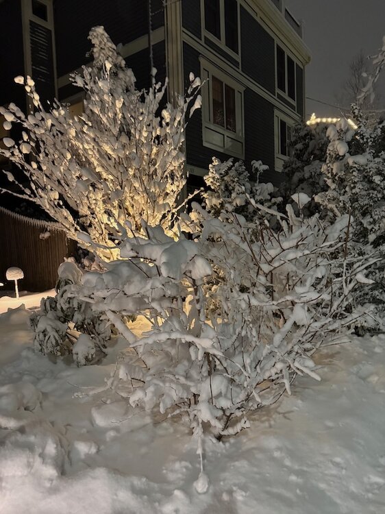
Best snowfall in Boston metro in years... years since we've had snow covered roads like this in the city:
-
7
-
 1
1
-
-
1 minute ago, CoastalWx said:
This could be a heck of a bust for BOS down to interior SE MA. And I mean in a good way. Compared to the forecasts I saw.
Yep, and fwiw much of that bust so far is OES and placement of the CF
Bodes well for later this afternoon when larger synoptic stuff develops
18z HRRR looks great for 4-6pm
-
1
-
-
Honestly was surprised to be on NW side of CF all morning here in Fenway, I thought it would set up closer to 128 and we'd be in white rain all day
Boston metro has not had a positive bust for years, meager as this is it's a great feeling. We've been < 1 mi vis for hours. Guesstimating 1-2" so far and all OES.
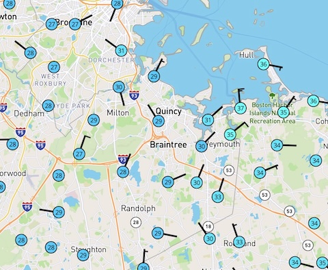
I think this is the CF now, between Quincy / Weymouth and Canton / Randolph, slinking SE... @CoastalWx and others you should hopefully turn soon

-
1
-
-
And last night I thought NAM should be introduced to DOGE…
This OES already beating my expectations this morning. CF sitting just southeast of city, great snow growth in Brookline.
-
 1
1
-
-
Destructive interference from that lead vorticity and we just miss a significant event... if this were a single isolated model run, I'd be tempted to attribute the disconnect between H5 and surface low position as runaway convection
48-60 hrs out, still not unrealistic for this to weigh the lead annoying energy slightly less as we get closer
-
4 minutes ago, weathafella said:
Well if you just look at Boston and metro west, 1993-94 was a major all timer. Certainly in my top 3 experienced as is 2014-15 and probably 1960-61. 1995-96 goes to #4 due to the spectacular melts-lasting for weeks.
93-94 was my first winter in Boston. Man were my expectations irreversibly distorted.
The potential and actual results of this December remind me of a Jerod Mayo pre-season quote I heard on WEEI this morning: "1000% percent... we have a lot of cap space... ready to burn some cash"
-
Euro definite improvement vs. 12z... trough looked more promising than surface reflection, but continued trend of slightly more negative tilt and vort more consolidated
Verbatim still just a very minor event for Cape / SEMA


Tracking either the biggest storm to affect at a regional scale since perhaps 2013 ... or, a complete whiff. Pick-em'
in New England
Posted
The assumption is always better sampling -> better result lol