

wxsniss
-
Posts
5,799 -
Joined
-
Last visited
About wxsniss

Recent Profile Visitors
6,862 profile views


.thumb.jpg.aec747d13df1d95d5fed34574f74d4fd.jpg)


-
Now warned!
-
-
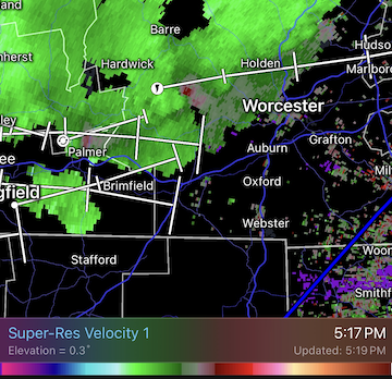
Decent velocity curl west of Worcester 5:15pm...
-
Very loud deep boom, 2:11pm heard in Natick MA Apparently heard across eastern MA and RI
-
Impressive little system, let’s get a critter like this in January MWN earlier this week and now:
-
As usual, model extremes were wrong... not a shutout like AI-GFS had for days, not a 3-day washout like EC / ens had a few days ago... converging towards a 1.5 of 3 days dry: completely dry Saturday (probably copy of today cloudy highs to 60s) worst day Sunday Monday looks dry 2nd half... Only reason I'm scrutinizing is a family event on Charles Saturday evening so thankful it looks dry
-
High stakes weekend... EPS/GEFS and EC are wettest models, but if anything maybe ticking drier AI-GFS/EC and GFS driest... 12z AI-GFS still a shutout until late Monday, but ticking less suppressed
-
Hope so. AI-GFS complete shutout vs. Euro is wet most of Sat night-Monday Box had been riding NBM, 50%+ chance showers all weekend...
-
Surprised by that number. Was about 3 min torrential and occasional pulses of horizontal windswept white curtains of rain, cars slowed down with hazards on, minor transient street flooding… decent but nothing photo-worthy. Didn’t see any tree damage.
-
Let's see if we warn inside 128 Hearing some rumbles near Fenway
-
Have an event on the Charles River near Boston Saturday evening... AI-GFS/ECs for a few days now have led the way keeping the ~1035 high in place east of us and suppressing precipitation southwest of SNE... hope it's correct!
-
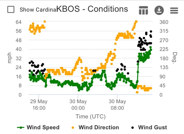
KBOS 170554Z 19029G54KT 62mph
-
At least for inside 128, not feeling a surprise >3" snow: DPs: Still an 850 tongue on 0z NAM 6z: Station: KBOS Latitude: 42.37 Longitude: -71.02 Elevation: 37.29 Press Height Temp Dewpt Dir Spd SFC 1023.6 37 0.5 0.1 51 13 M 1000.0 224 -0.8 -1.1 57 26 S 950.0 633 -1.7 -2.0 86 32 S 900.0 1065 -0.2 -0.5 87 22 M 850.0 1523 0.3 0.0 112 13 S 800.0 2009 -0.1 -0.4 147 9 S 750.0 2526 -0.4 -0.7 201 16 M 700.0 3077 -1.9 -2.3 229 25 9z: Press Height Temp Dewpt Dir Spd M 1000.0 214 -0.7 -9999.0 53 24 S 950.0 624 -0.4 -0.7 91 28 S 900.0 1057 -0.1 -0.4 96 23 M 850.0 1515 0.2 -0.1 123 13 S 800.0 2001 -0.5 -0.7 158 9 S 750.0 2517 -0.7 -1.0 239 16 M 700.0 3067 -2.2 -2.5 261 25
-
6z Friday on NAM: Station: KBOS Latitude: 42.37 Longitude: -71.02 Elevation: 37.36 Press Height Temp Dewpt Dir Spd SFC 1024.1 37 0.1 -0.4 51 13 M 1000.0 227 -1.0 -1.4 57 27 S 950.0 636 -2.9 -3.4 83 33 S 900.0 1066 -1.2 -1.6 96 25 M 850.0 1523 -0.0 -0.3 119 20 S 800.0 2008 -0.7 -1.0 139 20 S 750.0 2524 -1.1 -1.4 181 16 M 700.0 3073 -2.6 -3.1 219 22 S 650.0 3658 -5.1 -5.9 234 28 S 600.0 4284 -8.2 -9.2 243 35 S 550.0 4955 -11.7 -13.1 248 45 M 500.0 5679 -16.0 -17.8 251 54
-
Did not expect these heavy rates (admittedly didn't really pay attention to guidance on this event)... roads are almost completely white with cars crawling near Fenway, briefly has the look of a moderate snowstorm
