-
Posts
2,388 -
Joined
-
Last visited
Content Type
Profiles
Blogs
Forums
American Weather
Media Demo
Store
Gallery
Everything posted by burrel2
-

Winter Storm Izzy Obs Thread
burrel2 replied to Prismshine Productions's topic in Southeastern States
3 inches here. Ripping powder. 31.2 degree's. What a time to be alive! Got right at 1.5 inches from 4am to 5am. -

Winter Storm Izzy Obs Thread
burrel2 replied to Prismshine Productions's topic in Southeastern States
at the moment i'm getting clean dendrites and the aggregates aren't too big. I think we're a decent amount below 0C thorugh the column here for the time being anyway. 1.5 inches 31.2 -

Winter Storm Izzy Obs Thread
burrel2 replied to Prismshine Productions's topic in Southeastern States
I got 1 1/4 inches measured 2 miles north of Clemson. Moderate snow falling and 31.9 degrees. Radar lighting up to the south. -

Winter Storm Izzy Obs Thread
burrel2 replied to Prismshine Productions's topic in Southeastern States
already have an inch on the car top... driveway covered. absolutely ripping parachutes! -

Winter Storm Izzy Obs Thread
burrel2 replied to Prismshine Productions's topic in Southeastern States
oh mama!!!!! SN+ This band is the real deal guys! -

Winter Storm Izzy Obs Thread
burrel2 replied to Prismshine Productions's topic in Southeastern States
Light snow with a heavy death band knocking on my door now. Sleet line appears to have stalled just south of I -85. This is where we need to pick up a few inches in the next hour or so. -

Winter Storm Izzy Obs Thread
burrel2 replied to Prismshine Productions's topic in Southeastern States
It's ok. This will be an inch plus of liquid and it'll all be frozen. Great winter storm! We will get our high ratio powder next week! lol -

Winter Storm Izzy Obs Thread
burrel2 replied to Prismshine Productions's topic in Southeastern States
a little sleet mixing here and it's evident on CC radar. Ugh... looks like the line is crashing back south though. Models show this line pushing back south of 85 and hanging out there for 2-3 hours before moving north again. Fingers crossed! Edit: Back to all snow and ripping! Crisis averted.. for now. -

Winter Storm Izzy Obs Thread
burrel2 replied to Prismshine Productions's topic in Southeastern States
ground turning white, ripping quarter sized flakes, temp down to 32.9. I expect to have nws_gsp's total snowfall forecast of 1 inch here in the next 45 minutes... then what? lmao I got a nice 2 hours of sleep... little late with the 1:30am alarm clock. missed the start of the action! -

Winter Storm Izzy Obs Thread
burrel2 replied to Prismshine Productions's topic in Southeastern States
Snow is flying here. Temp has crashed from 39 to 33 in the last 30 minutes. Let's go! -
Yea, i'm not expecting anything more than a very light glaze from freezing drizzle in between heavier sleet showers mid-day tomorrow. 95% of our precip will be snow or sleet.
-
Anybody else think this could be like, super bad in terms of power loss? Could go down in history as one of the worst ice storms, imo. We got a wide area with mid-upper 20 temps and freezing rain with sustained 15-25 mph winds gusting to 45-50mph. It's going to be bad, imo.
-
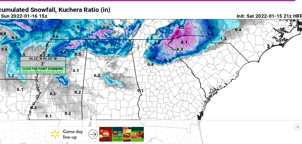
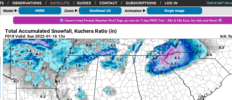
Just when I think the Hrrr can't get any better; it spits out this non sense. Upstate, SC... let's go!!! I'm honestly going to be very... very surprised if Oconee/Pickens/Greenville doesn't get at least 3-4 inches at this point. The writing is on the wall, front end thump incoming!
-
-
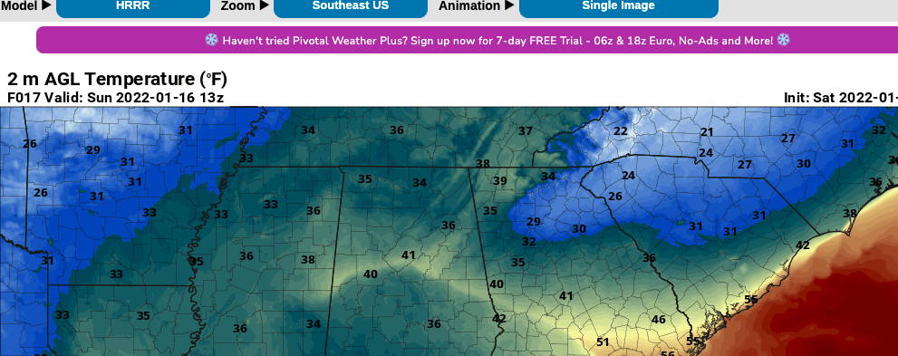
This run trended much colder and more advanced with the wedge. All the way in to ATL proper now. This is 8am and temps are still dropping across the upstate and GA.
-
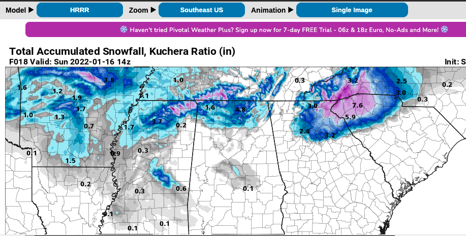
This is kuchera totals folks! With surface temps in the mid 20's at 8am! Lot's more sleet/snow to come! Whew!
-
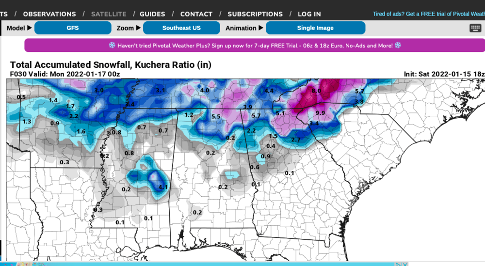
Hrrr is straight porn for the Upstate and NE Georgia. Complete jackpot paste job... It's becoming clear that this area is going to get hammered for at least a few hours tonight before any changeover to sleet happens. I think 2-4 is a conservative call at this point, (I -85 north in SC and Gainesville, GA and points North and East in Georgia).
-

2021-2022 Fall/Winter Mountains Thread
burrel2 replied to BlueRidgeFolklore's topic in Southeastern States
I mean if the Upstate gets 100% sleet it will add up to 2 or more inches.... and GSP says that graphic includes sleet accumulations. I just don't get these guys. -

2021-2022 Fall/Winter Mountains Thread
burrel2 replied to BlueRidgeFolklore's topic in Southeastern States
Clown show at nws_GSP. They've had Clemson go from 4-6 to 2-4 to Trace to 2-3 and now 1-2. The whole time models have supported 2-4 inches and honestly they have not wavered at all, and if anything I would say they support more like 3-5 forecast at this point. I'm starting to think there are some guys working there that like to forecast snow, and other guys who come in for a new shift that love to slash totals... wash, rinse, repeat. lol -
Here are my post-storm notes from a few recent events. feb 6, 2021 Miller a with -3 850s but warm boundary layer, started off as rain and 39 wetbulb, heavy rates flipped it to snow. Hrrr nailed transition and precip maxima, nam was way too warm at surface and too quick with warm nose and too dry. feb 20, 2020 started as rain around 10:00am, mixed with snow on and off all day until it ended around 6pm. Temp started at 44 and just didn't drop fast. HRRR nailed warm nose and low level temps. short range models were a little too wet, showed .5-.8 and i got .4
-
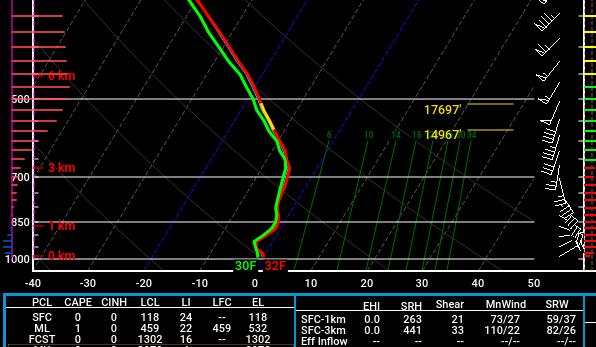
Also, NAM made a huge correction on warm nose for the upstate... Now looks similar to Hrrr, rgem, RAP, etc. Surface is still a little warm on NAM than other hi-res modeling, but it initialized 2 degrees too warm on temp and dewpoint here.
-
-
I'm over here debating on if snow/sleet cover from tomorrow's storm will last on the ground until the next storm. life is good!
-
You guys better sit down before you look at the 12z Euro. Cha Ching!
-


