burrel2
-
Posts
2,388 -
Joined
-
Last visited
About burrel2

-
https://tidesandcurrents.noaa.gov/stationhome.html?id=8725520 6.82ft and rising. that previous posted link of this station lags behind this one for some reason.
-
I mean it has upside... look at the 00z GFS for the upside max potential... that'd be historic for some folks. No reason to get too excited until the Euro jumps on board though. We saw this movie play out last week. (GFS showing snow and then complete cheap hooker fold). I'm a little more optimistic here though b/c the ukmet looks similar for now. And CMC has the trough axis pretty far west as well.
-
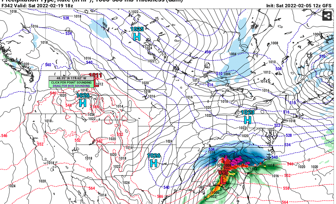
hard to tell much of anything on those crummy panels. Also, no way i'm believing the qpf output on the gfs if it's right with the 500mb height map. There would be way more liquid.
-
looks like a fairly potent trough on the 00z ukmet as well. Not GFS cutoff bomb material, but it's sharp.
-
Looks like a stronger/more cutoff version of the 12z ukmet really. 5h track very similar
-
mama cita!!!... check please!!!
-
I’m not going to complain bc I’ve got a decent hit from all the big ones in the that timeframe… but it’s almost always 2-3 inches of slop(except 5.5 inches with this last storm). But on the other hand 15-20 miles to my south has missed out almost entirely on all those storms.
-
Yea, especially up your way. At least your area has really cashed in on all the big ones for the last 5-6 years .
-
I think we’ve been spoiled with good December’s the last 5-6 years(not counting this year). Iirc, everyone averages more snow in March compared to December, historically.
-
So December was an F. You aren’t rating February on the 7th day of the month right?
-
Where's this pattern break down again that some ppl keep calling for?

-
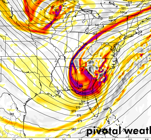
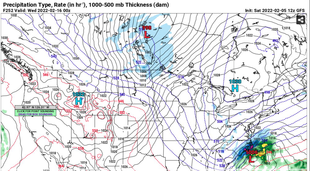
CMC also snowing over central NC at 240 hrs... the run was full of opportunities in the long range.
-
Not a bad look for mid-February... pattern breakdown cancel?
-
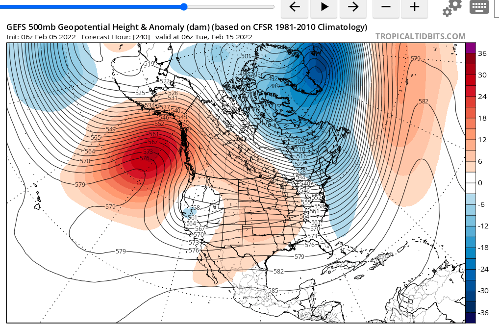
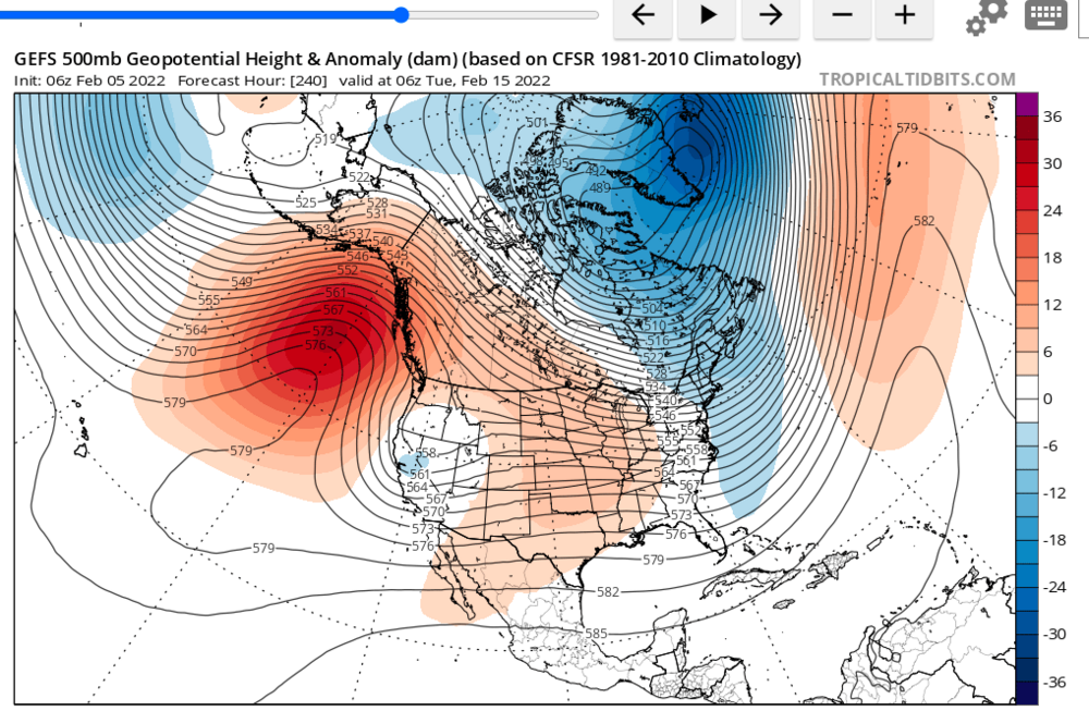
Why are you looking at average high temperatures to determine when the best chances for snow climatologically speaking? I'd think looking at historic snowfalls over the past 100 years. is more prudent. You know we have that data too, right? and Mid-Late February is "climatologically" the best time for our area to score a significant snowfall. Does that mean we will get a snowfall this year in our climo best time??? who knows, probably not b/c it's rare in general to get a significant snowfall any time during the winter for our area. But there's no reason to call winter over at the first of February b/c "climatology". Also how are you declaring the pattern starting in mid-february will not be ideal? 1. that's 10 days away and we don't really know how it will shake out. 2. The signals are mixed right now how the pattern will look in 10 days. It certainly doesn't look like a complete torch with a west coast trough and SER... Here's the latest GEFS mean for February 15th... not horrible.
-
Pattern looks ok long range to me with persistent ridging out west… the lack of threats on the models/ensembles in the long range is a little concerning though. Would like to see some storms materialize here soon in the day 8-12 timeframe before the pattern breaks.